Advisory Archive
Since yesterday morning the mountains got 8-11” of new snow near West Yellowstone and Cooke City with 5” near Big Sky and 2” in the Bridger Range and Hyalite. Wind has been south-southeast at 5-15 mph with gusts of 10-30 mph. This morning temperatures are teens to mid-20s F. today temperatures will reach high 20s F with southeast-southwest wind at 15-30 mph. Snow showers will continue, and by this evening expect 3-6” near West Yellowstone and Cooke City with 2-3” near Bozeman and Big Sky.


Overnight, a trace to an inch of new snow fell. Strong winds are out of the southwest to east up with gusts of 30-50 mph. Temperatures are in the teens and low 20s F. Strong winds will continue today out of the south and southeast. Snowfall will start this morning and intensify this afternoon, with 1-3” likely by nightfall. By tomorrow morning, expect 6-12” in the south and 3-6” in the northern mountains. Snow will continue through the day tomorrow.

Yesterday morning, the Bridger Range picked up 1” of new snow, with only a trace across the rest of the advisory area. Overnight, moderate winds shifted from west to east in the Bridger Range. Elsewhere, winds are 10-20 mph out of the south and southwest this morning, but will shift to the southeast today. Temperatures this morning are in the single digits and low teens F. High temperatures will be in the 20s F. Clouds will build this morning with snow showers possible, but no significant accumulations. Heavier snowfall is on the way tomorrow and tomorrow night.
Last night the northern Gallatin Range picked up 7” of new snow with 1” falling around Big Sky, Carrot Basin and Cooke City. West Yellowstone and the Bridger Range were missed. West wind gusted into the 50s yesterday and lessened a bit overnight. Throughout the day, wind will blow from the west to northwest at 10-20 mph with gusts of 30-45 mph. Temperatures dropped abruptly into the teens last night and are only expected to climb into the mid-30s F today. Skies will clear this morning and no new snow is expected until Friday night.
Wet Avalanches
Today’s weather forecast of wind and relatively cool temperatures will keep the wet snow avalanche danger LOW. However, if the temperatures warm towards 40F and the wind lessens and the sun is out, the wet snow avalanche danger could rise to MODERATE. The good news is that it will be obvious: on sunny slopes the surface snow will quickly wet and you will see pinwheels rolling downhill that could trigger loose, wet avalanches.

There is no new snow to report this morning, only wind. A moist westerly flow will keep skies partly to mostly cloudy as west to southwest wind blows steady at 15-30 mph with frequent gusts of 40-50 mph. Temperatures are currently in the mid-20s F and will rise into the 40s today. Tonight temperatures will drop back into the 20s, wind will continue and snow will fall. By morning I expect 1-2” of new snow with Cooke City getting 3-4”. Tomorrow looks to be sunny followed by a wintry weekend of snow, cold temps and wind.
In the last 24 hours, the Northern Madison and the Northern Gallatin Ranges and mountains around Cooke City received 8-10” of new snow and the other ranges received 2-4”. Winds were 10-20 mph from the west and mountain temperatures are in teens to low 20s F. Today skies will become clear with west winds 10-20 mph and temperatures warming into the low 30s F.
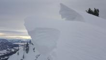
WET SNOW AVALANCHES
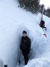
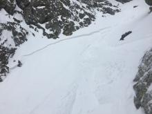
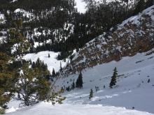
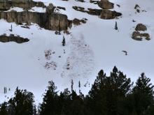
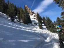
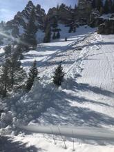
Since Saturday night the mountains have received 8-14" of new snow. This new snow will rapidly destabilize as it warms up today and natural wet avalanches sliding on this weekend's melt-freeze crust are possible. When it becomes easy to form a snowball with the new snow and you start seeing small pinwheels rolling down slopes, move to shadier aspects because the change from stable to unstable can happen rapidly. Watch Ian's video from Mount Ellis to learn more. Today, the wet snow avalanche danger will increase to CONSIDERABLE and human triggered avalanches are likely.


In the last 24 hours the mountains around Cooke City and West Yellowstone received an inch of snow yesterday morning, the Bridger Range picked up 2” last night and the rest of the advisory area remained dry. Winds were 5-15 mph from the southwest to the west. This morning, temperatures are in the teens to low 20s F. Temperatures today will rise into the upper 20s to low 30s F with winds from the west to southwest at 5-15 mph. By tomorrow morning the mountains around Big Sky and Cooke City will have 3-5” of new snow with other areas receiving 1-3”.

Last night temperatures dropped below freezing, wind died down and snow began falling. At 6 a.m. there is 7” of new snow in the Bridger Range, 2” in Cooke City and 4-5” everywhere else. Wind is from the west at 10-25 mph and mountain temperatures are in the 20s F. This morning another inch will fall and then skies will become partly sunny as mountain temperatures rise to near 40F.
There is no new snow this morning. Today starts out warm, dry, and mostly sunny. Winds are 10-30 mph out of the south and west with gusts of 30-50 mph. Temperatures are hovering around freezing. High temperatures today will be in the high 30s to 40s F. Winds will be 15-30 mph out of the SW. This afternoon a cold front will bring clouds and the chance of a brief drizzle before switching over to snow. Expect 1-3” of snow overnight.
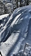
WET AVALANCHES
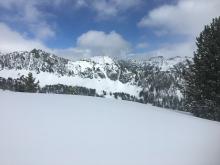
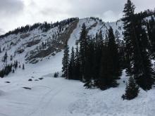
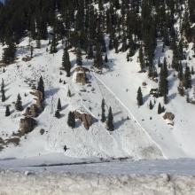
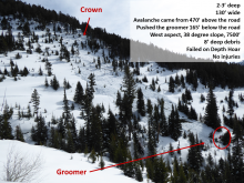
With another very warm day in store, wet avalanches are the primary concern. Yesterday, numerous small wet slides were seen from the Bridgers to West Yellowstone (details). With only a light freeze overnight, surface crusts will break down quickly this morning on sunny slopes. Be alert as the snow surface becomes wet. If you’re sinking deeper than your ankles into wet snow, avoid steep slopes (video). Slides may break only in top few inches or gauge deeper, especially where the snowpack is thin and weak. Plan to be off steep, sunny slopes by the early afternoon, especially if the sun doesn’t become obscured by clouds. Across our entire advisory area, the wet snow avalanche danger will rise to MODERATE as surface crusts break down.


Sunny skies and warm temperatures continue today. There is no new snow this morning. Winds are 10-30 mph out of the south and west with gusts of 30-50 mph. Southwest winds with strong gusts will continue today. Temperatures this morning are in the high 20s to 30s F and will rise into 30s and 40s this afternoon. Tomorrow will start out warm with cooler air and precipitation moving in by tomorrow night.
WET AVALANCHES
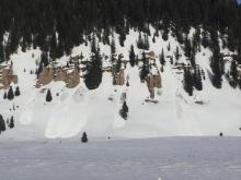
The strong March sun and warm temperatures will increase the wet snow avalanche danger today. Yesterday, skiers in the Bridger Range triggered small wet sluffs on steep south facing slopes, but found that most slopes hadn’t warmed up quite enough for wet snow to become an issue (details). I found moist snow at the surface yesterday in the Lionhead area, but no significant wet snow avalanche hazard (video). Today’s slightly warmer temperatures will make wet snow a more widespread issue. Be on the lookout for pinwheels and rollerballs, loose wet point release avalanches, and sinking past your boot tops in slush as signs that the wet snow is becoming unstable. Once you see these signs, it’s time to get off steep slopes or move to the shade. Be particularly alert as you return to trailheads this afternoon on low elevation slopes that will be the warmest and are sheltered from cooling winds. Across our entire advisory area, the wet snow avalanche danger will rise to MODERATE on sun exposed slopes as the day heats up.
