Advisory Archive

Yesterday the mountains around Cooke City picked up 2-3” of new snow while everywhere else got missed. Wind blew strong out of the west all day with gusts near 80 mph. Last night skies cleared and west winds lessened to 10-15 mph with gusts of 30 mph. Temperatures are in the teens this morning and will rise into the low 40s under mostly sunny skies and light west wind. Tomorrow will be even warmer.
WET AVALANCHES
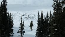
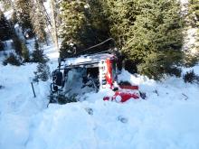
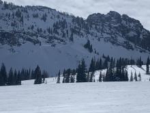
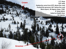
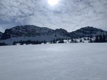
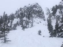
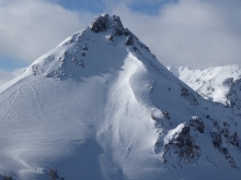
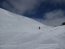
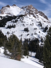
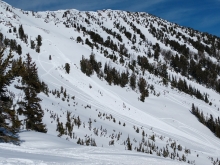
Today’s sunny skies and warm temperatures will increase the wet snow avalanche danger. Slopes getting direct sunshine will begin melting. Signs of instability in the moist surface snow are pinwheels rolling downhill, loose, wet point release avalanches, and sinking past your boot tops in wet snow. This is the first day of sunny skies, exceedingly warm temperatures, and mostly calm wind, a trio of factors that will wet the top foot of snow and increase wet avalanche activity. Ian made a video yesterday about today and tomorrow’s wet avalanche potential. For today, throughout our entire advisory area, the wet snow avalanche danger will rise to MODERATE on all sun exposed slopes.


There is no new snow to report, just wind and mild temperatures. Under partly to mostly cloudy skies mountain temperatures are in the 20sF and wind is blowing W-SW at 20-40 mph and gusts of 55 mph in Hyalite. Today will be partly cloudy and wind will continue to be strong from the southwest. Snow showers this afternoon will drop a trace to 1” of new snow. Tomorrow and Friday look to be warm and sunny giving us a taste of spring.


Last night the mountains received 1-3” of new snow. Winds averaged 15-30 mph from the west to southwest and gusted up to 65 mph at the Flanders weather station in Hyalite Canyon. This morning temperatures are in the teens to low 20s F. Today winds will blow 25-35 mph from the west in the northern ranges and 15-20 mph in the southern ranges. Temperatures will climb into the 20s to low 30s F. This morning Cooke City will receive a 1” of snow with a trace elsewhere before skies clear this afternoon.


Last night westerly wind increased to 15-25 mph with gusts of 30-45 mph. This morning there is no new snow and temperatures are single digits to teens F. Today, temperatures will reach high 20s F with westerly wind at 25-40 mph. Cloud cover will increase through the day, and the mountains will get 1-2” of snow overnight.


Last night the mountains around Hyalite got 5” of snow and 1-3” fell elsewhere. This morning wind is north-northwest at 5-15 mph and temperatures are single digits to high teens F. Today will be partly cloudy with temperatures briefly reaching low 20s F, northerly wind at 5-15 mph and scattered light snow showers. An inch or two of snow is possible before skies clear overnight.


This morning there is no new snow. Mountain temperatures are in the 20s to low 30s F and winds are 20-30 mph out of south and southwest with gusts of 40-50 mph. Today will be mostly cloudy with light precipitation starting this afternoon. There may be a drizzle of rain at lower elevations before it switches over to snow. High temperatures will be in the high 20s and 30s F with moderate southwest winds gusting up to 30-40 mph. A trace to 2” of snow will accumulate by tomorrow morning.

There is no new snow this morning. Mountain temperatures are in the teens and 20s F and winds are SW-NW at 10-20 mph with gusts of 25-35 mph. A beautiful spring day is in store, with sunny skies and temperatures climbing into the 30s F. Gusty west winds will continue through the day. Light snow is on the way tomorrow.


In the last 24 hours, Cooke City picked up 3” of new snow with a trace to 1” falling everywhere else. Under clearing skies mountain temperatures are in the teens and wind is blowing W-NW at 10-20 mph and gusting to 25-40 mph. Today will be sunny and temperatures will climb into the 30sF. Wind will continue to be westerly and gusty. Expect another sunny day tomorrow and snow this weekend.

Yesterday morning a trace to 1” of snow fell in the mountains around Bozeman. At 5 a.m. skies are mostly cloudy, mountain temperatures are near 10-15F, and westerly winds increased to 15-20 mph with gusts of 35 mph. Scattered snowfall through tonight will measure 1-2” by morning and afternoon temperatures will reach the 20s with westerly wind blowing 20-30 mph. Thursday and Friday will be dry and sunny.


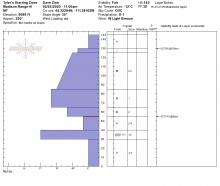
In the last 24 hours, the Bridger and Northern Gallatin Ranges received 15-20” of snow, with 5-8” in the Northern Madison Range and 0-3” in the Southern Ranges and near Cooke City. Winds are 10-15 mph from the west in the northern ranges and from the north in the southern ranges. Mountain temperatures are in the single digits to low teens F. Today, the skies will be partly cloudy, winds will be 5-15 mph from the west to northwest and temperatures will rise into the high teens and low 20s F.
