Good Morning. This is Doug Chabot with the Gallatin National Forest Avalanche Forecast on Wednesday, March 11th at 7:00 a.m. Today’s forecast is sponsored by Yellowstone Arctic Yamaha and Montana State Parks. This advisory does not apply to operating ski areas.
There is no new snow to report this morning, only wind. A moist westerly flow will keep skies partly to mostly cloudy as west to southwest wind blows steady at 15-30 mph with frequent gusts of 40-50 mph. Temperatures are currently in the mid-20s F and will rise into the 40s today. Tonight temperatures will drop back into the 20s, wind will continue and snow will fall. By morning I expect 1-2” of new snow with Cooke City getting 3-4”. Tomorrow looks to be sunny followed by a wintry weekend of snow, cold temps and wind.

All Regions
Today, clouds and wind will keep wet snow avalanches at bay as strong gusts continue to scrape and redistribute snow. Folks that got out yesterday saw wind-loading. Plumes of snow were streaming off the ridges and drifting snow at high elevations (video by GNFAC alumus Eric Knoff). We received many reports from the Bridger Range (details) of wind slabs avalanching both naturally and getting triggered by skiers. Upwards of 12” of snow since Sunday has been blown into wind slabs throughout the forecast area.
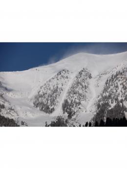
Yesterday, Ian rode into Buck Ridge (video) and found wind-loading (photo) and minor wetting of the snow surface. I took a drive to Cooke City and toured up Woody Ridge. Wind was blowing out of the west scouring slopes and drifting snow at the ridges and in gullies (photo). We were unable to get these drifts to crack, but I did not trust them. In the distance we saw one natural avalanche that was triggered by a cornice fall (photo). Besides our overall concern with wind-loading, our 7-foot deep snowpit revealed no instability (photo, video). We noted sugary facets at the ground are weak and hibernating (snowpit), which is not a problem for now, but like a blister, is annoying and must be watched.
Wind drifts are our primary avalanche concern. Recent avalanche activity is the #1 sign that these drifts are unstable with cracking of wind slabs under your skis or sled a close second. For today, the avalanche danger is rated MODERATE on all wind-loaded slopes and LOW on all others.
If you get out, please send us your observations no matter how brief. You can fill out an observation form, email us (mtavalanche@gmail.com), leave a VM at 406-587-6984, or Instagram (#gnfacobs).
Upcoming Avalanche Education and Events
Our education calendar is full of awareness lectures and field courses. Check it out and plan to attend one or two: Events and Education Calendar.
BILLINGS
TOMORROW, March 12, 1-hr Avalanche Awareness, 6-7 p.m. at The Basecamp.
COOKE CITY
March 13 and 14, Friday and Saturday, (last of the season) Snowpack Update and Rescue Training. Friday, 6:30-7:30 p.m. at the Soda Butte Lodge. Saturday anytime between 10-2 @ Round Lake.
BOZEMAN
March 26, GNFAC Forecaster Chat: Spring Travel and Wet Snow Avalanches, 6-8 p.m. at Uphill Pursuits.
Check out this cool website from the National Snow and Ice Data Center that gives a snapshot of the season’s snowfall across the western US.