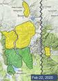
Advisory Archive
Last night wind gusted 40-50 mph before a squall of snow delivered 2-3” near Bozeman, Big Sky and Cooke City with 1-2” near West Yellowstone. This morning temperatures are single digits to teens F and wind is west-northwest at 15-30 mph with gusts of 30-45 mph. Today temperatures will be teens to low 20s F with west-northwest wind at 20-30 mph. Snow showers will continue through tonight. By morning the mountains will have 6-12” of low density snow near Bozeman and Big Sky with 4-6” near Cooke City and 2-3” near West Yellowstone.


This morning there is no new snow, temperatures are teens to 20s F, and wind is westerly at 5-15 mph with gusts to 25 mph. Today will be partly sunny with temperatures reaching high 20s to low 30s F and west wind at 10-25 mph. Clouds increase this afternoon, and snow showers tonight will deliver 3-5” by morning with more snow through tomorrow.

This morning the mountains have no new snow. Temperatures are teens to 20s F. Wind is westerly at 10-20 mph with gusts of 30-40 mph. Today under sunny skies, temperatures will reach high 20s to low 30s F with west wind at 20-30 mph. The next chance for snow is tomorrow night.
High pressure continues. There is no new snow this morning. Today’s weather will be similar to yesterdays, but with temperatures a few degrees higher and a little more wind. A morning inversion has valley temperatures in the single digits F and mountains temps in the teens and 20s F. Southwest winds at 10-20 mph will continue through the day. Temperatures will rise into the high 20s and low 30s F. Except more of the same tomorrow, before the pattern shifts on Sunday.


There is no new snow this morning. Temperatures are in the single digits to teens F and will rise to the high 20s and low 30s F. Winds are 10-20 mph out of the south and west (north near Cooke City). It will be another beautiful day of blue skies and light winds. The next chance for new snow is on Sunday.
The mountains around Bozeman and Cooke City received 1-2” of new snow in the last 24 hours with none for the rest of the advisory area. Mountain temperatures are in the single digits above and below zero F and winds are 5 mph from the west to north. Skies will clear today with temperatures in the low to mid-teens F with light winds at 5-10 mph from the west to north.


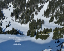
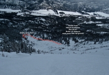
In the last 24 hours, 9” of low-density snow fell on the Bridger Range, 3-5” in the Madison and Gallatin Ranges, and no new snow fell in the mountains around Cooke City and West Yellowstone. Mountain temperatures are in the single digits to teens F and winds are light from the west to southwest at 5-15 mph. Today, lingering flurries will bring up to 1” of new snow before high pressure moves in to the area for the rest of the week. Temperatures will be in the teens F and winds will remain light from the west at 5-15 mph.
In the last 24 hours 2-4” has fallen throughout our forecast area with westerly winds averaging 15 mph and gusting 30-40 mph. Temperatures this morning are in the single digits and will rise into the high teens. Winds will lessen today and scattered snow showers will drop another 2-4” by morning. The rest of the week looks to be sunny with warming temperatures.
Last night, 9”of pixie dust fell around Big Sky, and 4” in the other ranges. Wind is west to southwest averaging 20 mph with gusts of 35 mph. Under cloudy skies temperatures are 15-20F and will rise into the mid-20s. Today will remain breezy with W-SW gusts of 35 mph and snowfall will continue. By morning the mountains will have another 4-6” and 6-10” in Big Sky and Cooke City.


Yesterday morning, 5-7” of snow fell in the mountains around Bozeman and Cooke City, 3-5” in the Madison Range, and no new snow near Lionhead. West winds are 10-25 mph, with gusts of 30-50 mph. Temperatures are in the single digits to teens F. Moderate west winds with strong gusts will continue today. Temperatures will rise into the teens and 20s F under partly to mostly cloudy skies. Snow showers today will become heavier overnight, with 4-6” accumulating by tomorrow morning near West Yellowstone and Cooke City, and 2-4” near Bozeman and Big Sky. Snow will continue through the day tomorrow.