Good Morning. This is Ian Hoyer with the Gallatin National Forest Avalanche Forecast on Friday, March 6th at 7:00 a.m. Today’s forecast is sponsored by Yellowstone Arctic Yamaha and Yellowstone Ski Tours. This advisory does not apply to operating ski areas.
Sunny skies and warm temperatures continue today. There is no new snow this morning. Winds are 10-30 mph out of the south and west with gusts of 30-50 mph. Southwest winds with strong gusts will continue today. Temperatures this morning are in the high 20s to 30s F and will rise into 30s and 40s this afternoon. Tomorrow will start out warm with cooler air and precipitation moving in by tomorrow night.
WET AVALANCHES
The strong March sun and warm temperatures will increase the wet snow avalanche danger today. Yesterday, skiers in the Bridger Range triggered small wet sluffs on steep south facing slopes, but found that most slopes hadn’t warmed up quite enough for wet snow to become an issue (details). I found moist snow at the surface yesterday in the Lionhead area, but no significant wet snow avalanche hazard (video). Today’s slightly warmer temperatures will make wet snow a more widespread issue. Be on the lookout for pinwheels and rollerballs, loose wet point release avalanches, and sinking past your boot tops in slush as signs that the wet snow is becoming unstable. Once you see these signs, it’s time to get off steep slopes or move to the shade. Be particularly alert as you return to trailheads this afternoon on low elevation slopes that will be the warmest and are sheltered from cooling winds. Across our entire advisory area, the wet snow avalanche danger will rise to MODERATE on sun exposed slopes as the day heats up.

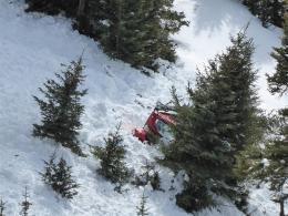
We still can’t trust the snowpack in the northern Gallatin Range. The weak snow near the ground remains unstable. While it’s now been a week since the last avalanche was triggered on this layer by a snowcat groomer in Swan Creek (details), stability tests continue to show lingering instability. On Wednesday, Doug returned to the site of the groomer triggered slide and got unstable results on an adjacent slope (video). On Tuesday, skiers got similar results in thin areas on Mount Ellis. These thin areas are where the snow remains most unstable. Dig and assess the snowpack before committing to steep slopes. For today, triggering avalanches remains possible and the dry snow avalanche danger is MODERATE.
Across the rest of the advisory area, the snowpack is generally stable. Avalanche activity on deeper weak layers had been very limited with just one slide over the last couple weeks (Weather and Avalanche Log). Still, there are weak layers lurking at the bottom of the snowpack and cornices pose a real hazard. Cornices have gotten huge and with the warm temperatures they are failing. Yesterday, near Cooke City a cornice broke and triggered a small wind slab near Sheep Mountain (details). Minimize your time exposed below cornices and give yourself a wide margin if you’re traveling on a corniced ridgeline. For today, triggering dry snow avalanches is unlikely and the danger is rated LOW.
If you get out, please send us your observations no matter how brief. You can fill out an observation form, email us (mtavalanche@gmail.com), leave a VM at 406-587-6984, or Instagram (#gnfacobs).
Upcoming Avalanche Education and Events
Our education calendar is full of awareness lectures and field courses. Check it out and plan to attend one or two: Events and Education Calendar.
COOKE CITY
Every Friday and Saturday, Snowpack Update and Rescue Training. Friday, 6:30-7:30 p.m. at the Soda Butte Lodge. Saturday anytime between 10-2 @ Round Lake.
BOZEMAN
TONIGHT! March 6 and 7, She Jumps Companion Rescue Clinic, Fri 6-8 p.m. and Sat 10a-2p. More info and Register HERE.
BILLINGS
March 12, 1-hr Avalanche Awareness, 6-7 p.m. at The Basecamp.
MSU film student, Nate Kenney made Propagation, a video that profiles GNFAC forecaster Alex Marienthal and highlights what we do at the Avalanche Center. Thanks, Nate! Nice job.