Good Morning. This is Ian Hoyer with the Gallatin National Forest Avalanche Forecast on Friday, March 13th at 7:15 a.m. Today’s forecast is sponsored by Yellowstone Ski Tours and Montana State Parks. This advisory does not apply to operating ski areas.
Yesterday morning, the Bridger Range picked up 1” of new snow, with only a trace across the rest of the advisory area. Overnight, moderate winds shifted from west to east in the Bridger Range. Elsewhere, winds are 10-20 mph out of the south and southwest this morning, but will shift to the southeast today. Temperatures this morning are in the single digits and low teens F. High temperatures will be in the 20s F. Clouds will build this morning with snow showers possible, but no significant accumulations. Heavier snowfall is on the way tomorrow and tomorrow night.

All Regions
The snowpack is generally stable. However, there are still some avalanches concerns worth watching out for, primarily wind drifted snow.
Strong winds earlier this week formed wind slabs that were breaking naturally as well as being triggered by skiers and riders (photo, details). At this point, those wind drifts have mostly bonded and gained enough strength to be of limited concern, but be on the lookout in case you find one that hasn’t glued on yet (video). You’re most likely to find poorly bonded drifts where they sit over a hard crust that formed last weekend. With winds shifting to a somewhat unusual direction today (east and southeast), we could see a little bit of new wind loading on atypical slopes. Pay attention to the feel of the snow beneath your feet. If the snow suddenly feels harder and hollow, you’ve found a wind slab and need to check how well it’s bonded before getting onto steep slopes. Shooting cracks are a clear sign that it remains unstable.
With cooler temperatures and cloudy skies, wet avalanches concerns are on hold for the moment. The weak layers at the ground are also dormant and not a significant concern until we get a big warmup or a huge loading event.
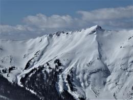
As the snowpack becomes more stable, it is reasonable to step out your terrain choices, but that should be done cautiously and with intention. Yesterday, near the Throne in the Bridger’s I sought out a non-wind loaded slope, felt good about stability, and was comfortable getting into avalanche terrain (video). In contrast, just a few miles to the south, touring north of Bridger Bowl, Dave considered skiing a line off the ridge, but decided against it because of recent wind loading. LOW danger is not carte blanche to ride any and all slopes. Be on the lookout for recent wind loading and (unexpected) signs of lingering instability.
Large avalanches are unlikely and the avalanche danger is LOW.
If you get out, please send us your observations no matter how brief. You can fill out an observation form, email us (mtavalanche@gmail.com), leave a VM at 406-587-6984, or Instagram (#gnfacobs).
Upcoming Avalanche Education and Events
Our education calendar is full of awareness lectures and field courses. Check it out and plan to attend one or two: Events and Education Calendar.
COOKE CITY
TONIGHT and TOMORROW! March 13 and 14, Friday and Saturday, (last of the season) Snowpack Update and Rescue Training. Friday, 6:30-7:30 p.m. at the Soda Butte Lodge. Saturday anytime between 10-2 @ Round Lake.
BOZEMAN
March 26, GNFAC Forecaster Chat: Spring Travel and Wet Snow Avalanches, 6-8 p.m. at Uphill Pursuits.
Check out this cool website from the National Snow and Ice Data Center that gives a snapshot of the season’s snowfall across the western US.