Advisory Archive
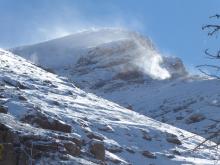
By 5 a.m. 10-12” fell around Cooke City, West Yellowstone and the southern ranges, 4” around Big Sky and 1-2” in the Bridger Range and Hyalite. In the last 24 hours westerly winds averaged 30 mph and gusted into the 70s. The storm will drop another inch or two in the south before it ends this morning. The sun may poke out today and mountain temperatures will rise into the high 20s with strong westerly wind blowing 20-30 mph and gusting to 50 mph. A few more inches of snow will fall on Sunday around West Yellowstone and Cooke City.


Since Monday, intermittent snow showers brought 1-6” of new snow, favoring the mountains around Bozeman. Winds have been westerly at 15-30 mph with gusts up to 50 mph.
Snowfall will begin this afternoon, with up to 8” falling near West Yellowstone and Cooke City by tomorrow morning and 1-3” near Bozeman and Big Sky. Strong west winds are expected today and tomorrow as the front moves through. Another small pulse of snow favoring West Yellowstone and Cooke City will move through on Sunday. Mountain temperatures will remain below freezing in the mountains over the weekend and then rise a bit next week.
In the last 24 hours, the mountains around West Yellowstone and Cooke City received 4” of new snow with 1-2” in the mountains near Bozeman and Big Sky. Winds are 10-15 MPH from the west with mountain temperatures in the single digits above and below zero F.
Snow will return late Tuesday morning with 2-4” falling by Thursday. Winds will be 5-10 MPH from the west and pick up to 10-20 MPH on Tuesday with the storm. Mountain temperatures for the week will peak in the teens and 20s F.


This morning the mountains near Bozeman, Big Sky and West Yellowstone have 3-5” of new snow, and near Cooke City has 9”. Wind is primarily out of the east at 5-20 mph with gusts to 45 mph. Temperatures are in the teens to low 20s F and will drop to the single digits tonight. Today wind and snow will continue. Wind will shift to a northerly direction at 10-20 mph with 3-6” of snow possible by tomorrow morning.
Wind and warmer temperatures were the stories of the week with the mountain ranges barely freezing for the last several days. Winds calmed in the previous 24 hours, but this week they blew from the southwest to the northwest with gusts reaching 45 to 50 MPH. There was no new snow.
Sunny and dry conditions will persist for the weekend. The most notable weather will be moderate to strong winds blowing 20-35 MPH from the west Friday afternoon into Saturday morning. Temperatures will range from the 20s to near 50 F for the weekend with no new snow in the near-term forecast.

1-3” of new fell yesterday morning before snowfall tapered off around noon. Temperatures this morning are bitterly cold (below zero F) and will only rise into the single digits F today. Winds are generally moderate out of the east, except on the Bridger Ridge where they are holding steady in the high 30s mph and gusting into the high 50s mph.
Winds will shift to the north and then west tonight and tomorrow. Temperatures will rise steadily each day through the middle of the work week. Sunny and dry conditions will prevail for the next week.

Since Thursday morning 3-6” of snow fell in the mountains, most of it last night. At 5 a.m. temperatures are in the high teens to 20s with west to southwest wind at 20 mph and gusts to 45 mph. Today will be stormy with temperatures in the 20s and ridgetop winds 20-40 mph from the west to southwest. By tonight another 6-8” will fall in the northern mountains and Cooke City, with 3-6” falling in the southern ranges and mountains around West Yellowstone. Sunday looks to be sunny.


Cold and snowy weather is here and will stay through the weekend. Last night the mountains near Bozeman and Cooke City got 4-8” of snow, and 2-3” fell near Big Sky and West Yellowstone. This morning temperatures are single digits to teens F and wind is 5-15 mph out of the west-northwest. Today temperatures will be in the teens F with east to northeast wind at 5-15 mph. Skies will be partly sunny through Friday afternoon. Heavy snow is expected Friday night with 8-12” possible by Sunday morning, and temperatures will be in the single digits to teens F with gusty west-southwest winds.
The mountains are starting to turn white. 8 to 17” of wet, heavy snow fell this weekend at lower elevations in the mountains around Bozeman and Cooke City, totaling 1.7” to 2.8” of Snow Water Equivalent. At higher elevations, 1-2 feet of new snow likely fell. Less than 6” fell around Big Sky and West Yellowstone. Winds have been westerly at 15-25 mph with gusts up to 50 mph.
Light snow flurries will continue today and tomorrow without much accumulation (rain may fall at lower elevations). More substantial snowfall is expected starting Wednesday and continuing through the weekend.
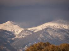
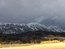
Winter has been courteous and allowed a proper fall to take place in southwest Montana. The mountain tops recently got their first coat of white, and the weather pattern is starting to shift to cooler temperatures with a few inches of snow expected this weekend. For current weather data check our weather stations in Cooke City and Hyalite, as well as Bridger Bowl’s weather stations, and SNOTEL sites throughout our advisory area.