Advisory Archive

Yesterday morning it snowed 2-3 inches near West Yellowstone and Cooke City, while the mountains around Big Sky and Bozeman stayed dry. This morning temperatures are in the teens and low 20s F. Winds are southwest and west at 10-25 mph with gusts of 30-45 mph. Clouds will break up this morning leaving us with mostly sunny skies. Winds today will be 10-25 mph out of the southwest. Temperatures will rise into the mid-30s F. A dusting of snow is possible overnight.

After a couple cold wintery days, spring is on its way back today. We’ll have mostly sunny skies and mountains temperatures a bit warmer than yesterday, rising to around 30 F. This morning, there is no new snow and temperatures are in the single digits and low teens F. Winds are 5-20 mph out of the southwest and west. Light to moderate southwest winds will continue today. Snow showers are possible this afternoon and tonight, but expect less than an inch of new snow accumulation.


Winter’s grip is strong. Mountain temperatures dropped to the single digits last night with a bitter east to northeast wind averaging 10 mph and gusting to 30 mph. Yesterday morning another 1-2” of snow fell before the storm ended. Today, skies will become partly cloudy, temperatures will rise into the high 20s F and wind will shift to the northwest at 10-20 mph. No snow is expected, just chilly temperatures and a biting east wind.


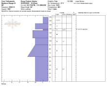
In the last 24 hours, the mountains received 10-13” of new snow. Winds were 10-20 mph from the west with strong gusts up to 65 mph at the Lulu Pass weather station. In the Bridger Range winds were 5-10 mph from the west. This morning mountain temperatures are in the upper single digits to mid-teens F. Today, high temperatures will be around 20 F, winds will be from the west at 10-15 mph before swinging northeast in the evening. There will be periods of partly cloudy skies this afternoon. By morning the southern ranges will get an additional 4-6” of snow with 2-4” in the northern ranges.

This morning the mountains near West Yellowstone and Cooke City have 5-8” of dense new snow with 2-3” near Bozeman and Big Sky. Overnight, southwest wind gusts hit 30-60 mph. This morning wind is 5-15 mph with gusts to 30 mph and temperatures are high 20s F. Today wind will increase to 20-35 mph and temperatures will reach low 30s F. Snow showers will drop 4-6” with possible thunder this afternoon, and another 3-5” of snow tonight.
This morning the mountains near West Yellowstone, Cooke City and Big Sky have 1-2” of snow. Elsewhere there is no new snow. Yesterday southwest wind gusted 20-30 mph then decreased overnight. This morning temperatures are 20s to low 30s F with southwest wind at 5-15 mph. Today temperatures will reach high 30s to low 40s F under partly sunny skies. Southwest wind will increase this afternoon to 20-30 mph. Light snow showers are possible today with more snow tonight through Wednesday. By tomorrow morning 3-5” of snow is possible near West Yellowstone and Cooke City with 1-3” elsewhere.


Yesterday morning the mountains got an inch of snow. This morning temperatures are high teens to 20s F with west-southwest wind at 5-20 mph. Today, under partly sunny skies, temperatures will reach mid-30s F with southwest wind at 15-25 mph. Clouds will increase this afternoon with a trace to an inch of snow overnight. More snow is expected through Wednesday.
An inch of new snow fell overnight near Big Sky while most areas stayed dry. Winds are out of the west at 10-15 mph with gusts of 30 mph. Temperatures are in the teens and 20s F. Today will be partly cloudy with snow showers possible. Winds will be 10-20 mph out of the southwest and west. Temperatures will rise to around 30 F. An inch or two of new snow will accumulate by tomorrow morning.
There is no new snow this morning. Winds have been westerly at 15-20 mph with gusts to 30 mph. Temperatures are in the single digits to teens F. Scattered clouds this morning will build through the day, with snow showers possible this afternoon. Winds will be 10-15 mph out of the southwest and west. Mountain temperatures will rise to around 30 F. Light snowfall tonight won’t bring more than dusting of new snow.

In the last 24 hours Cooke City, Hyalite and Big Sky received 5-6” while everywhere else got 2-3”. Wind has been westerly at 5-10 mph with gusts of 20 mph. Skies are clearing this morning but will remain partly cloudy in the southern ranges. Wind will remain light and mountain temperatures may rise into high 30s. No snow is expected in the next few days.