Good Morning. This is Ian Hoyer with the Gallatin National Forest Avalanche Forecast on Saturday, March 14th at 7:00 a.m. Today’s forecast is sponsored by Yellowstone Arctic Yamaha and Montana Alpine Guides. This advisory does not apply to operating ski areas.
Overnight, a trace to an inch of new snow fell. Strong winds are out of the southwest to east up with gusts of 30-50 mph. Temperatures are in the teens and low 20s F. Strong winds will continue today out of the south and southeast. Snowfall will start this morning and intensify this afternoon, with 1-3” likely by nightfall. By tomorrow morning, expect 6-12” in the south and 3-6” in the northern mountains. Snow will continue through the day tomorrow.

All Regions
The dusting of new snow this morning isn’t enough to elevate the avalanche danger. However, depending on how fast snow accumulates, we may see an increased hazard by this afternoon.
The snowpack is generally stable. Yesterday, Dave rode near Cooke City and covered his bases by avoiding slopes below big cornices but otherwise felt good about stability (video). Cornices have grown huge and can break off unpredictably. Minimizing your time beneath them is always a good idea, but especially with the combination of low visibility and active loading that we’ll have today.
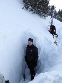
The wind slabs that formed earlier this week are mostly bonded and of minimal concern. However, yesterday, skiers in Cooke City dug a snowpit, found a reactive wind slab, and backed off the wind loaded slope they had been thinking about skiing. Follow their example by searching for signs of instability and backing off if you find them.
As snow falls today it will be drifted by strong winds. Fresh wind slabs will build through the day. As they grow they will be easily triggered by skiers or riders. The slabs will start off thin, but may become deep enough to cause issues by later in the afternoon. Adjust your plans if you find fresh wind slabs more than a few inches thick.
Large avalanches are unlikely and the avalanche danger is LOW this morning. Danger may rise to MODERATE by this afternoon on wind loaded slopes if heavy snowfall develops more quickly than expected.
If you get out, please send us your observations no matter how brief. You can fill out an observation form, email us (mtavalanche@gmail.com), leave a VM at 406-587-6984, or Instagram (#gnfacobs).
Upcoming Avalanche Education and Events
Our education calendar is full of awareness lectures and field courses. Check it out and plan to attend one or two: Events and Education Calendar.
COOKE CITY
TODAY! March 14 (last of the season) Rescue Training at Round Lake stop by anytime between 10-2.
Ever confused by a term we use in a forecast or a video? The Avalanche Encyclopedia is a great resource that has definitions for a whole lot of avalanche related terms.