Good Morning. This is Doug Chabot with the Gallatin National Forest Avalanche Forecast on Sunday, March 8th at 7:30 a.m. Today’s forecast is sponsored by Cooke City Motorsports and Map Brewing. This advisory does not apply to operating ski areas.
Last night temperatures dropped below freezing, wind died down and snow began falling. At 6 a.m. there is 7” of new snow in the Bridger Range, 2” in Cooke City and 4-5” everywhere else. Wind is from the west at 10-25 mph and mountain temperatures are in the 20s F. This morning another inch will fall and then skies will become partly sunny as mountain temperatures rise to near 40F.

All Regions
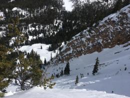
I was happy to see temperatures cold enough to make snow instead of rain. Four to seven inches of snow is measuring about .5” of snow water equivalent—enough to improve the skiing and riding conditions yet not enough of a load to increase the dry snow instability. Conditions will change rapidly today when sunshine and above freezing temperatures moisten the new snow and trigger wet avalanches. These slides will be confined to slopes getting sunshine. Yesterday, small wet avalanches were seen around Cooke City (photo) and skiers triggered a slab avalanche (likely wet) in Hyalite on an 8700’ east-facing slope to the north of Mt. Blackmore. They kicked off a cornice which broke 150’ wide in the old snow and ran 1,000’ downslope (photo, video and details). Ian was nearby on Mt. Ellis and found wet snow to the ground on a similar aspect and elevation (video). Although colder weather prevails in the next few days, deeply buried wet snow will not refreeze quickly.
Wet avalanches are a function of water melting bonds and weakening the snowpack structure. Dry avalanches are a function of slopes getting a critical load that breaks a weak layer. We load slopes by skiing and riding on them, from snowfall and from cornices falling. Right now cornices are huge and easy to break. There is weak, sugary snow at the bottom of the snowpack in all our ranges and a cornice fall could trigger an avalanche on this layer. Give these overhangs of snow a wide berth if you travel along a ridge and avoid being underneath them.
If you step off your skis and sink to the ground in wet snow, like Ian did yesterday, then you should back off your objective. This is a sign the snowpack has lost strength. Wet snowpacks are unpredictable and could avalanche as the skiers in Hyalite discovered. If the snow is dry, then slopes will be generally stable. For today the dry snow avalanche danger is rated LOW. However, the wet snow avalanche danger will increase to MODERATE on slopes getting direct sunshine.
If you get out, please send us your observations no matter how brief. You can fill out an observation form, email us (mtavalanche@gmail.com), leave a VM at 406-587-6984, or Instagram (#gnfacobs).
Upcoming Avalanche Education and Events
Our education calendar is full of awareness lectures and field courses. Check it out and plan to attend one or two: Events and Education Calendar.
COOKE CITY
March 13 and 14, Friday and Saturday, (last of the season) Snowpack Update and Rescue Training. Friday, 6:30-7:30 p.m. at the Soda Butte Lodge. Saturday anytime between 10-2 @ Round Lake.
BOZEMAN
March 26, GNFAC Forecaster Chat: Spring Travel and Wet Snow Avalanches, 6-8 p.m. at Uphill Pursuits.
BILLINGS
March 12, 1-hr Avalanche Awareness, 6-7 p.m. at The Basecamp.
Check out this cool website from the National Snow and Ice Data Center that gives a snapshot of the season’s snowfall across the western US.