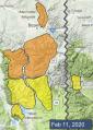
Advisory Archive

Last night winds picked up with gusts of 30-60 mph out of the south and west. These strong and gusty winds will continue today as a cold front passes through. Temperatures are in the teens to mid-20s F. and will stay fairly constant through the day under mostly cloudy skies. There is no new snow this morning. Periods of snowfall today will leave 1-2 inches by this afternoon and 2-4 inches by tomorrow morning.


In the last 24 hours, low density pixie dust totaled 6” in the Bridger Range and 2” everywhere else except West Yellowstone. Wind has been light from the west at 5-10 mph with 20 mph gusts. Temperatures this morning are in the high single digits and will warm to the mid-20s under clearing skies. Wind will increase tonight from the west at 15-25 mph and no new snow is expected until tomorrow

Last night 5” fell from the Bridger Range to Hyalite and Big Sky (with 10” at Bavaria). The southern mountains and West Yellowstone got 3-4” and Cooke City received 6”. Temperatures are in the low teens to single digits and wind has decreased from gusts of 50 mph yesterday to an average of 10-25 mph from the west to north today. Another inch may fall this morning, then skies will turn mostly cloudy and clear tomorrow.


This morning temperatures are in the single digits above and below zero, winds are 15-20 mph from the west in the northern ranges and in West Yellowstone and Cooke City winds will be 5-15 mph from the south. 1” of new snow fell yesterday morning before it tapered off. Today, winds will pick up in the northern ranges from the west at 25-35 mph. Near Cooke City and West Yellowstone winds will be 15-25 mph from the west to southwest. High temperatures will be in the teens to low 20s F. Tonight the mountains around Cooke City will get 4-6” of new snow, around Bozeman and Big Sky 3-5” and West Yellowstone will get a trace to 2”.


At 6 am the Bridger Range has 12” of new low density snow, Hyalite and Big Sky have 5-9”, Cooke City has 2” and near West Yellowstone zero. Temperatures are single digits to teens F and wind is northwest at 5-15 mph with gusts to 20 mph. Today temperatures will be teens F with northerly wind at 10-25 mph. Snow showers will end later this morning with an additional 2-4” possible near Big Sky and Bozeman.

Since yesterday morning 10” of new snow fell in Hyalite, 5” in the Bridger Range, 2-4” near Big Sky and Cooke City and zero near West Yellowstone. Yesterday west-northwest wind was 15-25 mph with gusts of 40-50 mph. This morning wind decreased to 5-15 mph and temperatures are single digits to low teens F. Today temperatures will reach mid-teens to low 20s F under mostly sunny skies. Wind will be north-northwest at 5-15 mph and increase to 15-25 mph this afternoon. Expect snow overnight to drop 3-5” near Bozeman and Big Sky and 1-2” elsewhere by morning.

This morning there are 6” of new snow in Cooke City and 2-3” across the rest of the advisory area. Southwest and west winds are 10-30 mph with gusts of 30-50 mph overnight. Temperatures this morning are in the 20s F. A cold front today will bring snowfall, strong winds, and temperatures dropping though the day. Expect 6-8” by tomorrow morning near Bozeman, Big Sky and Cooke City and 2-4” near West Yellowstone.
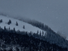

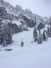
Our largest storm of the year continues. At 6 a.m., 24-hour snowfall totals are 10-14” near Bozeman and West Yellowstone, with 14-24” near Big Sky, and 4” in Cooke City. The bulk of that snow fell yesterday during the day and it is snowing again this morning. Winds are 10-20 mph out of the west with gusts of 40 mph. Temperatures are in the teens to low 20s. Snowfall will continue today with a brief break this evening before another pulse hits overnight. By tomorrow morning an additional 6-10” will fall with strong W-NW winds and mountain temperatures in the 20s to low 30s F.

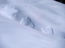
We are in the midst of a nice winter storm. At 6 a.m., the 24-hour snowfall is 10-15” from West Yellowstone to the Bridger Range, and 6” in Cooke City. Most of it fell last night. Wind has picked up and is blowing strong out of the W-NW at 20 mph with gusts of 40 mph. Snow will continue into Friday afternoon. By tomorrow morning another 12-18” will have fallen with strong W-NW wind and mountain temperatures near 20F. Today is your chance to lay a little groundwork so you can take tomorrow off. A few sniffles and well-timed cough equals a three day weekend of Pow!


Last night a northwest flow dropped 10” in the Bridger Range, 8” around Big Sky and 2” everywhere else. Ridgetop wind is blowing westerly at 15-20 mph with gusts of 30-40 mph. Mountain temperatures this morning range from a few degrees below zero to single digits. Today and tonight will be snowy and windy with westerly gusts hitting 40 mph. By morning I expect 8-12”of snow in most areas with Cooke City getting closer to 6”.