Good Morning. This is Doug Chabot with the Gallatin National Forest Avalanche Forecast on Monday, February 17th at 6:45 a.m. Today’s forecast is sponsored by Swiss Fit Montana and Your Montana Chevy Dealers. This forecast does not apply to operating ski areas.
In the last 24 hours 2-4” has fallen throughout our forecast area with westerly winds averaging 15 mph and gusting 30-40 mph. Temperatures this morning are in the single digits and will rise into the high teens. Winds will lessen today and scattered snow showers will drop another 2-4” by morning. The rest of the week looks to be sunny with warming temperatures.

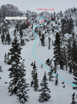
In the northern mountains there has been a lot of natural avalanche activity. Most slides broke Friday and Saturday. Many were large, deep and broke trees. Our Photos page and Avalanche Activity page are bursting at the seams with avalanches. Some notable ones:
- A huge avalanche in Divide Basin,
- Many avalanches on and around Mt. Blackmore, Elephant Mountain and Alex Lowe Peak,
- A large avalanche in Bear Basin,
- An avalanche yesterday morning in Wolverine Bowl, north of Bridger Bowl.
Most of the avalanches were on heavily wind-loaded terrain, but not all. Some were triggered by cornice falls, and the larger slides broke at the ground on the sugary facets that formed in November. What is astonishing is how these slopes did not go with the big storm a week ago, and instead broke with just a few more inches of snow and wind. Like the proverbial ‘straw that broke the camel’s back’ we just witnessed how every snowpack has its breaking point.
Natural activity will become more unlikely today, but triggering slides remains very real. Terrain that folks might normally think of as “safe” are questionable, especially low elevation hills. These have a thin snowpack consisting of very weak snow now capped with a couple feet of snow. Avalanches on Chestnut Mountain, near Lick Creek, and Wheeler Mountain are evidence that slopes near History Rock, Mt Ellis, Beehive Basin and other low lying areas are untrustworthy. The one word avalanche danger, Moderate or Considerable, does not capture the overall seriousness of traveling in avalanche terrain.
Avoid wind-loaded slopes. Avoid steep slopes in general, because after this many avalanches it’s hard to justify. Time will calm things down, but today remains heads-up. On any slope with a wind-load, triggering avalanches is likely and the danger is rated CONSIDERABLE. On all others, triggering avalanches remains possible and the danger is rated MODERATE.

In the southern mountains, including West Yellowstone and Cooke City, there has been new snow and wind most of the last 7 days. A snow biker on Saturday triggered an avalanche in Taylor Fork (photo), and a large avalanche on the east face of Woody Ridge, south of Cooke City, avalanched on Friday. Dave is in Cooke City. His concerns are two-fold: winds have drifted snow that could avalanche, and weak, sugary snow at the ground still has the potential to slide. He could feel the unconsolidated snow at the ground when he probed into the 10-foot deep snowpack (video). His concerns mirrored mine in Lionhead on Saturday (video). For today, avalanches are still possible and the danger is rated MODERATE. Do not get on steep slopes or wind-loaded slopes if you get cracking or collapsing.
If you get out, please send us your observations no matter how brief. You can fill out an observation form, email us (mtavalanche@gmail.com), leave a VM at 406-587-6984, or Instagram (#gnfacobs).
Upcoming Avalanche Education and Events
Our education calendar is full of awareness lectures and field courses. Check it out and plan to attend one or two: Events and Education Calendar.
COOKE CITY
Every Friday and Saturday, Snowpack Update and Rescue Training. Friday, 6:30-7:30 p.m. at the Soda Butte Lodge. Saturday anytime between 10-2 @ Round Lake.
BOZEMAN
March 4, 1-hr Avalanche Awareness. 6-7 p.m. at REI.
WEST YELLOWSTONE
February 22, 1-hr Avalanche Awareness. 7-8 p.m. at West Yellowstone Holiday Inn.
The recent avalanches have been large and some have occurred in unusual locations. Our Photos page and Avalanche Activity page are bursting at the seams with avalanche reports.