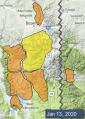
Advisory Archive
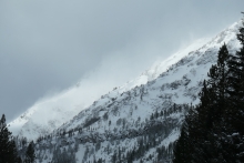
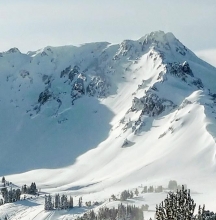
Squalls yesterday and last night dropped 9” in the Bridger Range, 6” around Cooke City and 2-4” everywhere else. Under partly cloudy skies mountain temperatures are 0F with west to southwest wind blowing steady at 20 mph and gusting to 40 mph. Today will be mostly clear, temperatures will warm to 20F and westerly wind will remain strong and lessen tonight.


The mountains around West Yellowstone and Cooke City received 3-5” of snow in the last 24 hours, Big Sky to the north remained dry. Temperatures were 5-15 F degrees and winds were 10-20 mph from the southwest. Today, West Yellowstone and Cooke City will get 4-8” of snow with 2-3” in the northern ranges. Winds will be 15-30 mph from the southwest and temperatures will be in the teens.
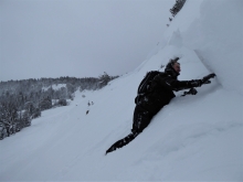
Since yesterday morning new snow amounts range from zero in Hyalite to 12” in the mountains near West Yellowstone. The southern Madison Range and Cooke City got 4-7”, Big Sky got 3-5", and the Bridger Range got 3” near the ski area and 7-10” in the north. Overnight south-southwest wind increased to 15-30 mph with gusts of 30-50 mph. This morning temperatures are single digits to teens F and will remain cold today with highs in the teens F. Wind will shift westerly at 15-30 mph. Light snow is expected today with heavier snowfall overnight and tomorrow. By tomorrow morning 6-10” is possible near West Yellowstone and Cooke City with 2-4” elsewhere.
Since yesterday morning the mountains near Bozeman got 1-2” of snow. Elsewhere got 3-4” with the Yellowstone Club showing 7” of low density snow. Wind has been west-southwest at 10-20 mph with gusts to 30 mph. This morning temperatures are single digits to teens F. Today temperatures will be low teens to mid-20s F with southwest wind at 15-30 mph. Expect light snow today with increased snowfall intensity overnight. By morning 4-6” of new snow is possible near Bozeman and 6-10” near Big Sky, West Yellowstone and Cooke City.

Overnight, the Yellowstone Club picked up 12” of new snow, 6” fell at Big Sky, and 1-2” across the rest of the advisory area. Winds are 20-30 mph out of the south and west, with gusts up to 50 mph. Temperatures are in the single digits to teens F. Winds today will be 20-30 mph from the southwest. An inch or two of snow will fall by this afternoon with 4-6” possible by tomorrow morning, favoring the southern ranges and Cooke City.


Since yesterday morning, 4-7” of new snow fell near Bozeman and near Big Sky with 1-2” near West Yellowstone and Cooke City. Winds are out of the west at 15-20 mph with gusts of 35 mph. Mountain temperatures are in the single digits above and below zero F. Winds today will be 15-25 mph from the southwest with gusts to 35. Snowfall tonight will bring 2-4” by tomorrow morning.

At 6 a.m. it is snowing in the mountains. Bridger Bowl and the Yellowstone Club have 8” of snow, 3-4” at Big Sky, Taylor Fork and Cooke City, and 1” in Hyalite and West Yellowstone. Wind is southwest at 10-15 mph with gusts of 35 mph and mountain temperatures are 10-15 F. Scattered showers will bring 2-4” by tomorrow morning with southwest wind at 15-25 mph. Friday looks to be sunny and more snow is expected this weekend.

In the last 24 hours Cooke City picked up 6” of snow and 1” fell at West Yellowstone. Wind is from the southwest at 15-20 mph with gusts of 45 mph. Mountain temperatures are in the high teens to low 20s F. Today will be cloudy with scattered snow showers, decreasing southwest wind and steady temperatures. By tomorrow morning the mountains will have 1-2” with Cooke City seeing 2-4”. Snow is expected to continue into Friday.

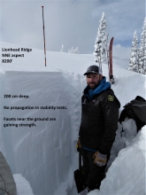
In the last 24 hours, snow favored the southern ranges with 8-10” in Cooke City and West Yellowstone, 2-3” around Big Sky and trace elsewhere. Winds are 10-20 mph from the west to southwest in the southern mountains and 15-30 mph in the northern ranges and temperatures are in the teens to low 20s F. Today, winds will be 25-35 mph from the southwest with temperatures in the 30s F. Cooke City will receive an additional 6-8” of snow by Wednesday morning, Lionhead will get 1-3” and the other ranges will get a trace.
Yesterday the mountains got 1-2” of new snow. Overnight west-southwest wind increased to 25-40 mph with gusts of 40-55 mph. This morning temperatures are single digits to mid-teens F. Today temperatures will be teens to low 20s F with west wind at 25-50 mph. Snow today and tonight will favor the mountains near Cooke City with 8-10” possible by morning. The mountains near West Yellowstone will get 3-5”, and near Bozeman and Big Sky will get 1-2”.