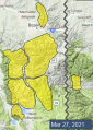
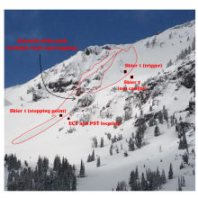
Advisory Archive
Big Sky picked up 3-10” of low density new snow, while other areas only received a trace-1”. Strong winds are out of the west and northwest, gusting 30-45 mph. Temperatures are in the teens and 20s F. Westerly winds will back off a bit today, only gusting into the 20s. Temperatures will rise into the 30s and 40s F. There will be a few lingering snow showers this morning before skies begin to clear.

Since yesterday morning, 1-3” of snow fell across most of the advisory area, with 5” in Hyalite and 7-9” of low density snow at the Yellowstone Club. Winds are 5-10 mph out of the north and east, with gusts of 25 mph in the Bridger Range where the winds shifted to the west early this morning. Winds will shift westerly across the rest of the advisory area and remain light this morning, before increasing a bit later this afternoon. Temperatures are in the teens and 20s and will rise into the 20s and low 30s. Snow flurries today and tonight won’t amount to much accumulation.


Snowfall began late last night and at 5 a.m. the Bridger Range is measuring 7”, Yellowstone Club has 10” and 2-3” fell everywhere else. Wind is averaging 10-15 mph with gusts of 25-30 mph from the south to west and temperatures are in the teens. Snow and wind will continue today. By morning I expect 6-8” in the northern ranges and 4-6” in the southern mountains.

Early yesterday morning 1-2” fell around Bozeman and Big Sky before the storm ended. This morning skies are clear, mountain temperatures are in the single digits and wind is west to southwest at 10-20 mph with gusts of 35 mph in the Bridger Range. Wind will remain the same and skies will cloud up this afternoon with temperatures reaching the mid-thirties F. Snow showers tonight will drop 1-2” by morning.


Mountain temperatures are in the teens F with 5-15 mph winds from the northwest to north. There is 7-8” of new snow in the Bridger Range and around Big Sky with 3-4” in the other ranges. Today, high temperatures will be in the 20s F with 5-10 mph winds from the north. The mountains around Bozeman, Big Sky and Cooke City will get 2-4” of new snow with 1” near West Yellowstone.


Mountain temperatures are in the teens F with 10-20 mph winds from the west to southwest, and there is 1-3” of new snow in the mountains around Bozeman, Big Sky, and West Yellowstone. Today, high temperatures will be around 30 degrees F with 10-20 mph winds from the southwest shifting to the northwest this evening. By morning, the Gallatin and Madison Ranges will get 4-6” of new snow with 2-4” in West Yellowstone, Cooke City, and the Bridger Range.

Since yesterday morning the mountains near Cooke City and West Yellowstone got 8-10” of heavy new snow, and near Bozeman and Big Sky got 3-5”. Overnight, wind increased to 10-15 mph with gusts of 25-35 mph, and this morning temperatures are teens to low 20s F. Today will be partly sunny with increasing clouds this afternoon. Temperatures will reach 20s F with west-northwest wind at 5-15 mph. There is a chance for a trace to 1” of snow tonight with more snow expected through tomorrow night.
This morning the mountains near Bozeman, Big Sky and West Yellowstone have 6-8” of new snow with 2” near Cooke City. Temperatures are 20s to low 30s F and wind is west-southwest at 5-15 mph. Today temperatures will be 20s to low 30s F with west-northwest wind at 5-15 mph. Steady snowfall could deliver 3-6” by this afternoon, and another 5-8” by tomorrow morning with potentially more near Cooke City and West Yellowstone.


Skies are clear this morning with mountain temperatures around freezing. Winds are 10-15 mph out of the south and west, with gusts of 20-35 mph. Breezy winds will continue as skies cloud up today. Precipitation will start this afternoon or evening. With high temperatures in the 30s F, we may see some rain before switching over to snow this evening. By tomorrow morning, 4-8” of snow will fall around West Yellowstone, with a trace to 3” around Bozeman, Big Sky, and Cooke City.


Mountain temperatures are in the low to mid 20s F this morning after hitting the mid 40s F yesterday. Skies are clear and winds are southwest at 10-25 mph. Today will be sunny, breezy and a few degrees warmer than yesterday. Winter is not over and my lawn chairs will hopefully get some snow on them over the weekend.