Good Morning. This is Dave Zinn with the Gallatin National Forest Avalanche Forecast on Monday, March 22nd at 7:15 a.m. Today’s forecast is sponsored by Cooke City Motorsports and Beartooth Powder Guides. This forecast does not apply to operating ski areas.
Mountain temperatures are in the teens F with 10-20 mph winds from the west to southwest, and there is 1-3” of new snow in the mountains around Bozeman, Big Sky, and West Yellowstone. Today, high temperatures will be around 30 degrees F with 10-20 mph winds from the southwest shifting to the northwest this evening. By morning, the Gallatin and Madison Ranges will get 4-6” of new snow with 2-4” in West Yellowstone, Cooke City, and the Bridger Range.

All Regions
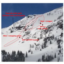
Since Friday, the mountains received 10-17” of heavy snow, equal to 0.9-1.6” of snow water equivalent (SWE). Winds increased to 10-20 mph from the west to southwest, transporting soft snow into unstable drifts. Our primary avalanche concerns today exist within this new and wind drifted snow. Yesterday, a group of skiers triggered an avalanche that broke 10” deep about 150’ above them, catching one person and carrying them 250 vertical feet down Alex Lowe Peak (details and photos). As they returned to the trailhead, they saw another group trigger an avalanche on the east face of Mount Blackmore (details). Thankfully, no one was injured in either event, but it was a close call. On Saturday, a group near Hyalite Peak triggered a 4” deep, 150’ wide avalanche from 150’ away (photo and info). While small relative to February’s deep slab avalanches, none of these slides should be underestimated especially in steep or extreme terrain.
Assess the stability of the interface between old and new snow by digging down 2’ and performing quick extended column tests remembering that it will change at different aspects and elevations. Yesterday at Buck Ridge, we found a weak layer of near-surface facets that consistently failed in our stability tests after digging four other pits along the way with stable results (video). The new snow is generally bonding well, but in areas with a wet snow interface (Ian’s Bacon Rind video) or a weak, faceted interface, it is not. Watch Alex’s video from the Bridger Range and Doug’s videos from the Centennial Range and Cooke City to see how it is playing out regionally.
Today, recent and ongoing snowfall with increasing wind make human-triggered slides possible. The danger is rated MODERATE.
If you get out, please send us your observations no matter how brief. You can submit them via our website, email (mtavalanche@gmail.com), phone (406-587-6984), or Instagram (#gnfacobs).
Upcoming Avalanche Education and Events
See our education calendar for an up-to-date list of all local classes. Here are a few select upcoming events and opportunities to check out:
March 24, 6 p.m., Free 1-Hour Avalanche Awareness, online Link to Join HERE
March 29, 6 p.m., Free 1-Hour Avalanche Awareness, online Link to Join HERE
April 5, 6:30 p.m. Forecaster Chat, online hosted by Uphill Pursuits, “Spring Snowpack and forecasting tools”.
Bears. Grizzly bears. They are waking up, stretching their limbs and looking for food. Walking the aisles in Safeway puts you on top of the food chain; when you are in the backcountry, they are. Carry a beacon, shovel, probe...and bear spray. Bozeman Daily Chronicle article.