Good Morning. This is Doug Chabot with the Gallatin National Forest Avalanche Forecast on Thursday, March 25th at 7:00 a.m. Today’s forecast is sponsored by Blitz Motorsports and Yamaha and Grizzly Outfitters. This forecast does not apply to operating ski areas.
Snowfall began late last night and at 5 a.m. the Bridger Range is measuring 7”, Yellowstone Club has 10” and 2-3” fell everywhere else. Wind is averaging 10-15 mph with gusts of 25-30 mph from the south to west and temperatures are in the teens. Snow and wind will continue today. By morning I expect 6-8” in the northern ranges and 4-6” in the southern mountains.

Last night 7-10” of snow fell in the Bridger Range and the mountains around Big Sky. The snow water equivalent is .3-.6” (low density powder) and will be easily blown around. Continued snow and wind will create drifts and unstable conditions. It will be easy to get windblown snow to crack and avalanche near the ridgelines where the drifts are thickest. Yesterday, skiers north of Bridger Bowl found wind drifts whumfing and cracking, a sign of what’s in store today. On a few slopes the weight of new snow may trigger a weak layer found 2-feet deep. This layer is not everywhere or easy to detect. Wind-loaded slopes will be simpler to identify and easy to avoid. Today, avalanches on wind-loaded slopes are likely and the avalanche danger is rated CONSIDERABLE. Slopes sheltered from the wind need to be assessed carefully with a quick stability test since these have a MODERATE avalanche danger.

The Gallatin Range, southern Madison Range, Lionhead area and Cooke City have gotten 2-3” of new snow and should expect a few more inches today. The wind has been gusting from the southwest at 25 mph, strong enough to build drifts throughout the day which should be avoided.
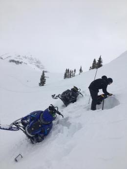
Dave and Ian are in Cooke City where they hunted for a thin layer of weak snow (near-surface facets) buried 1-2 feet deep. We know the layer exists in all our ranges, we just don’t know which specific slopes. Our tactic is the same everywhere: dig and test. Yesterday, Ian and Dave dug 6 snowpits and found the layer in their last one (video). Since the layer is close to the surface it is quick and easy to do stability tests (photo), the only way to detect it. It is not obvious until the test column snaps. You can’t see it. Dave and I hunted for it on Mt. Blackmore on Tuesday and did not find it in our 4 pits (video). When you do get it to break, it’s memorable because the layer propagates fast and clean. We have hard evidence of its existence on slopes in Hyalite, McAtee Basin and the Bridger and Centennial Ranges. Assume it is underfoot until you prove otherwise. Slopes with this layer can avalanche and should be avoided. The avalanche danger throughout these ranges is rated MODERATE.
If you get out, please send us your observations no matter how brief. You can submit them via our website, email (mtavalanche@gmail.com), phone (406-587-6984), or Instagram (#gnfacobs).
Upcoming Avalanche Education and Events
See our education calendar for an up-to-date list of all local classes. Here are a few select upcoming events and opportunities to check out:
March 29, 6 p.m., Free 1-Hour Avalanche Awareness, online Link to Join HERE
April 5, 6:30 p.m., Forecaster Chat with Alex Marienthal, hosted by Uphill Pursuits, “Spring Snowpack and Forecasting Tools”.
On Monday, March 22, a skier in Colorado was caught and killed by an avalanche in the backcountry near Beaver Creek Ski Area (preliminary information and photos). Saturday, a snowmobiler died when he stepped off his sled, broke a large cornice, and triggered an avalanche below (details and photos). We are sad to hear of these losses. Please continue to follow safe travel protocols, assess the snowpack, and come home at the end of a good day in the mountains.