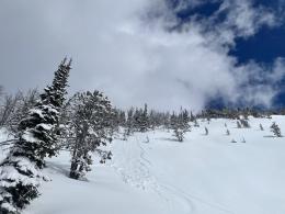
Good Morning. This is Dave Zinn with the Gallatin National Forest Avalanche Forecast on Tuesday, March 23rd at 7:15 a.m. Today’s forecast is sponsored by Grizzly Outfitters and Yellowstone Ski Tours. This forecast does not apply to operating ski areas.
Mountain temperatures are in the teens F with 5-15 mph winds from the northwest to north. There is 7-8” of new snow in the Bridger Range and around Big Sky with 3-4” in the other ranges. Today, high temperatures will be in the 20s F with 5-10 mph winds from the north. The mountains around Bozeman, Big Sky and Cooke City will get 2-4” of new snow with 1” near West Yellowstone.
All Regions
Since Friday, the mountains received 15-23” of new snow equal to 1.4-1.8” of snow water equivalent (SWE). Winds have been strong enough to transport snow at higher elevations and near ridgelines but overall have remained light to moderate through the storm. Avalanches today are all about the interface between the old and new snow. The snow fell onto an ice crust or a wet snow surface on many slopes and is bonding well. However, on some slopes that stayed cool during the March warm-up, new snow fell onto a thin, weak layer of near-surface facets. On Sunday, separate groups of skiers unintentionally triggered two avalanches in Hyalite Canyon. One was a close call that carried a skier several hundred feet down the mountain (Alex Lowe Peak details and photos, Mount Blackmore details). In Beehive Basin, a group triggered several loose snow avalanches or sluffs that would be hazardous in technical terrain (details and photo). On Saturday, skiers triggered a thin avalanche near Hyalite Peak that broke 150’ away from them and 150’ wide (photo and info).
Stack the deck in your favor by following safe travel protocols and assessing this interface with quick snowpits, each taking less than 2-minutes, as I demonstrate in my 59-second video. Expect changes at different elevations and aspects, so dig more shallow pits rather than one deep one. Watch our recent field videos from McAtee Basin, the Bridger and Centennial Ranges, and Cooke City for examples of where we found this layer.
Avalanches failing deeper than the interface are unlikely; however, the snow is stacking up. If you trigger a slide at the interface, now pushing 2’ deep, it is possible for it to step-down into older weak layers.
Today, human-triggered avalanches are possible, and the danger is rated MODERATE.
If you get out, please send us your observations no matter how brief. You can submit them via our website, email (mtavalanche@gmail.com), phone (406-587-6984), or Instagram (#gnfacobs).
Upcoming Avalanche Education and Events
See our education calendar for an up-to-date list of all local classes. Here are a few select upcoming events and opportunities to check out:
March 24, 6 p.m., Free 1-Hour Avalanche Awareness, online Link to Join HERE
March 29, 6 p.m., Free 1-Hour Avalanche Awareness, online Link to Join HERE
April 5, 6:30 p.m. Forecaster Chat, online hosted by Uphill Pursuits, “Spring Snowpack and forecasting tools”.
Yesterday, a skier was caught and killed by an avalanche in the backcountry near Beaver Creek Ski Area (preliminary information and photos). Saturday, a snowmobiler died when he stepped off his sled, broke a large cornice, and triggered an avalanche below (details and photos). We are sad to hear of these losses. Please continue to follow safe travel protocols, assess the snowpack, and come home at the end of a good day in the mountains.


