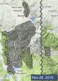
Advisory Archive
There is no new snow this morning. Temperatures are high teens to mid-20s F and winds are 5-15 mph out of the south and west. Today, temperatures will reach high 20s to mid 30s F. Winds will be 5-15 mph out of the southwest. A trace of snow is possible tonight. More substantial snowfall will begin tomorrow afternoon, favoring the southern ranges.


This morning the mountains have no new snow, temperatures are mid-teens to mid-20s F, and wind is 5-15 mph out of the west. Today, temperatures will reach high 20s to low 30s F and wind will be 0-10 mph. The next chance for snow is Sunday morning.


This morning, under partly cloudy skies mountain temperatures are in the high teens to low 20s F and winds are blowing west-southwest at 10-20 mph with gusts of 40 mph in the Bridger Range. There’s no new snow to report, nor is there any forecasted in the immediate future. Today will be mostly sunny with mountain temperatures reaching the low 30s and southwest wind blowing 15-25 mph.

In the last 24 hours the mountains around the Taylor Fork, West Yellowstone, and Cooke City received 1-2” of snow with the rest of the advisory area remained dry. Mountain winds were 15-30 mph from the west and temperatures hovered around 20 F. Today, winds will be 20-30 mph from the southwest, temperatures will be in the 30s, and Cooke City could get a trace of snow.


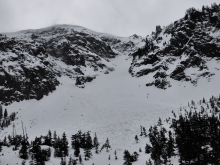
Last night the northern ranges received another 1-2” of snow and the southern ranges got 2-4”. Winds were 15-25 mph from the west to southwest with temperatures in the upper teens and 20s F. Today, the mountains around West Yellowstone and Cooke City will receive 2-4” and the northern ranges will get a trace to 1” before the snow tapers off this afternoon. Temperatures will be in the 20s F with winds from the west to southwest at 15-30 mph.


Early yesterday morning the mountains got 1-2” of new snow as the storm ended. Yesterday afternoon winds increased to 10-20 mph with gusts to 30 mph. This morning temperatures are single digits to teens F. Today, temperatures will reach mid-20s F and wind will be westerly at 20-30 mph. Tonight there is a chance for snow in the southern ranges and mountains near West Yellowstone with 2-3” possible by morning.


Since yesterday morning the mountains near West Yellowstone received 7” of snow, and elsewhere received 3-5” of low density snow. Yesterday wind was south-southeast at 10-20 mph with gusts to 40 mph. This morning wind shifted to the northeast-east at 5-15 mph, and temperatures are single digits F. Today temperatures will reach low teens F with north-northwest wind at 5-10 mph. Snow will stop later this morning and skies will clear by tomorrow.


Yesterday it snowed 1-2” in the Bridger Range to Big Sky, while the southern ranges to West Yellowstone and Cooke City got 3-5”. Winds have been moderate at 10-20 mph out of the E-SE and N-NW in the Bridger Range with temperatures in the low teens. This morning another snowstorm will impact our area. Winds will shift to the NW at 10-20 mph and by dawn tomorrow we will see 6-10” of new snow in the northern ranges and 8-12” in the southern mountains. The storm is expected to end late Saturday morning.
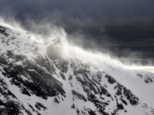
On Monday night the Bridger Range got 3” of new snow and on Tuesday evening 2” fell in Carrot Basin. Last night it snowed again and at 6 a.m. there is 1-2” of new snow in most areas with an additional 5” in Carrot Basin. Today will be snowy with 2-4” falling by tonight. A stronger system will begin early tomorrow through Saturday morning and drop another 2-4” in the northern ranges and 12” around West Yellowstone and Cooke City. Mountain temperatures will remain in the teens. Ridgetop winds, which are currently E-SE at 10-20 mph and gusting to 35 mph, will remain light to moderate and shift to the south.
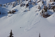
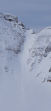
We will update our Weather Log and Regional Conditions every morning with snowfall totals, and our Avalanche Activity list if we get a report.


Last night the mountains near Big Sky got 2” of snow, near Cooke City got a trace, and elsewhere received no snow over the weekend. The last couple days wind was 20-40 mph with gusts of 50-60 mph, and temperatures reached high 30s F. This morning temperatures are teens F, and wind is 10-20 mph out of the west-northwest. Today will be the warmest of the week with temperatures in the 20s F, then temperatures will be mid-teens and single digits F through Thanksgiving. Today there is a chance for 1-2” of snow. More snow is expected Wednesday night through Thursday with 3-5” possible near Bozeman, Big Sky and Cooke City, and up to a foot near West Yellowstone.
We will update our Weather Log and Regional Conditions every morning with snowfall totals, and our Avalanche Activity list if we get a report.