Advisory Archive

Since Thursday evening, 7-9” of snow fell around Cooke City and West Yellowstone. The mountains near Big Sky and Bozeman received 13-19”. Ridgetop winds averaged 15-25 mph out of the west. Mountain temperatures generally remained below freezing with lower elevation temps reaching the low 30’s. Intermittent snowfall will continue through Wednesday, with another 6” to a foot of snow possible, favoring the northern mountains. Sunny skies and warmer temperatures return towards the end of the week.
We will update our Weather Log and Regional Conditions every morning with snowfall totals, and our Avalanche Activity list if we get a report.

A cold front will hit southwest Montana later this afternoon bringing snow tonight and again Saturday afternoon into Sunday morning. The storm will favor the mountains south of Bozeman including Cooke City. By morning 2-4” will accumulate with another 6-8” expected over the weekend. Mountain temperatures are forecasted to drop to the high teens with freezing line near 5,000’. Ridgetop winds will be westerly at 20-30 mph.
We will update our Weather Log and Regional Conditions every morning with snowfall totals, and our Avalanche Activity list if we get a report. Also, on the Regional pages are webcams and links to weather stations.


Winter arrived Tuesday night and over the last two days snow totaled 11-16” in the Bridger Range, 10-12” near West Yellowstone, and 4” near Big Sky, Hyalite and Cooke City. This morning temperatures are single digits above and below zero F. During the storm wind was 5-20 mph with gusts to 30 mph out of the northeast, and this morning wind is northerly at 5-15 mph. Today, temperatures will reach teens F under clearing skies with wind out of the north to northeast at 5-10 mph. On Friday and Saturday, winds will shift westerly and increase to 15-25 mph with temperatures in the 20s F Friday and 30s F through the weekend. The next chance for snow is late Sunday night.
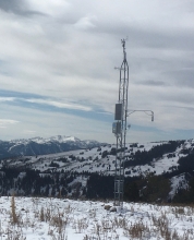
We will update 24-hour snow totals on our regional pages and weather log each morning. Also check our weather stations in Cooke City and Hyalite for hourly temperature and wind data, and find snowfall data via SNOTEL sites throughout our advisory area.
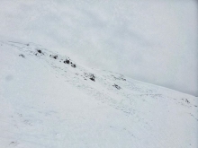
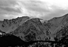
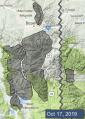
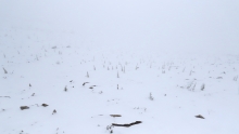
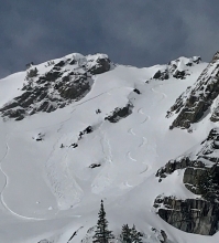
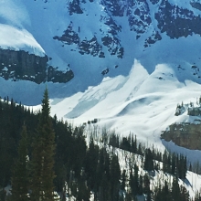
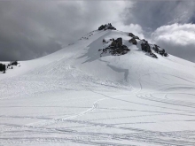
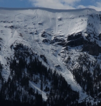
Cold and snowy weather the past week gave the mountains a fresh white coat, but total snow amounts were nowhere near the multiple feet our northern neighbors received (photo). Our advisory area got up to 16” near Cooke City with 6-8” elsewhere (weather log). Temperatures have been high teens to low 30s F. Wind was calm to moderate (5-25 mph) most of the week, and increased this morning with gusts to 30 mph.
Today temperatures will reach low 40s F under mostly sunny skies. Tomorrow afternoon a cold front will bring snow tomorrow night through Saturday morning. The mountains could get 6-12” of snow near Big Sky and Bozeman with 3-6” elsewhere. Wind on Friday and Saturday will be 20-35 mph out of the west-northwest. Temperatures will be 20s-30s F through the weekend, and will reach mid-40s F to start next week under clear skies. The next chance for snow is Tuesday night and Wednesday.
We will update 24 hour snow totals on our regional pages and weather log each morning. Also check our weather stations in Cooke City and Hyalite for hourly temperature and wind data, and find snowfall data via SNOTEL sites throughout our advisory area.

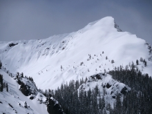
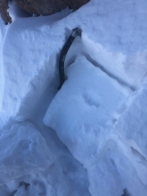
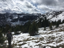
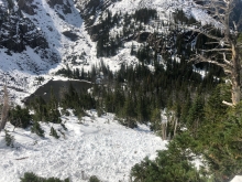
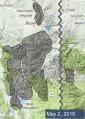
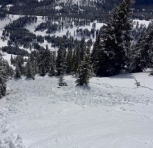
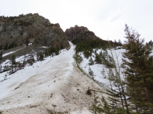
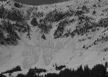
The mountains have a patchy distribution of 4-10” of snow above 8,000’ (photo and weather log). More snow and freezing temperatures are forecast for this weekend and early next week. Temperatures will be in the 40s F on Friday and cool through the weekend to highs in the 20s-30s F and lows in the teens-20s F. By Monday the mountains near Bozeman, Big Sky and Cooke City will have 6-16” of new snow.
Check our weather stations in Cooke City and Hyalite for hourly temperature and wind data, and you can find snowfall data via SNOTEL sites throughout our advisory area.
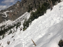
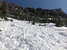
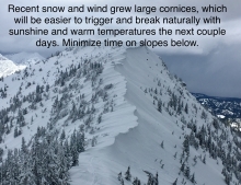
Spring weather can be highly variable and create a mix of avalanche problems to watch out for. Snow conditions and stability can change drastically from day to day or hour to hour. Anticipate rapid change and plan accordingly. Abundant snowfall over the winter with more spring snow to come makes avalanches possible into summer.


Since Friday the mountains got 10-15” of snow (0.8-1.5” SWE). Yesterday wind was gusty out of the northwest to north at 10-20 mph with gusts of 30-40 mph. This morning temperatures are single digits to low teens F and wind is northeast at 5-15 mph. Today through Wednesday temperatures will reach mid-20s F during the day with low temperatures overnight in the teens F, and wind will be easterly increasing to 20-30 mph tonight. Skies will be mostly clear with increasing clouds this afternoon and 1-2” of snow possible tonight and 3-5” possible Tuesday. The second half of the week will be warmer, drier and mostly sunny. High temperatures will reach 40s F by Thursday with overnight low temperatures in the high 20s to low 30s F next weekend.

Temperatures the past two nights were below or near freezing, 20s to mid-30s F, under mostly clear skies. Since Monday the mountains got a few scattered showers and a couple inches of snow. This morning wind is west-southwest at 10-20 mph, and this weekend wind will be westerly at 15-25 mph. Today temperatures will reach 40s F, and tonight cool to 20s F.
Through the weekend temperatures will cool with daytime highs in the 20s to 30s F and overnight lows in the teens F by Sunday. A front this morning will bring heavy precipitation to start a period of cool and wet weather. Scattered showers are expected through the weekend with rain late Saturday turning to snow at lower elevations on Sunday. By tomorrow morning 3-5” of new snow is possible above 8,000’, and by Monday an additional 5-10” is possible.

On Saturday rain fell up to 10,000’ with more than 1” of water in the Bridger Range and up to 0.5” near Big Sky and Cooke City. Sunday morning temperatures dropped to low 30s F and the mountains received 3-5” of snow. This morning temperatures are high 20s F and wind has been easterly at 5-15 mph. Today temperatures will reach 40s F under clearing skies, and wind will shift westerly at 5-10 mph.
Through the next week daytime high temperatures will be near 50 F with overnight lows near 30 F, and wind will be westerly at 10-20 mph with gusts to 30 mph. Expect mostly clear, dry weather with increased cloud cover Wednesday through the second half of the week. Cooler, wet weather is expected next weekend.

The mountains received 4-6” of snow Monday through Wednesday with westerly wind at 20-40 mph Wednesday evening. Yesterday temperatures reached high 40s to 50s F under clear skies. This morning under partly cloudy skies temperatures are mid-30s to mid-40s F, and wind is west-northwest at 15-25 mph.
Today will be mostly sunny with temperatures in the high 40s to 50s F and westerly wind at 15-25 mph. Clouds will increase overnight with temperatures in the 30s F, and there is a chance for precipitation Saturday afternoon. Early Sunday scattered rain showers will turn to snow with temperatures in the high 20s to low 30s F, and wind will shift easterly at 20-30 mph. By Monday 3-6” of new snow is possible in the mountains.