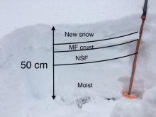
Advisory Archive

A quick storm Tuesday evening added 4-6” of snow to the mountains around Big Sky and Bozeman while the southern ranges remained dry. Winds were 10-15 mph from the southwest to northwest with temperatures falling from 40 F to the upper single digits to teens last night.
The week will end with clear skies, light northeast to southeast winds, and mountain temperatures reaching 25 F to 35 F. Friday night, winds will increase from the southwest 20 mph with partly cloudy skies Saturday and a chance for snow Sunday into next week.
We will update our Weather Log and Regional Conditions every morning with snowfall totals, and our Avalanche Activity list if we get a report.

A small storm Friday night dropped 3-4” of snow in the northern ranges and 1” in the south. Last night it rained to 9,000’ in the north and snowed 1-3” in the south. This morning mountain temperatures are in the mid-20s to mid-30s with W-SW wind blowing 15-30 mph. Today will be mostly cloudy with another storm tomorrow morning into Wednesday. The storm will start as rain and turn to snow later Tuesday. By Wednesday afternoon the mountains will have 3-5” of new snow. Thursday through the weekend is forecast to be dry and mild.
We will update our Weather Log and Regional Conditions every morning with snowfall totals, and our Avalanche Activity list if we get a report.
Tuesday night, the mountains received 2” of snow with 5” in Hyalite. There has been no precipitation since then, mountain temperatures have been in the 20s and 30s F with winds 15-30 mph from the west.
Warm, dry weather will continue until Friday night, temperatures will be in the 30s and 40s F with winds 10-20 mph from the west to southwest. Friday night, the mountains will get a trace to 2” of snow with lingering flurries around Cooke City. Our next chance for snow will come early next week.
We will update our Weather Log and Regional Conditions every morning with snowfall totals, and our Avalanche Activity list if we get a report.


On Sunday, temperatures dropped from the 40s F to the teens and single digits F. Precipitation started with rain up to ~8,000 ft but quickly switched over to snow at all elevations. 1-4” of snow fell by yesterday morning. This morning, temperatures are in the 20s F under partly cloudy skies. Winds are west and southwest at 5-20 mph with gusts up to 35 mph. Mountain temperatures today will rise into the mid-30s F with increasing cloud cover and slightly increasing southwest winds. A quick pulse of snow tonight will bring a trace to 2 inches of fresh snow. After skies clear tomorrow morning, expect blue skies and warmer temperatures through the end of the week.
We will update our Weather Log and Regional Conditions every morning with snowfall totals, and our Avalanche Activity list if we get a report.

The last week began with snow and mountain temperatures in the 20s F, but the dominant weather for the week was temperatures in the 30s and 40s F with clear skies. This trend will continue through Saturday before a cold front returns us to winter.
On Sunday, the mountains around Bozeman and Cooke City will receive 1-3” of snow, and Big Sky and West Yellowstone will get a trace of snow. Saturday night temperatures will fall into the 20s F, and winds will be from the west to southwest at 10-20 mph.
We will update our Weather Log and Regional Conditions every morning with snowfall totals, and our Avalanche Activity list if we get a report.


Over the weekend the mountains did not get any snow except for 1” in Hyalite on Saturday night. Temperatures were 20s to mid-30s F with westerly wind at 15-25 mph. Last night the mountains near Cooke City and Hyalite got 2-3” of snow with no snow elsewhere. This morning temperatures are 20s to low 30s F, and wind is westerly at 10-15 mph with gusts of 25-40 mph.
Today will be mostly cloudy with a chance for 1-3” of snow near Bozeman, Big Sky and Cooke City, and partly sunny with no snow near West Yellowstone. Through the week, temperatures will be mid-20s to mid-30s F under partly sunny to mostly cloudy skies with wind at 20-30 mph out of the west-northwest. The next chance for snow is next weekend.
We will update our Weather Log and Regional Conditions every morning with snowfall totals, and our Avalanche Activity list if we get a report.


The last week of October decided to dress up as January for Halloween. By Tuesday morning, the Bridger Range received 14” of snow with 2-4” elsewhere. Skies cleared during the week, winds were 15-30 mph from the northeast to west, and temperatures hit negative 20 F at the Flanders Mountain weather station on Tuesday. Last night, the mountains received 1-5” of snow, winds were 10-20 mph from the west to northwest, and temperatures were in the teens.
Lingering flurries will end this morning, and the skies will clear. Mountain winds will increase to 15-30 mph Saturday, with temperatures in the 20s, and our next chance for measurable precipitation will come Sunday afternoon. The mountains around Bozeman and Big Sky will get 2-4,” and Cooke City will receive 5-8” by Monday morning.
We will update our Weather Log and Regional Conditions every morning with snowfall totals, and our Avalanche Activity list if we get a report.

Since Friday evening 5-8” of new snow accumulated near Bozeman and Cooke City with 3” near Big Sky and West Yellowstone. This morning, mountain temperatures are 0-10 F and winds are 10-20 mph out of the west to northwest. Temperatures will peak in the single digits this morning before falling to -10 F tomorrow. Winds will increase to 15-25 mph from the north and northeast this afternoon. Snow will favor the Bridger and Gallatin Ranges with 6-8” by morning. The rest of our area will receive 4-6.” The remainder of the week will be dry with below-average temperatures.
We will update our Weather Log and Regional Conditions every morning with snowfall totals, and our Avalanche Activity list if we get a report.


Since Friday evening 5-8” of new snow has accumulated near Bozeman and Cooke City with around 3” near Big Sky and West Yellowstone. This morning, temperatures are in the single digits above and below 0 F. Winds are light out of the north and northwest. Today, temperatures will only rise into the teens F. Winds will increase slightly and shift more westerly. Expect increasing clouds today, with snowfall beginning tomorrow. 2-5” will accumulate by Tuesday morning. The rest of the week will be dry.
We will update our Weather Log and Regional Conditions every morning with snowfall totals, and our Avalanche Activity list if we get a report.

Since Monday the mountains received 7-11” of snow with some rain mixed in Tuesday evening. This morning temperatures are high 20s to mid-30s F and wind is 15-25 mph out of the west. Today, temperatures will reach mid-40s F and northwest wind will increase to 25-35 mph with gusts of 40-50 mph. Temperatures will cool to the 20s F Saturday morning, then drop to single digits to teens F on Sunday. Wind this weekend will be 15-25 mph and shift from northwest on Saturday to northeast on Sunday. Snow is likely Saturday morning with 6-12” possible throughout the advisory area by Sunday morning, except near West Yellowstone where 2-4” is expected.
We will update our Weather Log and Regional Conditions every morning with snowfall totals, and our Avalanche Activity list if we get a report.