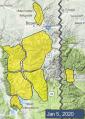
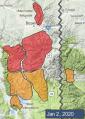
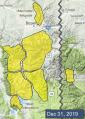
Advisory Archive
Yesterday afternoon a quick storm dropped 1-2” of snow near Bozeman, Big Sky and Cooke City. West-southwest wind was strong at 20-35 mph with gusts to 40-60 mph for most of yesterday. This morning west wind is 15-30 mph and temperatures are single digits to low teens F. Today, temperatures will be teens to low 20s F and wind will remain westerly at 15-30 mph. This afternoon light snow showers will begin with 2-4” possible near Cooke City and West Yellowstone, and 1-2” elsewhere by morning. More snow is expected tomorrow with highest amounts near Cooke City.


Three inches of new snow fell yesterday morning in Cooke City. Less than an inch fell elsewhere across the advisory area. Winds are 20-30 mph out of the south and west, with gusts into the 40s and 50s mph near Bozeman and Big Sky. Winds are lighter near Cooke City and West Yellowstone, at 10-20 mph. Temperatures vary widely this morning, from the high teens to low 30s F. Temps will rise into the high 20s and mid-30s F today. Winds will be 20-30 mph out of the southwest, with gusts up to 40 mph. Snowfall this afternoon will bring 1-3 inches by tomorrow morning.


A trace to an inch of new snow fell since yesterday morning. West and southwest winds are 20-30 mph with gusts up to 40 mph near Bozeman and Big Sky. Near West Yellowstone and Cooke City, winds are 10 mph with gusts to 30 mph. Temperatures are in the teens to low 20s F this morning and will rise into the 20s and low 30s F today. Scattered showers will bring a dusting to two inches of new snow by tomorrow morning, with winds staying steady.

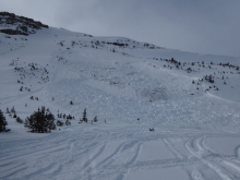
Snow yesterday followed by a strong pulse last night dropped 8” in the Bridger Range, 6” in Hyalite and 13” in Big Sky. In the southern ranges, Cooke City has 6”, Carrot Basin 5” and 2” at Lionhead. Ridgetop winds are from the west and averaging 20-30 mph with gusts of 45 mph and temperatures are in the teens. Scattered showers today and tonight will drop another couple of inches with decreasing wind.

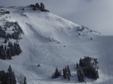

At 5 a.m. the mountains around Bozeman, Big Sky and Cooke City have 3-5” of new snow while the southern ranges to West Yellowstone have 6-8”. Winds are west to southwest at 20-35 mph with gusts of 60 mph in Hyalite. Temperatures are in the low 20s F in the north and 10 F in the south. Today, winds will lessen to 20 mph and temperatures will cool to the teens and single digits. By tonight an additional 4-6” will fall with 8” in Cooke City.


There was no new snow in our advisory area in the last 24 hours. This morning, mountain temperatures are in the single digits to teens F and winds are 10-20 mph out of the west to southwest. Winds are stronger in the Bridger Range and are currently blowing 20-35 mph from the west. The New Year will start right with snow beginning this afternoon and 6-10” falling by morning. Winds will blow 20-30 mph from the southwest and temperatures will rise into the 20s to low 30s.


Yesterday 1-2” of very low density snow fell near Bozeman and Big Sky, and elsewhere got no snow. This morning temperatures are single digits to low teens F. Wind is out of the northwest-northeast at 0-10 mph with gusts to 15 mph. In the Bridger Range wind is 5-15 mph with gusts to 25 mph at the ridgeline and downhill mid-mountain. Today will be partly sunny with temperatures in the teens to low 20s F and northerly wind at 5-15 mph. New snow is on tap for the New Year starting tomorrow night through Thursday morning.
Early yesterday morning the Bridger Range got 4” of near zero percent (0.5%) density snow. Elsewhere received no new snow. Yesterday wind was light out of the north-northwest. Overnight, wind shifted south-southwest at 5-10 mph with gusts over 20 mph. This morning temperatures are single digits below and above zero F. Today, under partly cloudy skies temperatures will be in the teens F and wind will be west-southwest at 5-15 mph. A few scattered snowflakes are possible, but no measurable snowfall is expected until early Wednesday.


This morning temperatures are in the single digits to low teens F and there is no new snow. Winds are 5-10 mph out of the north and west and will remain steady throughout the day. High temps will be in the teens F. Snow flurries today and tonight won’t bring significant accumulations.

A skiff of new snow fell yesterday morning in the Bridger’s, with no accumulations elsewhere. This morning, temperatures are in the single digits to teens F and winds are generally 10-20 mph from the southwest. High temps today will be in the teens to low 20s F. Winds will remain light out of the southwest. A dusting of snow will fall tonight, with more significant snowfall expected tomorrow night and into Sunday.