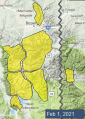
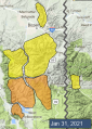
Advisory Archive
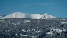
There are 16” of new snow in the Bridger Range, 4-7” in Hyalite, the Lionhead area, and near Big Sky, and 3” near Cooke City and in the Taylor Fork. Winds are west and northwest at 15-20 mph with gusts of 30-40. Temperatures are in the single digits and teens F. High temperatures will be in the teens and low 20s F. Winds will be 15-20 mph with gusts into the 30s out of the west and southwest.
Snowfall will continue today. By tomorrow morning, 3-5” will accumulate around West Yellowstone, with 5-10” around Big Sky, Bozeman, and Cooke City.


In the last 24 hours 4-6” fell in the Bridger Range and Hyalite and 3-5” fell around Big Sky, West Yellowstone and Cooke City. Wind is from the W-NW averaging 15-20 mph with gusts of 40 mph. Wind speed and direction won’t change today. Mountain temperature is 10F and will rise into the low 20s. It will snow again tonight with 4-6” expected by morning.
Ever the optimist, I think the Bridger Range could get more snow than 6” because they are in a snowfall wringing, moist, northwest flow. Just sayin’.

Snowfall started at midnight and by 5 a.m. the mountains around Bozeman to Big Sky and West Yellowstone have 4-6” with 3” in Cooke City. Temperatures are in the low 20s F and wind is W-SW averaging 15-20 mph with gusts of 40 mph. Today will remain snowy with SW wind averaging 10-20 mph and gusts into the 30s. Temperatures will remain in the 20s F. By morning I expect 4-6” in the northern ranges and Cooke City and 2-4” south of Big Sky to West Yellowstone.

This morning mountain temperatures are in the upper-20s to 30 F and the wind is blowing 15-20 mph from the southwest. Today, high temperatures will be in the upper-20s to 40 F with winds increasing from the southwest to 20-30 mph. Snow returns tonight and the mountains will receive 2-4” of new snow by morning.
Mountain temperatures this morning range from the mid-teens to mid-20s F with 15-20 mph winds blowing from the south to west. Today, temperatures will peak in the mid-30s to low 40s F with 10-15 mph winds from the south to southwest. Snow and colder temperatures will return mid-week.


As the storm ended yesterday morning the mountains got 3-4” of snow. This morning wind is west-southwest at 10-15 mph with gusts to 25 mph, and temperatures are single digits to teens F. Today temperatures will reach high 20s to low 30s F, and west-southwest wind will continue at 10-15 mph with gusts to 25 mph. The next few days will be mostly clear with snow returning late Tuesday or Wednesday.

Since yesterday morning the mountains from Big Sky to West Yellowstone got 6-9” of new snow, and elsewhere got 3-5” inches. During yesterday’s heavy snowfall in the southern ranges, wind was south-southwest at 15-20 mph with gusts of 30-50 mph. This morning wind is 5-15 mph out of the west-northwest and temperatures are teens to low 20s F. Today temperatures will reach mid-20s F with west-northwest wind at 10-25 mph. Snow will continue with another 1-3” before skies begin to clear this afternoon.


In the last 24 hours 7” of snow fell in Taylor Fork to West Yellowstone and 2” outside Cooke City. South to west wind is blustery with speeds averaging 10-20 mph and gusts into the 50s. Temperatures are in the mid 20sF under cloudy skies. Wind will continue unabated today and lessen overnight. By tomorrow morning the mountains towards West Yellowstone will get an additional 6-8” with the mountains around Big Sky, Bozeman and Cooke City getting 2-3”.
At 5 a.m. the southern mountains are getting snow with Taylor Fork showing 10”, West Yellowstone getting 8” and Cooke City with 2”. The storm will continue in the south and not reach the Big Sky and Bozeman areas today. Currently wind is south to southwest at 15-30 mph with gusts of 50 mph and temperatures are in the mid teens F. Wind and temperatures will not change much throughout the day. By tomorrow morning the mountains south of Big Sky to West Yellowstone will get an additional 8-12” with Cooke City getting 4”. The storm will continue into Friday and hit the northern mountains that evening.


Mountain temperatures are in the single digits to low teens F with 15-25 mph winds from the southwest and there is 1" of new snow in the mountains around West Yellowstone.
Today, temperatures will be in the upper teens to mid-20s F. West Yellowstone will receive 5-7" of new snow and Cooke City will receive an inch. The rest of the advisory area will get the associated 15-25 mph winds from the south to southwest. Snow will move north Friday night into Saturday.