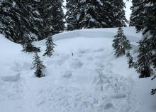
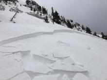
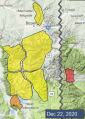
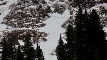
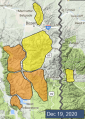
Advisory Archive
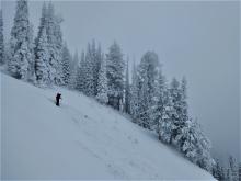
Since yesterday morning the mountains got 6-9” of snow near Bozeman and Big Sky with 3-5” near West Yellowstone and Cooke City. This morning temperatures are in the teens F and wind is west-northwest at 5-15 mph with gusts to 25 mph, and gusts to 40 mph in the Bridger Range. Today temperatures will be teens to low 20s F with west-northwest wind at 10-25 mph. Skies will clear later this morning with a couple days of cold, clear weather to start the week. The next chance for snow is late Wednesday.


This morning there is no new snow, temperatures are high 20s to low 30s F and wind is west-southwest at 15-25 mph with gusts of 40-50 mph. Today, temperatures will cool to the 20s F and wind will remain westerly at 15-30 mph with gusts over 40 mph. Snow is expected this morning in the southern mountains and will move north through the day. By tomorrow morning the mountains near Bozeman and Big Sky will have 3-5” of new snow with 5-8” possible near West Yellowstone and Cooke City.


It seems that southwest Montana must have been on Santa’s naughty list this year - which is to say, there is no new snow to report. Winds have been 10-20 mph with gusts of 20-40 mph out of the south and west. Temperatures this morning are teens to high 20s F. Winds will continue at 10-20 mph today out of the southwest under partly sunny skies. Temperatures will rise into the 20s and low 30s F. A few snow flurries tonight won’t leave much accumulation.
There is no new snow to report and none is expected until Saturday. Wind, on the other hand, is in ample supply. West winds are blowing strongest in the north at 20-40 mph and 5-15 mph in the southern ranges. These speeds will subside today. Under sunny skies, temperatures are in the single digits to teens and will warm into the low 20s. It’ll be a clear night of smooth sailing for Santa. I can’t wait to get my new lump of coal.


In the last 24 hours snowfall stopped, winds decreased and temperatures dropped. The mountains around Bozeman and Big Sky picked up 5-7”, Cooke City got 4” and the mountains south of Big Sky to West Yellowstone received 1-2”. West to north winds subsided from gusts of 50+ to 10-30 mph this morning. Mountain temperatures will only reach the teens to low 20s under clearing skies. No snow is expected until the weekend.

In the last 24 hours, Cooke City received 11" of new snow with 1-2" near West Yellowstone and none elsewhere. Winds are 15-30 MPH from the south to the west with gusts hitting 70 MPH and temperatures are near or above freezing. Temperatures will drop through the day, winds will shift from the southwest to northwest at 20-30 MPH, and new snow will begin falling later this morning. The mountains around Cooke City, West Yellowstone and Big Sky will get 6-8" by morning with 2-4" in the mountains around Bozeman.

New snowfall favored the southern ranges with 6" in Cooke City and 3" near West Yellowstone while the mountains around Bozeman and Big Sky remained dry. West winds blew 15-30 MPH gusting up to 75 MPH. Snow will continue today with 5-6" in the mountains around Cooke City, 1-2" in the Lionhead area and a trace in the mountains around Bozeman and Big Sky. Winds will blow 5-15 MPH from the southwest before ramping back up this evening and mountain temperatures will be in the 30s.


Since yesterday morning the mountains near Cooke City and West Yellowstone got 2-4” of snow while less than 1” fell elsewhere. This morning, temperatures are teens to 20s F in the southern ranges and 20s to low 30s F near Bozeman and Big Sky. Winds are west-southwest at 20-35 mph with gusts of 40-60 mph.
Strong westerly wind will continue today with gusts to 40-60 mph, and temperatures will reach high 20s to low 30s F. Snowfall will favor the southern mountains with 7-10” near Cooke City by tomorrow morning, 5-7” near West Yellowstone, 1-3” near Big Sky and less than 1” in the mountains near Bozeman.


While no new snow fell in the last 24 hours, winds have been strong and gusty. Wind speeds are consistently in the 20s mph with gusts into the 40s and 50s mph out of the southwest and west (hitting 60 mph on the summit of Lone Peak). These strong winds will continue today. Temperatures this morning range from the low teens F to high 20s. High temperatures today will be high teens and 20s F under cloudy skies. Snow flurries today won’t amount to much accumulation. Another round of snow starts tonight favoring the Cooke City area. Expect 2” in Cooke City by tomorrow morning with a trace to 1” elsewhere.


Since yesterday morning, 2” of snow fell in the mountains around Bozeman. 3-5” fell around West Yellowstone and Cooke City. The Yellowstone Club picked up 7” while Big Sky Resort only got around 3”. Temperatures this morning are in the teens F. Winds are 15-20 mph from the west-northwest with gusts of 30-40 mph. Today, winds will shift a more southwesterly and continue to blow 10-20 mph with higher gusts. High temperatures will be in the high teens and 20s F. Skies will be mostly cloudy today with a light dusting of snow expected tomorrow morning.