Advisory Archive
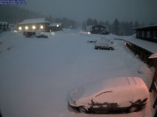
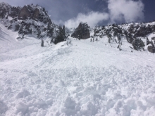
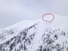
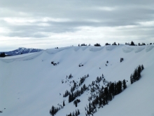
At 5 a.m. the Bridger Range has 12” of heavy new snow and the mountains near Big Sky have 8”. SNOTEL is not reporting data elsewhere, but webcams show new snow in Cooke City and West Yellowstone (photo). Temperatures are 20s F this morning and will reach mid-30s F today. Wind will be northeast at 15-25 mph. Snow showers are expected through this afternoon and the mountains could get 4-6” today.
Tuesday will be mostly clear with temperatures in the 40s F. There is a chance for light precipitation Wednesday evening, and the rest of the week will be mostly sunny with highs in the 40s F and overnight lows in the 20s F. Snow and rain appear in the forecast again next weekend.


It’s hard to imagine, but the next few days will be sunny and warm. Highs today and through the weekend will reach the mid to upper 40’s F in the mountains and 50’s to 60’s in the valley. Lows will be in the 20s’ F. Winds will remain light to moderate out of west-southwest. There is little to no chance of precipitation the next few days. The next chance for rain and snow will be Monday and Tuesday.
There is no new snow to report over the past 24 hours. This morning skies are mostly clear and temps range from the upper 20’s to mid-30’s F. Winds are blowing 15-30 mph out of the SW with gusts around Hyalite and Big Sky breaking 50 mph. Today, skies will become increasingly cloudy as a cold front approaches the region. Valley rain and mountain snow are likely this afternoon with the frontal passage. There’s also the possibility of a thunderstorm. The mountains south of Bozeman will see 2-4” by tomorrow morning while the Bridger Range will see 1-3”. Highs today will climb to the upper 30’s to low 40’s before the cold front reaches the area. Winds will remain moderate to strong out of the SW. Winds will shift to the W-NW behind the front. Cloudy skies and cooler temps will remain over the region through Wednesday.


In the last 24 hours the mountains around West Yellowstone picked up 2” of snow, with up to an inch falling in other areas. This morning is mostly cloudy with winds 10-25 mph out of the southwest, and a freezing line of 7,000’. Mountain temperatures will rise into the 40s F this afternoon. Scattered precipitation today will drop rain or snow (1-2”) depending on the elevation. Thunderstorms are likely. Tonight will be below freezing and winds will shift to the southeast.
Another 1-2” of snow fell yesterday. At 5 a.m. skies are partly cloudy, temperatures are in the high teens to low 20s F, and winds are westerly at 15-30 mph. The weekend will be mostly cloudy with daytime highs reaching the 40s today and near 50 F tomorrow. Scattered snow showers will drop another 2-4” by Monday morning as winds shift southwest at 20 mph.
Winter will keep us hostage through next week, maybe longer, as Spring negotiates our release. Below average temperatures and above average precipitation remains on track for the rest of April.
Winter is here. Still here. A major spring storm ends this morning, and over the last 24 hours it dumped 20-30" in the Bridger Range, 14-20” in Hyalite and Big Sky, and 6-9” near West Yellowstone and Cooke City. Wind overnight was west to northwest at 15-25 mph with gusts of 30-45 mph. This morning, temperatures range from low teens to mid-20s F, and will be 20s to low 30s F today. Snowfall tapers off this morning with another 2-3” possible.
This weekend will be mostly cloudy with a few periods of sunshine possible and temperatures in the 30s to low 40s F. Light snow showers Saturday and Sunday evenings could drop 2-4” with more expected late Monday to Tuesday.
Since yesterday morning the mountains got 3-5” of new snow. This morning, temperatures are teens to mid-20s F and wind is west to northwest at 15-25 mph. Temperatures will reach high 30s F today with west to northwest wind at 10-20 mph. Today and tomorrow will be partly cloudy with no precipitation expected, and temperatures tomorrow in the mid-40s F. Cloud cover will increase tomorrow afternoon with 2-3” of snow expected Wednesday morning and more snow likely Wednesday night through Thursday.


Winter maintains its edge over spring this morning with 3-4” of new snow throughout the advisory area. Temperatures this morning are teens to low 20s F and wind is westerly at 15-20 mph with gusts of 30-40 mph overnight. Today, temperatures will be high 20s to mid-30s F with west wind at 15-25 mph and mostly cloudy skies. Intermittent snow showers are likely through today and tonight and the mountains will get 3-6” of snow by morning. Clear spring weather is forecast late Monday and Tuesday followed by more active and wet weather later in the week.

The battle between spring and winter is fierce today, and the resulting weather outlook isn’t pretty. The mountains got 1-2” of new snow as the storm tapered yesterday morning. This morning, temperatures are 20s F and wind is westerly at 5-15 mph with gusts to 20 mph. Today, south-southwest wind will increase to 20-30 mph and temperatures will reach 30s to low 40s F. Light rain is expected this afternoon with a slight chance of thunder. Tonight, snow showers will total 1” near Bozeman and Big Sky with 3-5” possible near Cooke City and West Yellowstone.
Has anyone seen Spring? She’s late for her shift and I’m not happy about it, and neither is winter who is covering for her. In the last 24 hours our forecast area picked up 6-8” of snow. Winds are 10-25 mph out of the W-SW, except in the Bridger Range where a cold east wind is blowing. Temperatures are 2F on the Bridger Ridge and 20-30F most other places. Another inch of snow may fall this morning, then skies will be mostly cloudy and winds will shift E-SE at 10-20 mph in most areas.