Advisory Archive
Over the past 24 hours the Bridger Range picked up 8” of new snow. The Gallatin and Madison Ranges received 4-5” while the mountains around West Yellowstone and Cooke City squeezed out 1-2”. This morning temperatures are in the teens F under partly cloudy skies and winds are blowing 5-20 mph out of the SW. Today, skies will remain partly to mostly cloudy and no new snow is expected. Temps will warm into the 20’s to low 30’s and winds will remain light to moderate out of the SW. Snow moves back into the area tonight. The southern ranges could see 1-2” by tomorrow morning while the northern areas will remain dry. Snow intensifies tomorrow and the mountains could see 6-10” by Sunday.


Overnight the Gallatin and Madison Ranges picked up 4-6” of new snow. The mountains around West Yellowstone, Cooke City and the Bridger Range received 1-2”. At 5 a.m. temperatures range from the 20’s to low 30’s F and winds are blowing 10-20 mph out of the SW. Today, snow showers will gradually diminish and temps won’t warm much as cooler air moves into the region. Snow shuts off this evening and no snow is expected tonight and tomorrow.
At 5 a.m. under clear skies, temperatures are in the high 20s F with freezing line at 8-8500’. Winds are 10-20 mph and gusting to 45 mph out of the S-SW. Clouds are moving in this morning and temperatures will reach the 40s F with steady ridgetop winds. Later this afternoon a southwest flow will bring rain and snow and by morning I expect the mountains around Bozeman and Big Sky to have 1-2” of snow and 2-4” outside West Yellowstone and Cooke City. Colder temperatures and intermittent snow are forecasted through the weekend.

At 5 a.m. under clear skies, mountain temperatures are in the low 20s F and wind is southwest to southeast at 5-10 mph. Today will be sunny and mountain temperatures will reach the upper 40s F, our warmest of the season. Tonight will remain clear and temperatures will drop into the 20s F and tomorrow looks to be even warmer, but cloudy.
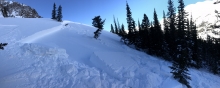
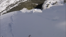
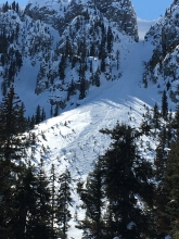
Wet Avalanche Danger
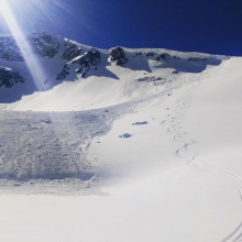
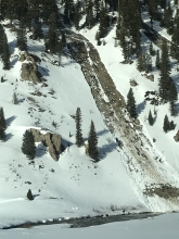
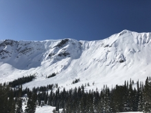
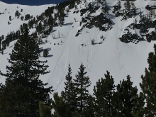
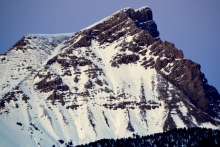
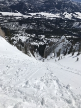
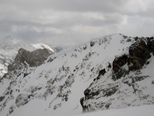
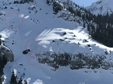
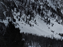
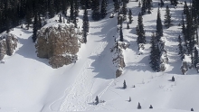
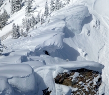
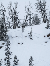
The threat of wet avalanches will increase this afternoon on steep and sunny slopes, especially those with rock outcroppings or cliffs. Yesterday, I rode into Carrot Basin and found an icy crust on slopes exposed to the sun (video). Once this crust melts wet snow avalanches will release naturally. Rollerballs (photo), pinwheels or wet loose avalanches are signs to avoid avalanche terrain. Today, the wet snow avalanche danger will rise to MODERATE once the surface crust melts (photo, photo).


This morning the mountains do not have any new snow, temperatures are high teens to 20s F and wind is south to westerly at 5-15 mph. Today will have clear skies with temperatures in the high 20s to high 30s F and light wind at 0-5 mph. The next chance for snow is late Wednesday.


The mountains did not get any new snow over the last 24 hours. This morning, temperatures are teens to low 20s F and wind is southerly at 10-15 mph. Today will be sunny with temperatures in the 20s to low 30s F, and wind will be south to southwest at 5-15 mph.
Since yesterday morning the mountains near Cooke City got 4-6” of snow. The mountains south of Bozeman, near Big Sky and West Yellowstone got 1”, and the Bridger Range got less than 1”. Temperatures this morning are single digits to teens F and will warm slowly to 20s and low 30s F this afternoon. Yesterday, wind was southwest at 25-40 mph with gusts of 40-60 mph. Today, wind will be northerly at 5-15 mph. This weekend will be mostly sunny and no snow is expected until later next week.
Over the past 24 hours the mountains around Big Sky, West Yellowstone and Cooke City picked up 2-4” of new snow. The mountains around Bozeman remained mostly dry. At 5 a.m. temps range from the teens to mid-20’s F and wind are blowing 15-30 mph out of the W-SW. Today, highs will warm into the upper 20’s to low 30’s F and winds will continue to blow 15-30 mph out of the W-SW. There will be a quick break in the weather this morning, but snow returns this afternoon and evening. By tomorrow morning the southern mountains will see 2-4” of new snow while the north will see 1-2”.
Overnight the mountains around Cooke City and West Yellowstone picked up a trace to 1” of snow. At 5 a.m. temps range from the teens to low 20’s F and winds are blowing 10-25 mph out of the W-SW. Today, skies will become increasingly cloudy as a weak storm approaches. Winds gradually increase by this afternoon and will blow 15-30 mph out of the W-SW. Temps will warm into the upper 20’s to low 30’s F. The mountains around Cooke City and West Yellowstone will see 2-3” of snow by tomorrow morning while the mountains around Bozeman and Big Sky will see 1-2”.
Under clear skies, mountain temperatures are in the single digits to low teens with winds 10-15 mph out of the W-SW. Today will be sunny and temperatures will warm into the mid-30s with light winds. No snow is expected until Friday. Today will be our first day of warm, spring-like weather this season.
A factoid from the Yellowstone Club: at the Timberline Wx station (9400’) the temperature has only been above freezing for 12 hours since skiing started in December. The last time above 32F was on January 16th.