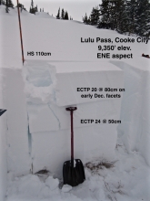
Advisory Archive
Yesterday morning a fast moving cold front was accompanied by southwest wind at 30-60 mph. The mountains from Bozeman to West Yellowstone got 2-3” of snow with 4” near Cooke City. This morning, wind decreased to 10-20 mph out of the west-northwest and temperatures are in the single digits to low teens F. Cloud cover will decrease through today with westerly wind at 15-25 mph and temperatures in the teens F. Light snow showers are expected tomorrow through Christmas.


Overnight a trace to one inch of snow fell in the mountains south of Bozeman including Cooke City. At 5 a.m. temps range from the teens to mid-20’s F and winds are blowing 30-60 mph out of the west-southwest with gusts near Big Sky breaking 70 mph. A fast moving front this morning will deliver 1-3” of snow. This storm will be short lived and snow tapers off by late morning. Highs today will warming into the mid to upper 20’s and winds will remain strong out of the west-southwest. No snow is expected tonight or tomorrow.

There’s no new snow to report this morning and temps are in the teens under mostly clear skies. Winds are blowing 10-30 mph out of the west-southwest. Today, temps will warm into the mid to upper 20’s and winds remain light to moderate out of the west-southwest. Skies will start out mostly clear, but become increasingly cloudy by this afternoon. A weak storm moves into the area later tonight. By tomorrow morning the mountains will see 1-3” of new snow.


At 5 a.m. snowfall is tapering. Mountain totals are 2-3” at SNOTEL sites in the Bridger and northern Gallatin Ranges and 5-6” elsewhere. Winds are blowing strong out of the west to northwest and will remain so today. Average speeds are 25-30 mph with gusts of 50-60 mph. Mountain temperatures are in the high teens to low 20s F this morning. Today will turn partly cloudy and remain cool, with the next possible snow falling Friday.
At 6 a.m. an inch of snow has fallen in the mountains outside West Yellowstone and Cooke City. Temperatures are in the low to high 20s and winds are southwest at 15-20 mph with gusts of 40 mph. Today, snowfall and wind will continue around West Yellowstone and Cooke City. By tomorrow morning these mountains will have 4-6” of snow with 1-2” elsewhere. Temperatures will remain in the 20s and wind will increase from the southwest.

This morning, temperatures are high 20s to low 30s F and wind is southwest at 20-35 mph with gusts of 40-50 mph. There is no new snow to report, but that pattern will change in the next couple days. Today, temperatures will be low 30s F and cool to mid-20s F this afternoon with southwest wind at 20-35 mph. The mountains near West Yellowstone could get 1-2” of snow tonight with a trace elsewhere, and more snow throughout the area tomorrow and Wednesday.

This morning the mountains have no new snow, temperatures are in the 20s F, and wind is out of the southwest at 15-25 mph with gusts to 40 mph. Today will be mostly sunny with temperatures in the low 30s F and wind out of the south-southwest at 15-25 mph. Cloud cover will increase this evening and there is a chance for snow tomorrow afternoon.


Overnight the mountains near Cooke City picked up 1-2” of new snow. No new accumulation is expected today. This morning, temps are in the 20’s F and winds are blowing 20-50 mph out of the west-southwest with gusts around Big Sky breaking 60 mph. Warm and windy conditions will continue through the day. Highs climb into the upper 20’s to low 30’s F and winds remain strong out of the west-southwest. No new snow is expected through the weekend.
Over the past 24 hours the mountains near West Yellowstone and Cooke City picked up 1-2” of new snow. This morning temps range from the 20’s F in the north to single digits F in the south. Winds are blowing 15-30 mph out of the west-southwest. Today, skies will be partly cloudy and temps will warm into the upper 20’s F in the north and teens in the south. Winds remain moderate to strong out of the west-southwest. There is an increasing chance for snow this evening around West Yellowstone and Cooke City. These areas will likely see 1-2” by tomorrow morning.

Yesterday morning a quick pulse of snow dropped 3-4” in the mountains around Bozeman and Big Sky including the southern Madison Range. The mountains around Cooke City and West Yellowstone picked up 1-2”. Snow shut off by noon yesterday and no new snow accumulated overnight. This morning, temps range from the single digits to low teens F under mostly clear skies. Winds are blowing 15-40 mph out of the west-southwest. Today, warm and windy conditions will continue. Highs will climb into the upper 20’s F and winds will remain moderate to strong out of the west-southwest. No new snow expected tonight or tomorrow.
