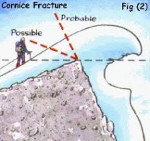
Advisory Archive
Overnight the Big Sky area picked up 3” of new snow with 1-2” falling everywhere else. Winds are averaging 15-20 mph out of the west with gusts of 30 mph. Mountain temperatures are in the single digits. Today will become partly cloudy as high pressure builds across Montana. Temperatures will reach the 20s and winds will be light from the west-southwest. No new snow is expected in the next couple days.

Since yesterday morning the mountains near West Yellowstone and Cooke City got 2-4” of new snow. Elsewhere got 4-6” with 14” of low density snow at Big Sky and 11” in the Bridger Range. Temperatures this morning are single digits to low teens F and will be in the teens today. Overnight, wind was northwest-west at 15-25 mph with gusts of 30-40 mph. Moderate west-northwest wind will continue today. Light snow showers in the mountains through tonight will total 3-5” of low density snow by morning.


At 5 a.m. it is snowing lightly in Bozeman with no new snow in the Bridger Range and 1” near Big Sky and Hyalite. The mountains near West Yellowstone and Cooke City got 4-6” of new snow since yesterday morning. Temperatures this morning are low teens F and will remain in the teens F today. Wind is east-northeast at 5-15 mph and will shift northwest at 15-25 mph early this afternoon. The mountains will get 4-6” of snow by morning with a deeper dump of cold smoke powder possible near Bozeman and Cooke City.

Since yesterday morning the mountains near West Yellowstone picked up 6-8” of new snow while the mountains around Cooke City picked up 2-3”. The mountains around Big Sky squeezed out a trace to 1” while the mountains around Bozeman remained dry. This morning snow has exited the area and temps range from the single digits to low teens F under partly cloudy skies. Winds are blowing 10-25 mph out of the S-SE. Today, temps will warm into the upper teens to mid-20’s and winds will remain light to moderate out of the S-SE. There will be a brief break in the weather today, but another round of snow is forecasted to impact the area tonight and tomorrow. Most areas will see 1-3” by tomorrow morning with the exception of Cooke City which will see 3-5”. Snow continues through the day tomorrow.
Overnight the mountains near West Yellowstone picked up 2-3” of new snow while the Cooke City area picked up 1-2”. The rest of the advisory area remained dry. At 5 a.m. temps are in the teens to low 20’s F and winds are blowing 15-30 mph out of the S-SE with gusts in Hyalite breaking 50 mph. Today, 4-6” of new snow will fall in the mountains near West Yellowstone and 2-3” will accumulate around Cooke City. The mountains around Bozeman and Big Sky will see 1-3”. Snow diminishes this evening, but the southern mountains could see an additional 1-2” overnight. Highs today will warm into the 20’s F and winds will continue to blow 15-30 mph out of the S-SE with stronger gusts possible along the ridgelines.

At 5 a.m. there’s no new snow to report and temps range from the single digits to low teens F. Winds are blowing 15-30 mph out of the W-SW. Today, highs will warm into the teens to mid-20’s F and winds will remain moderate to strong out of the W-SW. Skies will become increasingly cloudy as the next storm system approaches. There is a slight chance for mountain snow showers this afternoon with a better chance this evening. By tomorrow morning the southern mountains will see 2-4” of new snow while the northern ranges will see 1-3”.
At 5 a.m. under partly cloudy skies, temperatures are in the single digits and winds are W-SW averaging 10-15 mph with gusts of 30 mph. Today will be partly cloudy, temperatures will rise into the high teens and winds will remain the same. There is no snow expected until Thursday evening.


Call in sick today, because in the last 24 hours it dumped 22” of fluffy powder at Bridger Bowl (15” yesterday + 7” last night), near 10” at Big Sky, 6-8” around Cooke City and West Yellowstone, and at least 2” everywhere in between. At 5 a.m. it is still snowing in the northern ranges which should end soon, but then again it wasn’t supposed to snow that much to begin with, so all bets are off. Winds were remarkably calm yesterday, but not anymore: they are averaging 20-25 mph with gusts of 35-50 mph out of the W-SW. Temperatures will rise from the single digits to teens today with clouds increasing and winds turning west and remaining strong.


This morning there is no new snow in the Bridger Range and 1” in Hyalite and Big Sky. The mountains near West Yellowstone and Cooke City got 3-7” of new snow as of 9 o’ clock last night. SNOTEL stations are not showing data after that and higher snow amounts are likely. Temperatures this morning are single digits to teens F and will be in the teens F today. Wind overnight was southwest at 20-30 mph with gusts to 50 mph. Wind will remain strong in the southern ranges this morning, and elsewhere will shift northerly at 5-15 mph. Snow showers today will drop 2-4” near Bozeman and Big Sky and 5-7” near West Yellowstone and Cooke City.

Since yesterday the Bridger Range got 8” of low density snow, Hyalite got 1”, and elsewhere 3-4”. This morning, wind is westerly at 25-30 mph with gusts of 40-50 mph and temperatures are single digits F. Today, strong west wind will continue with temperatures in the teens F. Snow will return this afternoon with 5-8” in the mountains overnight and more through tomorrow morning.
