Advisory Archive
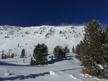
Last night Lionhead received 4” of snow, the southern Madison Range got 1” and Cooke City received 2". Around Bozeman and Big Sky winds are blowing west-southwest at 25-30 mph with gusts of 60 mph. Temperatures are in the 20s F. Near West Yellowstone and Cooke City winds are west at 10-15 mph with gusts of 30 mph and temperatures near 10 F. This morning 1-2” will fall and winds will continue to be strong into the evening. Skies will clear this afternoon and temperatures will drop into the teens tonight.


An evenly distributed 3-4” of new snow fell overnight. At 6 a.m. wind is from the west at 10-15 mph with 30 mph gusts in Hyalite. Mountain temperatures are in the teens F. Today will become mostly cloudy and west winds will increase to 30 mph. Snow will fall tonight and I expect 2-4” by morning with more accumulation on Wednesday.


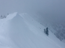
This morning the mountains have no new snow. Temperatures are mid-20s to 30 F at ridgetops and low teens F at lower elevations. Wind overnight was west to southwest at 10-20 mph with gusts of 30-35 mph. Today, wind will be southwest at 10-15 mph with gusts of 20-30 mph and temperatures will be mid-20s to low 30s F. Increasing cloud cover through the day will be followed by snow showers overnight with 2-4” possible by morning. More snow is expected Tuesday night and Wednesday.
This morning temperatures are in the teens F, the mountains have no new snow, and wind is westerly at 10-20 mph. Today will be mostly sunny with temperatures in the high 20s to low 30s F and wind out of the west to southwest at 10-20 mph. The next chance for snow is Tuesday morning.


This morning the mountains have no new snow, temperatures are teens to low 20s F, and wind is 10-20 mph with gusts of 25 mph out of the west-southwest. Today, temperatures will be in the mid-20s F with westerly wind at 15-25 mph. The high pressure weather pattern will continue through the weekend with the next chance for snow Tuesday morning.
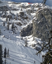
A strong inversion this morning is making mountain temps warmer than the valleys. At 5 a.m. temps in the mountains around Bozeman and Big Sky are in the teens to low 20s F. Conditions are cooler around West Yellowstone and Cooke City where mountain temps are in the single digits F. Winds are blowing 5-20 mph out of the west-southwest. Today, nice weather continues as a ridge of high pressure remains parked over the area. Temps warm into the mid to upper 20s F and winds remain light to moderate out of the west-southwest. Nice weather continues through the weekend.
This morning temps range from the single digits above or below zero F under clear skies. Winds are blowing 10-20 mph out of the west-southwest. Skies will remain clear today and temps will warm into the teens F. Winds will blow 10-20 out of the west, but shift to the northwest this afternoon. No new snow is expected through the weekend.

There’s no new snow to report, just clear skies and pre-dawn temperatures from zero to 10F. Winds are blowing westerly at 20-30 mph around Bozeman and Big Sky and 10-15 mph near West Yellowstone and Cooke City. Today will be sunny and mountain temperatures will rise into the high teens before plummeting to near -10F tonight. Brrr. Better plug in the car.

Yesterday, the mountains from Big Sky to West Yellowstone and Cooke City received 2-3” of new snow and light westerly wind. This morning skies are clear, temperatures are in the single digits to low teens and winds are blowing from the west at 15-30 mph. Today temperatures will rise into the 20s and drop to near zero tonight with moderate westerly wind. High pressure will block further snowfall through the weekend and bring cold, dry and sunny days.


This morning the mountains do not have any new snow and temperatures are single digits F. Wind was 0-5 mph out of the southeast-east yesterday and will be west-southwest at 0-10 mph today. Temperatures will be teens F today, and a trace to 1” of snow is possible near West Yellowstone and Cooke City. The rest of the week is forecast to be cold and dry.