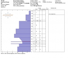
Advisory Archive
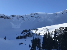
This morning at 5 a.m., skies are cloudy, wind is blowing and mountain temperatures are near 20F. Most ridgelines have S-SW winds averaging 15-25 mph with gusts of 50-60 mph in Hyalite and Cooke City. Light snowfall today and tonight will drop 1-2” in the northern ranges and 2-4” in the south. Winds will remain gusty and strong from the southwest today, but lessen and switch west tonight.


Yesterday, 1-2 inches of snow fell in the southern mountains. Under partly cloudy skies temperatures are near 20F in the north and 10F in the southern areas. Strong wind from the southwest is blowing at the ridgetops and mid-elevations. Speeds are averaging 25-35 mph with gusts of 50 mph in Hyalite. Today will be partly cloudy and breezy and the next chance of snow is tomorrow.

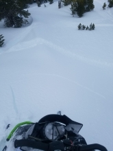
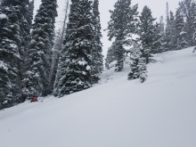
In the last 24 hours 8-10” of snow fell around Big Sky, 5” in Taylor Fork and near 10” around Lionhead. The Bridger Range, Hyalite and Cooke City received 2-4”. Under clearing skies temperatures are near 10F and winds are west at 15-20 mph, gusting to 40. Outside West Yellowstone and Cooke City winds are west at 10-20 mph. Today will be partly cloudy, temperatures will rise into the low 20s, and winds will be gusty out of the west. The southern ranges may get an inch of snow tonight.
The mountains do not have any new snow this morning, temperatures are single digits to teens F, and wind is southwest at 15-25 mph with gusts of 30-40 mph. Near Cooke City and West Yellowstone wind is 5-15 mph with gusts to 20 mph. Today, wind will be west-southwest at 20-30 mph with temperatures in the teens to low 20s F. Light snow is expected through today with 2-3” likely by morning.

The mountains did not get any snow since yesterday morning. Temperatures this morning are in the single digits to teens F. Wind overnight was north-northwest at 5-15 mph near Big Sky, Hyalite and Cooke City. In the Bridger Range and near West Yellowstone wind was 15-20 mph with gusts to 30 mph. Today will be partly cloudy with temperatures in the teens to low 20s F, and northerly wind at 10-20 mph will shift westerly this afternoon. Snow is expected early tomorrow with 3-5” possible by tomorrow evening.
Yesterday, the mountains near West Yellowstone and Cooke City picked over a foot of new snow. The mountains around Bozeman and Big Sky picked up 4-8”. This morning, snow has moved out of the region and skies are partly cloudy. Temps range from the single digits to low teens F and winds are blowing 10-20 mph out of the W-NW. Today, a weak ridge of high pressure builds over the area producing mostly clear and calm conditions. Temps will warm into the upper teens to mid-20s F and winds will remain light to moderate out of the W-NW. No snow is expected over the next 24 hours.

Since midnight, the mountains around Bozeman and Big Sky picked up 6-10” of new snow while the southern ranges picked up 4-6”. Snow will continue through the day with an additional 3-5” falling across the advisory area. At 5 a.m. temps range from the teens to mid-20’s F and winds are blowing 15-30 mph out of the west. Ridgetop gusts near West Yellowstone and Cooke City are pushing 40 mph. Temps will not warm much today as cooler air moves over the region. Winds will decrease through the day as the storm pushes to the east.


At 5 a.m. there’s no new snow to report and temperatures are in the upper 20’s to mid-30’s F under partly cloudy skies. Winds are blowing 20-30 mph out of the W-SW. Today, warm and windy conditions will continue as a storm approaches. Temps will warm into the 30’s to low 40’s and winds will remain moderate to strong out of the W-SW. Skies become increasingly cloudy throughout the day and the mountains will see light snow or rain showers by this afternoon. Precipitation increases this evening as the strongest part of the storm moves over the area. The mountains around West Yellowstone and Cooke City will see 3-5” by tomorrow morning while the mountains around Bozeman and Big Sky will see 2-4”. Light snow continues through the day tomorrow with an additional 1-3” possible in the north and 3-5” in the south.
Under clear skies mountain temperatures are near 20F with westerly winds averaging 10-15 mph and gusting to 25 mph. The Bridger ridge is windier, blowing west at 25-35 mph. Under sunny skies temperatures will rise to the low 30s before clouding up later this afternoon with increasing west winds. No snow is expected tonight and our next storm is Thursday evening

This morning has clear skies and temperatures in the teens to low 20s. Around Bozeman and Cooke City winds are westerly at 5-10 mph and 15-20 mph elsewhere. Today will be sunny, winds will remain light and mountain temperatures will reach the mid-30s in the northern ranges and high 20s in the south. The next snowfall is forecasted for Thursday night.