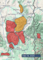
Advisory Archive

At 5 a.m. the mountains around Cooke City and West Yellowstone got 1” of new snow with 2” falling at Island Park. Wind is steady at 15-20 mph with gusts of 35 mph except in Island Park where 60 mph was recorded. Temperatures are in the high teens today and will rise into the upper 20s F under partly cloudy skies in the north and mostly cloudy in the south. A trace to 1” of snow will fall in the southern mountains today.


In the last 24 hours the mountains have gotten 1-2” of new snow with westerly wind at 10-15 mph and gusts to 30 mph. Temperatures are in the high teens under partly cloudy skies. Today will remain partly cloudy and the southern mountains could get a trace to 1” of snow. High pressure builds through the week with no major storms predicted.

There is no new snow. Temperatures range from single digits to high 20s F. Overnight wind was out of the southwest at 10-25 mph with gusts of 25-40 mph, and in Cooke City wind was 5-10 mph with gusts to 15 mph. Today, temperatures will reach 20s to low 30s F, and wind will continue from the southwest-west at 10-25 mph. Snow showers are expected, in the southern ranges this morning and northern ranges this evening, with 1-3” possible by tomorrow morning.


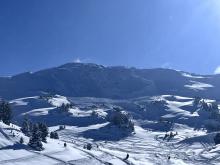
There is no new snow. Temperatures this morning range from the negative single digits to the low positive teens F. Winds are generally light and northerly, except for in the Bridger Range where westerly winds have picked up this morning and are now blowing 15-20 mph, both at the ridgeline and at mid-elevations. Winds will shift to the west and south as day progresses, generally remaining light (winds in the Bridgers will remain a bit stronger). Temperatures will rise into the 20s and low 30s F under sunny skies.
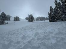
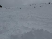
In the last 24 hours, 3-7” of new snow has fallen across most of the advisory area, with 2” in the Bridger Range. Temperatures this morning range from the single digits to teens F. Winds are 10-20 mph with 20-30 mph gusts out of the west to northwest, except in the Bridger Range which have also had some east winds. Winds tapered off a bit overnight and will be 5-15 mph and generally northerly today. Snowfall will finish up this morning with at most another inch or two accumulating. Skies will clear through the day with high temperatures reaching the teens and 20s F.


At 6 a.m. 2-4” of snow has fallen around Bozeman, 5” around Big Sky, and 5-8” in the south. Snowfall is predicted to continue in pulses today and tonight. Accompanying the snow is strong wind, mostly from the southwest, except the Bridger Range which is blowing east. Wind speed is averaging 15-20 mph with gusts of 35 mph, and West Yellowstone and Island Park measuring gusts up to 57 mph. Temperatures are currently in the high teens F. By tomorrow morning another 6-10” will fall in the south and 3-6” in the northern mountains.

Mountain temperatures are in the single digits to teens F this morning, with 5-15 mph winds from the northwest to southwest. The mountains received a trace to an inch of new snow as yesterday’s storm exited the area. Today, temperatures will be around 20 degrees F, with 5-15 mph winds from the west to southwest that increase toward the evening. Flurries will develop into accumulating snowfall overnight with 3-5” new around Cooke City, West Yellowstone, and Island Park, and 2-3” around Bozeman and Big Sky by tomorrow morning.


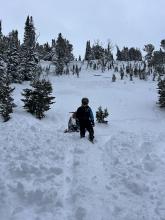
Mountain temperatures are in the single digits to teens F with 5-15 mph winds from the west to northwest. The Bridger Range and localized areas in the Northern Madison Range picked up 10” of snow in the last 24 hours, with 5-7” south of Bozeman and elsewhere around Big Sky and 2-4” near Cooke City, West Yellowstone and Island Park.
Today, temperatures will be in the 20s F with 5-15 mph winds from the west to southwest. Snowfall will taper off after an additional trace to 1” falls across the advisory area.


A snow shower last night dropped 1-2” near Big Sky, Bozeman, and West Yellowstone with none near Island Park and Cooke City. Wind has been west-northwest at 5-20 mph with gusts of 25-35 mph. Temperatures are teens to 20s F this morning. Today, temperatures will reach mid-20s F, and wind will be westerly at 10-20 mph. Snow showers through tomorrow morning will favor the mountains near Bozeman with 5-8”. Near Big Sky and Cooke City 3-5” are possible with 1-2” elsewhere.


Yesterday morning the Bridger Range got 4” of low density snow, 1” fell in Island Park, and none elsewhere. Last night wind increased out of the southwest and northwest at 10-30 mph with gusts of 25-45 mph. This morning temperatures are single digits to teens F. Today, temperatures will climb to the 20s F under partly sunny skies, and wind will be out of the west-northwest at 10-20 mph. Snow showers will return late tonight and tomorrow. Less than an inch will accumulate by tomorrow morning with more expected through tomorrow and during the week.