Advisory Archive
Under clear skies, last night’s low temperatures remained above freezing in the Bridger Range, upper elevations of Hyalite and Big Sky. Wind is W-SW at 10-20 mph with gusts of 43 mph in Island Park. Today will be breezy, sunny and temperatures reaching the mid-40s F in the north and high 30s F in the southern mountains.


Low temperatures for the night were above freezing across the advisory area other than Cooke City, where the Fisher Creek SNOTEL is at 23 degrees F. Winds are 5-15 mph from the west to the south. Today, temperatures will climb into the 40s F with 50 F in the Bridger Range and sunny skies.


Mountain temperatures are in the high 20s F this morning, except in the Bridger Range, where they are in the low to mid-30s F. Winds are 5-15 mph from the west to northwest, and the mountains around West Yellowstone and Island Park got one inch of snow mixed with a drizzle of rain. Today, temperatures will be in the mid to upper 30s F with mid-40s in the Bridger Range and 5-10 mph winds from the west to southwest. Skies will be mostly sunny around Bozeman and Big Sky and will clear through the day around West Yellowstone, Island Park, and Cooke City.


This morning there is no new snow. Temperatures are high 20s to low 30s F. Wind is westerly at 5-20 mph with gusts of 20-40 mph. Today will be mostly cloudy in the southern ranges to mostly sunny near Bozeman. Temperatures will reach mid-30s F most places and 40 F in the Bridger Range. Wind will be west-northwest at 15-30 mph. A few snowflakes could fall near West Yellowstone, Island Park and Cooke City, but no measurable accumulation is expected.


There is an inch of new snow near Island Park with none elsewhere. This morning, temperatures are teens to 20s F, and wind is out of the west-southwest at 10-20 mph with gusts of 20-40 mph. Today temperatures will reach high 20s to mid-30s F with west-southwest wind at 10-15 mph. Tonight through tomorrow there is a small chance for light snow showers at higher elevations south of Bozeman which could amount to 1-2” near Island Park and Cooke City.


This is a trace to an inch of new snow. Winds are generally light at 5-10 mph out of the west and north, except in the Bridgers where they are 15-20 mph and gusting to 35 mph. Temperatures this morning are in teens and low 20s F. Today will be mostly sunny, with high temperatures in the 20s and 30s F. Winds will remain light. Snow showers tonight won’t amount to significant accumulations.


In the last 24 hours 1-2” fell in Cooke City, West Yellowstone and Island Park. Southwest wind is blowing at 10 mph with gusts of 30 mph and mountain temperatures are 20 F. Today will become cloudy with wind blowing 10-20 mph out of the SW and switching NW tonight. By morning the southern mountains will have 1-2” of new snow and a trace to 1” south of Bozeman to Big Sky.

Yesterday 1-2” fell in Cooke City, West Yellowstone and Island Park. West wind is light with gusts to 25 mph and mountain temperatures in the low 20s F. Today will be partly cloudy in the north and mostly cloudy in the south. In the mountains, 1-2” is expected in the next 24 hours around Cooke City, West Yellowstone and Island Park.


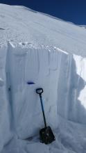
Mountain temperatures are in the 20s F this morning with 5-20 mph winds from the west to the south. The Centennial Mountains received 5” of heavy snow, with a trace to 1” in the mountains around West Yellowstone and Big Sky. Today, temperatures will be in the 20s to 30s F with 5-15 mph winds from the southwest. The mountains around Big Sky, West Yellowstone, and Island Park will get a trace to 1” of new snow by tomorrow morning.
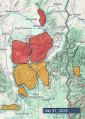
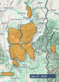
AVALANCHE WARNING
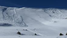
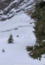
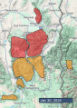
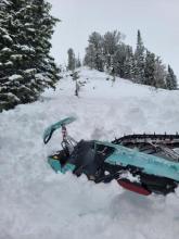
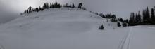
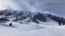
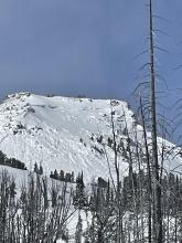
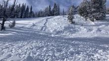
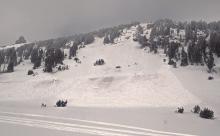
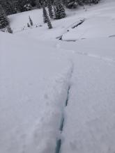
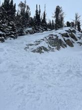
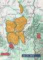
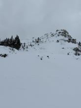
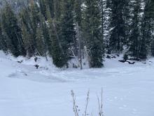
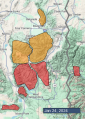
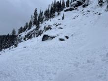
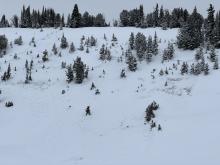
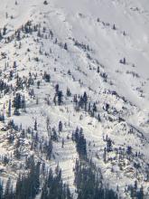
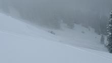
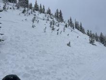
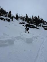
The Gallatin National Forest Avalanche Center is issuing a Backcountry Avalanche Warning for the Centennial Mountains in Island Park. New snow is overloading an exceptionally weak snowpack, creating very dangerous avalanche conditions. Human-triggered avalanches are very likely on all steep slopes. Avoid avalanche terrain and avalanche runout zones. The avalanche danger is rated HIGH on all slopes. Contact the Gallatin National Forest Avalanche Center for more detailed information.
This warning will expire or be updated by 6:00 a.m. on Wednesday, January 24th.


Mountain temperatures are in the teens to 20s F this morning, with west to south winds blowing 10-20 mph. There is 1-2” of new snow south of Big Sky through West Yellowstone and Cooke City, with 3” in Island Park. Today, temperatures will be in the upper 20s to 30s F with 10-20 mph winds from the southwest to the south. The mountains around West Yellowstone and Cooke City will get 1-2” of snow by tomorrow morning, with up to 4” in Island Park.

