Advisory Archive
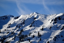
At 5 a.m. under clear skies, there’s no new snow, just wind (15-25 W) and temperatures of 10-15F. Winds in the Bridger Range have lessened from yesterday’s speeds of 35 mph that swirled from all directions. Today will be clear with temperatures reaching the mid-20s. High clouds will slide in from the NW tonight, and temperatures will drop into the teens. A high pressure ridge will dominate through the weekend and block any chance of snow.


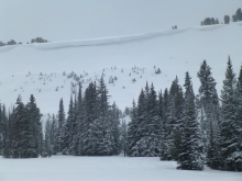
Snowfall continued in the northern mountains yesterday measuring 5” in the Bridger Range and 3” in Hyalite and around Big Sky. Westerly winds have increased and are blowing 40-50 mph in the Bridger Range and 15-30 mph everywhere else. At 5 a.m. mountain temperatures are in the low single digits (F) under mostly clear skies. High pressure builds today and skies will remain clear with temperatures reaching 20F and dropping into the single digits tonight. Wind speeds will lessen and remain light through the week.
Since yesterday morning new snow totals are 4-6” near West Yellowstone, 7” near Cooke City, 10” in the Bridger Range and Big Sky, and 12” in Hyalite. Temperatures this morning are single digits to teens F and will be low 20s F today. Wind is northwest-west at 10-15 mph with gusts of 25 mph. Near Cooke City wind is 30 mph with gusts of 50 mph. Today, northwest wind will continue at 10-20 mph with stronger speeds near Cooke. Lingering snow showers under mostly cloudy skies could bring another 1-2” of snow today.


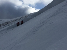
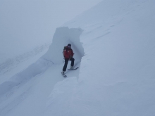
Since yesterday morning the mountains got 3” of new snow near Cooke City with 1-2” in the southern Madison and Lionhead Ranges. At 4 a.m. temperatures are low 30s F and wind is south to southwest at 10-20 mph with gusts to 45 mph. Temperatures will fall to low 20s and teens F today. Wind will be southwest at 15-30 mph this morning, then shift to the north-northwest at 5-15 mph this afternoon. Snow showers will begin this morning with periods of heavy snowfall expected today and through tonight. By morning the mountains will get 8-15” of snow near Big Sky, Hyalite, and West Yellowstone with 15-20” possible in the Bridger Range and near Cooke City.

Last night the mountains got 2” of new snow near Cooke City and no new snow elsewhere. This morning temperatures are teens to low 20s F and wind is southwest-west at 10-20 mph with gusts to 30 mph. Cloud cover will increase today with light snow showers, temperatures in the high 20s F, and wind at 15-25 mph out of the west-southwest. The mountains will get 2-4” of new snow by morning with more expected through tomorrow night.

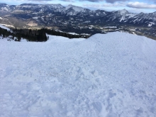
Overnight 1-2” of snow fell in the mountains around West Yellowstone and Cooke City. The mountains around Bozeman and Big Sky remained dry. This morning temps range from the upper teens to mid-20’s F under partly cloudy skies and winds are blowing 10-25 mph out of the west. Today, skies will gradually clear and temperatures will warm into the upper 20’s F. Winds will increase slightly as the progresses with ridgetop gusts reaching close to 30 mph by this afternoon. There is little chance for precipitation over the next 24 hours, but the mountains will see an increased chance of light snow showers tomorrow.
Yesterday morning a few inches of snow fell in the mountains around Bozeman and Big Sky. At 5 a.m. temps are in the teens under mostly clear skies and winds are blowing 10-20 mph out of the west. Today, skies will start out mostly clear, but will become increasingly cloudy as the day progresses. Winds will continue to blow 10-20 mph out of the west and temperatures will warm into the 20s F. There is a slight chance for snow showers in the southern mountains tonight, but only light accumulations are expected. Friday looks to be another nice, sunny day.
At 4:30 a.m. snow started falling in Bozeman. By 6 a.m. 4” fell at Bridger Bowl and 2” near Big Sky. This is a fast moving storm and in the next few hours snowfall will total 3-5” accompanied by strong winds and followed by clearing, sunny skies. Temperatures are currently in the mid-teens and winds are blowing steady from the west to south at 25-40 mph with gusts of 70 at Lulu Pass outside Cooke City and mid 50s everywhere else. Today will start snowy and end sunny with wind speeds decreasing after the storm passes.
At 6 a.m. SNOTEL is down, so snowfall totals outside ski areas are unknown.
Snowfall started at 4 a.m. yesterday morning and ended by noon, dropping 3” in the Bridger Range and 6-8” everywhere else. Westerly winds averaged 15-25 mph with gusts of 45 last night. Under clear skies temperatures fell to 10F in the mountains. Today will be sunny and temperatures will rise into the high 20s with W-SW winds averaging 15-25 mph. After midnight the mountains may get 1-2” of snow from a quick storm.

Snowfall started around 4 a.m. near West Yellowstone, Big Sky, and the Gallatin Range. Temperatures this morning are low 30s F and wind is southwest at 20-30 mph with gusts of 40-60 mph. A cold front passing this morning will bring temperatures in the 20s F today and low teens tonight. Wind will shift to the west-northwest at 15-20 mph, and snowfall this morning will total 3-6” with up to 8” possible near Big Sky, Hyalite, and Cooke City.
