Good Morning. This is Alex Marienthal with the Gallatin National Forest Avalanche Advisory issued on Monday, December 4th at 7:15 a.m. Today’s advisory is sponsored by Yellowstone Club Community Foundation and Beartooth Powder Guides. This advisory does not apply to operating ski areas.
NEW THIS SEASON: Regional Conditions Pages with region specific weather info, webcams, photos, videos, snowpits and more. Links at top of advisory and in the ‘advisory’ dropdown menu.
Since yesterday morning new snow totals are 4-6” near West Yellowstone, 7” near Cooke City, 10” in the Bridger Range and Big Sky, and 12” in Hyalite. Temperatures this morning are single digits to teens F and will be low 20s F today. Wind is northwest-west at 10-15 mph with gusts of 25 mph. Near Cooke City wind is 30 mph with gusts of 50 mph. Today, northwest wind will continue at 10-20 mph with stronger speeds near Cooke. Lingering snow showers under mostly cloudy skies could bring another 1-2” of snow today.

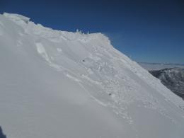
A foot of snow in Hyalite yesterday totaled 1.1” of snow water equivalent (SWE). In the Bridger Range and near Big Sky 10” of snow equaled .5” SWE, and near Cooke City snow since Friday totaled 1.2” SWE. Wind last night and today will drift new snow into 1-3 foot deep slabs that are easy to trigger. Near Cooke City, strong northwest wind formed slabs near ridgelines and along lower terrain like the edges of gullies and bases of cliffs. Yesterday, skiers near Cooke City backed off riding a steep couloir after they found a propagating wind slab in stability tests and heard a cornice break off a ridge nearby. Lower wind speeds near Bozeman and Big Sky will readily drift 10-12” of low density snow into slabs that are easy to trigger, located near ridgelines (video).
On non-wind loaded slopes, slabs of deep new snow are possible to trigger, and dry loose avalanches could run long distances on hard, supportable crusts underneath. Before travelling in steep terrain dig a couple feet to see how the new snow is bonding to the layers underneath, and watch for obvious signs of instability like cracking and collapsing and natural avalanches.
New snow and wind make avalanches easy to trigger today, and the avalanche danger is CONSIDERABLE. Avoid wind loaded slopes and carefully assess the snowpack before approaching steep terrain.
Aside from new snow and wind slabs the snowpack is generally stable and lacks widespread weak layers. A large avalanche triggered by Big Sky ski patrol on Thursday shows that isolated instabilities exist and large avalanches are not impossible (video, photo). On Saturday, skiers in Hyalite found old, weak snow near the ground breaking in stability tests and chose safer terrain for the day. It never hurts to do your homework before riding in steep terrain.

Near West Yellowstone and the southern Madison Range 4-6” of snow totaled .3-.5” SWE. Wind slabs will be possible to trigger near ridgelines, and could be 1-2 feet deep. On non-wind loaded slopes, the new snow is minimal weight on a generally stable snowpack and avalanches are not likely (video). Approach wind loaded slopes with caution. The avalanche danger today is MODERATE on wind loaded slopes and LOW on non-wind loaded slopes.
If you get out and have any avalanche or snowpack observations to share, drop a line via our website, email (mtavalanche@gmail.com), phone (406-587-6984), or Instagram (#gnfacobs).
Get Avalanche Smart Video Series
The Avalanche Center and Friends group work hand-in-hand to bring you daily avalanche information and education. This last video in series of 4 shows how we create a culture of being safe in the backcountry: Get Avalanche Smart – Episode 4: The GNFAC
Upcoming Avalanche Education and Events
BOZEMAN
Dec. 6, Avalanche Awareness, 6-7:30 p.m. at REI Bozeman
Dec. 7, Avalanche Awareness and Beacon Practice, 6-8 p.m. at Beall Park, Bozeman
Dec. 13, Avalanche Awareness, 6:30-8 p.m. at Gallatin Valley Snowmobile Association, 4-Corners
Jan. 12 and 13, Companion Rescue Clinic, Info and Register
Jan. 17, 18 and 20 or 21, Introduction to Avalanches w/ Field Day, Info and Register Here
Jan. 24, 25 and 27, Advanced Avalanche Workshop w. Field Day, Info and Register Here
Feb. 9 and 10, Companion Rescue Clinic, Info and Register
HELENA
7 December, Avalanche Awareness, 6-7:30 p.m. at Basecamp, Helena
WEST YELLOWSTONE
Dec. 14 and 15, Snowmobiler Introduction to Avalanches with Field Course, Info and Register Here
COOKE CITY
8 and 9 December, Current Conditions and Avalanche Rescue, 6:30-7:30 p.m. Friday @ the Super 8, and anytime between 10-2 on Saturday @ Lulu Pass road.
Bridger Bowl is closed and has a backcountry snowpack. This Friday (12/8) they open and uphill travel will be prohibited 24 hours/day. If you hike there this week, be aware that ski patrol is on the hill doing setup and avalanche control. Be aware of your surroundings above and below you.