Advisory Archive
Skies are partly cloudy, mountain temperatures are near 20F and west winds are averaging 15-25 mph with gusts of 40-45 mph in the Bridger Range and in Hyalite. Today will be partly sunny and west winds will decrease to 15-25 mph with daytime temperatures in the low 30s. Our next chance of snow is Sunday.


Under clear skies, mountain temperatures are in the mid-teens and winds are blowing west at 25 mph with gusts of 30-40 mph. Today will be mostly sunny and temperatures will rise into the low 30s. Winds will decrease from the west to 15-25 mph and tonight looks to be clear with another sunny day tomorrow.
This morning, temperatures are single digits F and winds are westerly at 5-15 mph. No snow has fallen in the last 24 hours. Today will be mostly sunny with temperatures rising into the low 20s F and winds out of the west-northwest at 10-20 mph. There may be some snow flurries tonight and tomorrow, but the next chance for significant snowfall is this weekend.
Last night a cold front entered the region with west-northwest wind at 20-35 mph and gusts of 50-70 mph. This morning, temperatures are single digits F and wind is northerly at 10-20 mph. Overnight the mountains got 2-3” of low density snow with 5-8” in Hyalite. Today will be mostly sunny with temperatures in the single digits to low teens F and wind out of the north-northwest at 10-20 mph. Late Wednesday is the next chance for light snow.

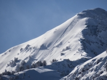
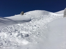
Yesterday the mountains got a trace to 1” of snow. Wind has been west to southwest at 15-25 mph with gusts of 35-45 mph. This morning, temperatures are teens F in the southern mountains and high 20s to low 30s F in the north. Today temperatures will be high 20s to low 30s F, then cool to the single digits F tonight. Wind will be west to northwest at 20-30 mph and stronger this evening. Expect snow late today and overnight. By morning, 4-6” is possible near Big Sky and Cooke City with 1-3” elsewhere.

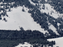
Since yesterday morning, the mountains near Bozeman and Big Sky picked up 5-7” of new snow while the southern ranges received 2-3”. At 5 a.m. temps range from the single digits near Cooke City to the low teens F elsewhere. North-northwest winds are blowing 30-50 mph in the northern ranges and 15-25 mph in the south. Today, an imbedded northwest flow will keep skies mostly cloudy and produce the occasional snow flurry in the mountains. By tomorrow morning, 1-2” of new snow is possible. Highs today warm into the upper teens to mid 20’s F and winds will remain moderate to strong out of the west-northwest.


Over the past 24 hours the mountains near Bozeman and Big Sky picked up 3-5” of new snow while the southern ranges including Cooke City received 1-2”. At 5 a.m. snow has tapered off and skies are partly to mostly cloudy. Temps range from the single digits to low teens F and winds are blowing 10-30 mph out of the west-northwest. Today, another storm arrives by mid-morning delivering moderate to heavy snowfall along with increasing winds. By tomorrow morning, the mountains near Bozeman and Big Sky will see 6-10” of new snow while the rest of the forecast area will see 4-6”. Temperatures today will remain in the teens and winds will blow 15-35 out of the west-northwest.
In the last 24 hours 8-10” fell in the northern mountains and 6-10” fell in the south. Temperatures are in the single digits to low teens with west to northwest winds averaging 10-15 mph with gusts of 30 mph. Today will be cloudy with scattered snow showers and similar wind. By tomorrow morning there will be 1-2” of new snow with a few more inches falling during the day.

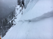
At 5 a.m. it is snowing and 5” have fallen in the Bridger Range and 3”-5” everywhere else. Snowfall will continue today with an additional 8-12” by morning, maybe more outside Cooke City. Winds are blowing west to south at 20-30 mph with gusts of 48 mph in the north and half that in the southern mountains. Today will remain windy with temperatures in the teens and snowfall will end this evening. If you are unable to call in sick this morning, (cough), you should probably do so tomorrow.
Since yesterday morning, 3-5” of new snow fell near Big Sky, with 1-3” in the rest of the advisory area. This morning, northwest winds are light and temperatures are in the single digits (F) to low teens (F). Winds will increase and shift to the southwest today. Snow will return tonight and continue through tomorrow. By tomorrow morning, expect 2-4” near West Yellowstone and Cooke City, with 3-6” near Bozeman and Big Sky.