Advisory Archive
At 6 a.m. the Bridger Range has 6” of new snow with 1-3” elsewhere. Temperatures range from -10F outside Cooke City to +4F in the Bridger Range. Winds are west to southwest (NW in Cooke) at 10-20 mph with gusts of 30 mph. Under mostly cloudy skies scattered snowfall will drop 2-4” in the Bridger Range and 1-2” elsewhere. Temperatures will rise into the teens and winds will shift northerly at 15-25 mph.


This morning there’s an inch of new snow near West Yellowstone and a dusting everywhere else. Mountain temperatures are -5F to -10F with west to southwest winds blowing lightly at 10-20 mph. Today will be cloudy and temperatures will rise into the high single digits before falling to zero tonight. South to southwest winds will pick up this afternoon to 15-25 mph and light snow showers will drop 1-2” overnight.


Yesterday light snow dropped 1” near West Yellowstone and almost a trace elsewhere. Wind has been easterly at 0-10 mph. This morning temperatures are single digits below and above zero F. Today temperatures will reach single digits and low teens F, and wind will be 5-10 mph and shift west-southwest this afternoon. There is a chance for scattered light snow showers to drop a trace to 2” by tomorrow.
This morning the mountains have a trace to 1” of new snow near Bozeman, Big Sky and West Yellowstone with 2-3” near Cooke City. Yesterday, wind was west-southwest at 15-20 mph with gusts near Bozeman and Big Sky to 40 mph. Today, wind is 0 to 10 mph and will shift east this afternoon. Temperatures are single digits F this morning, and today they will be single digits to low teens F. Light snow showers this afternoon and tonight will drop 1-2” by tomorrow morning.
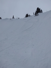
Overnight, 2-3” of new snow fell across the forecast area. At 5 a.m. temps range from the single digits to low teens F under partly cloudy skies. Winds are blowing 10-25 mph out of the west-northwest in the northern ranges and 15-25 out of west-southwest near West Yellowstone and Cooke City. Today, much colder air settles into the region with highs warming only into the teens F. Winds will remain light to moderate out of the west-northwest across the forecast area. Lingering snow showers could drop an inch or two by tomorrow morning.


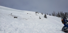
Over the past 24 hours the mountains around Cooke City, West Yellowstone and Big Sky picked up 6-7” of new snow while the mountains around Bozeman received 2-3”. At 5 a.m. light snow continues down south with dry conditions in the north. Temps are in the 20’s F under cloudy skies and winds are blowing 15-25 mph out of west-southwest. Light snow continues in the south with 2-3” possible by this afternoon, the northern mountains could see 1-2”. A heavier band of snow arrives this evening with an additional 3-5” likely across the forecast area.

The mountains around West Yellowstone received an estimated 16+” of snow and Cooke City received a foot. The mountains around Bozeman and Big Sky picked up 2-3”. Snowfall stopped at midnight and west to southwest winds subsided to 15 mph with gusts of 30-40 mph. Temperatures will remain in the teens today. Another snowstorm hits this afternoon and will drop 2-4” in the northern areas and close to 8” in the southern ranges by morning. Winds will continue to blow 15-30 mph out of the west to southwest.
At 5 a.m. there is 6” of new snow in Taylor Fork and 3-4” in Lionhead and Cooke City. Mountain temperatures are in the teens and winds are strong out of the west to southwest, averaging 20-30 mph with gusts exceeding 50 mph. Snowfall will blanket our area today and by morning I expect 6-8” in the mountains around Bozeman and Big Sky and a foot near West Yellowstone and Cooke City. Winds will remain strong and snow looks to continue into tomorrow.
Overnight 3-4” of dense snow fell in the Lionhead Range and near Cooke City, with no new snow elsewhere. Mountain temperatures are high single digits F to mid-teens. Winds are southwest to northwest at 15-30 mph with gusts into the 40s mph. Temperatures will rise into the teens and twenties with strong winds out of the south and southwest. Snow tonight will bring 3-5” around West Yellowstone and Cooke City, less near Bozeman and Big Sky.

This morning the mountains have 2-4” of new snow in Hyalite and near Big Sky and Cooke City, 3-6” in the Bridger Range, and 7-9” near West Yellowstone. Temperatures are around 0 F and winds are southwest at 15-25 mph with gusts into the 30s mph. Today, temperatures will rise into the teens with increasing southwest winds. Snow tonight will bring 2-3” near Bozeman, 4-7” near Big Sky, and 6-9” near West Yellowstone and Cooke City.