Advisory Archive
Montana is currently positioned on the leeward side of a ridge of high pressure sitting off the coast of California. This is generating a northwest flow over our area, producing mostly cloudy skies and cool temperatures. At 4 am this morning, mountain temperatures are ranging between 10 and 15⁰ F with Cooke City weather station being the coldest at 3⁰ F. Winds are averaging 10-20 mph out of the WNW with the exception of the Bridger Range where ridgetop winds are blowing 30-40 mph out of WNW. Today, temperatures will climb into the mid to high twenties under partly cloudy skies and winds will continue to blow 15-30 out of the WNW.


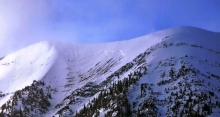
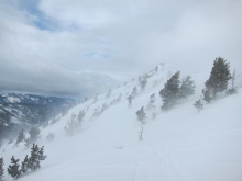
MOUNTAIN WEATHER
A dry cold front moving over southwest Montana is currently producing mountain temperatures in the low to mid teens. Winds are blowing out of the WNW at 10-15 mph. Very little moisture is associated with this front, but a trace to one inch of snow is possible in the mountains by early afternoon. This front will exit the area by mid day allowing temperatures to rise into the high teens to low 20’s under partly cloudy skies. Winds will remain out of the WNW at 10-15 mph.
AVALANCHE INCIDENTS
Final reports on last weekend’s avalanche accidents are available at: http://www.mtavalanche.com/accident

Temperatures dropped overnight and were in the mid teens F this morning. Winds were averaging 5-15 mph from the NW with gusts of 25-40 mph. No snow fell overnight and today will be mostly sunny. Winds will blow 10-20 mph from the W and NW, and temperatures will climb into the mid 20s F.
AVALANCHE INCIDENTS
Final reports on last weekend’s avalanche accidents are available at: http://www.mtavalanche.com/accident
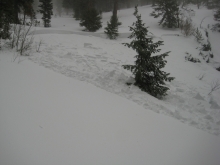
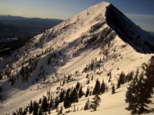
A resident of Cooke City hiked into Hayden Creek yesterday and confirmed that Ole the dog survived for 4 days buried 3ft deep. He likely heard Doug and Karl walking on the debris conducting the accident investigation while he was still buried. A video was posted documenting this tale of survival.


This morning temperatures were in the 30s F and winds were averaging 15-30 mph from the W and SW gusting 35-50 mph. This morning will remain warm and windy. Clouds will move over the area and by afternoon bring cooler air which will keep temperatures in the 30s F. Winds shouldn’t ease until this evening, and some areas could receive a dusting or even an inch of snow by tomorrow morning.
AVALANCHE INCIDENTS
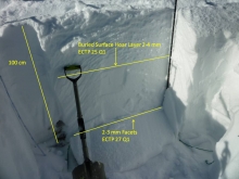
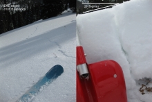
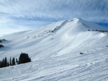
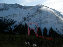
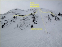
We have posted many photos and several videos from the two avalanche fatalities outside Cooke City. Full reports will be made public later this week.
Good news: In the avalanche in Hayden Creek south of Cooke City, a dog (a Corgi) was caught and presumed to be buried and dead. However, yesterday afternoon this dog appeared at the Antlers Lodge outside the hotel room where the victim and his wife were staying. Residents of Cooke City helped reunite this dog with its family.

Yesterday, under sunny skies, mountain temperatures hovered in the high 20s except in the Bridger Range where they hit the mid 30s. Winds are blowing west to southwest averaging 15-20 mph with gusts hitting 30 mph. Today will be sunny with wind speed and direction remaining the same. Temperatures, however, will approach their record highs and near 40F in the early afternoon.
AVALANCHE INCIDENTS
We have posted many photos on our website from the two avalanche fatalities outside Cooke City. We also have two video clips of our investigations posted:
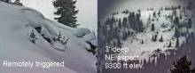
- Henderson Mountain avalanche involving a snowmobiler (video).
- Hayden Creek avalanche involving a skier (video).
- Remembering Dave Gaillard on Facebook.
Full reports will be made public later this week.


Yesterday was sunny and unseasonably warm with high temperatures in the Bridger Range reaching 45F. Other mountain areas had temperatures in the high 20s to low thirties. Winds blew hard out of the west to southwest with gusts hitting the 50s, but have lessened overnight and will die down even further this afternoon. Today will be more of the same: sunny and mild. This pattern of high pressure looks to stay with us through Thursday.


A building ridge of high pressure will bring sunny and unseasonably warm conditions to southwest Montana today. Currently mountain temperatures are in the mid twenties to low thirties with the exception of the mountains around West Yellowstone and Cooke City where temperatures are in the mid teens. Winds are blowing 10-20 mph out of the WSW and will gradually increase to 15-30 mph by this afternoon. Clear skies and warmer temperatures are expected through tomorrow.

Yesterday was a beautiful sunny day, and so will today. Without any new snowfall, mountain temperatures hovered in the single digits as winds blew out of the west to southwest at 20-30 mph with gusts of 40-60 mph seen early yesterday morning. Today, westerly winds at 15-20 mph will continue as temperatures climb into the low twenties. No new snow is expected for the next several days.
2011 goes out with a bang with snowfall measured in feet not inches. Since yesterday morning the mountains around Cooke City received 2 feet of snow. The mountains near West Yellowstone, the southern Madison Range, and the Bridger Range received 1 foot of new snow. Yes, that’s right the Bridgers got snow! The mountains near Big Sky and Hyalite Canyon received 6-9 inches of new snow. Strong winds continued as well and were blowing 20-40 mph this morning. They were blowing from the SW yesterday afternoon and shifted to the NW this morning. Temperatures were in the low teens F.
Snowfall ended this morning, and today skies will slowly clear allowing some sunshine. Winds will blow 15-20 mph from the WNW with gusts 30-35 mph. Temperatures may drop a bit more into the single digits F.