Advisory Archive
It snowed all day yesterday near Cooke City where an additional 12 inches of snow fell since yesterday morning. The Big Sky area and Hyalite Canyon received another 3-5 inches while further south near West Yellowstone and the Taylor Fork, the mountains received another 2-3 inches. The Bridger Range got a touch of rain yesterday and 1 inch of snow fell early this morning. Strong winds continued with gusts of 60-80 mph and steady 30-40 mph winds from the W and SW. This morning winds eased slightly and were blowing 25-40 mph from the SW. Temperatures were in the mid 20s F.
Snow was falling this morning at 4 a.m. and more will fall today and tonight. Guess which area will get the most snow? That’s right, the mountains near Cooke City will get another 16-20 inches. Mountains near West Yellowstone will get 10-12 inches, and mountains near Big Sky and south of Bozeman will get 6-8 inches. In the Bridger Range there will be a tug-of-war between snowfall and downslope winds which tend to limit snowfall. It’s hard to say who will win, but 2-4 inches should accumulate by tomorrow morning. Despite plentiful snow it may be hard to tell how much has fallen because winds will remain strong. Today they will blow steady at 15-20 mph gusting 40-60 mph from the SW. Temperatures will warm near 30 degrees F but a cold front moving over the area tonight will drop temperature into the single digits by tomorrow.
Since yesterday the mountains near Cooke City received 7-9 inches of snow and the mountains near Big Sky, the Taylor Fork and West Yellowstone received 4-5 inches. Near Bozeman, the northern Gallatin Range received 1 inch and the Bridger Range received none. All areas have temperatures near 30 degrees F and very strong winds blowing 15-30 mph from the W with gusts of 40-50 mph. Today temperatures should drop to near 20 degrees F by afternoon and strong winds will continue. A little more snow will fall this morning, then snow will return tonight and through Friday. By tomorrow morning most areas especially mountains from Big Sky south will receive 1-3 inches of snow.

This morning is warm and windy with fresh snowfall in the southern mountains. Four inches has fallen near Cooke City with 1-2 inches accumulating from the Yellowstone Club to West Yellowstone. Mountain temperatures are in the mid to high 20s as westerly winds average 30-40 mph with gusts hitting 50 mph. The jet stream will keep winds strong and create favorable dynamics for snowfall. By morning there could be 1-2 inches in the northern mountains and 6-8 inches in the southern ranges.
Currently, under cloudy skies, mountain temperatures are in the teens with westerly winds blowing 20-30 mph. A quick moving system will roll through this morning on a west to northwest flow. Winds will increase with gusts reaching the 40s and snow will fall, but it won’t amount to much—only 1-2 inches in the mountains. Another shortwave disturbance is lined up to hit us again tomorrow. Wow, two storms in one week. Could this be La Nina knocking at our door?
A dry-upper level weather disturbance is moving across southwest Montana producing strong gusty winds. This morning winds are blowing 20-40 mph out of the WNW with gusts reaching into the 50s. Mountain temperatures are in the mid teens to low twenties with Cooke City being the coldest at 9⁰ F. Today, temperatures will warm into the upper twenties and winds will stay elevated through the morning hours with gusts in the 50s possible. Winds will gradually decrease this afternoon. A cool and dry pattern will persist over southwest Montana through Tuesday.
Unseasonably warm and dry conditions will remain over southwest Montana through Christmas Day. Currently mountain temperatures are in the high teens to mid 20s and winds are blowing out of the west at 10-20 mph. Today temperatures will climb into the mid 30s under partly cloudy skies. Winds will gradually increase from the west blowing 20-30 mph by this evening. A weak cold front will arrive later tonight bringing cloudy and cooler conditions tomorrow. Unfortunately very little precipitation will be associated with this front.
A dry and mild weather pattern will persist over southwest Montana through the holiday weekend. Santa will likely have smooth sailing while making his rounds tonight into tomorrow. Currently – mountain temperatures are in the mid teens to low 20s and winds are blowing predominately out of the west at 15-30 mph. Today, temperatures will rise into the mid to high 20s under partly cloudy skies and winds continue to blow 15-30 mph out of the WNW.

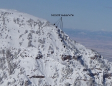
Yesterday was beautiful and clear but winds increased in the afternoon. This morning on ridgetops at Bridger Bowl and Hyalite Canyon winds were blowing 25-30 mph with gusts 40-50 mph from the W and NW. In other areas winds were blowing 15 mph gusting to 30 mph. Temperatures this morning were in the teens F and will climb into the 20s F today. Winds will remain strong generally blowing 15-30 from the NW; however, some downslope winds will occur today. It looks like the boys and girls of SW Montana have been bad this year and will not get any snow for Christmas. Instead of coal in our stockings, it looks like we’ll get a good dose of wind.
Since yesterday morning an additional 6-10 inches of snow fell in the Gallatin and Madison Ranges while the Bridger Range and Cooke City got an inch at most. Temperatures this morning were in single digits F and northerly winds calmed to 5-10 mph with some gusts of 15 mph. During the storm yesterday winds blew stronger at 15-30 mph sometimes from the E. Skies began clearing overnight and today will be mostly sunny with temperatures rising into the low teens F. Winds will remain northerly at 5-10 mph with some gust up to 20 mph.
It started snowing in the mountains around midnight which will continue today. At 6 a.m. the Gallatin and Madison Ranges (Bozeman to West Yellowstone) are showing 5-6 inches of light powder with Cooke City getting 2-3 inches and the Bridger Range 1-2 inches. Mountain temperatures are in the teens with northwest winds averaging 10-15 mph and gusts into the 20s. Snowfall will end later today with an additional six inches falling at the higher elevations.