Advisory Archive
Overnight 2-3 inches of snow fell throughout the advisory area. Winds decreased slightly from yesterday and this morning were blowing 10 mph with gusts of 25 mph from the W except in the Bridger Range where winds were blowing 20 and gusting to 30. Temperatures were in the low to mid teens F. Snow will continue this morning with an additional 2-3 inches falling. Some areas may see some sun this afternoon before another small dose of snow arrives Saturday. Temperatures will rise into the low 20s F, and winds will decrease a little by afternoon.
Clear skies overnight helped drop temperatures into the single digits to low teens F this morning. The recent period of abnormally calm winds may be ending. This morning westerly winds were averaging 10-15 mph with gusts in the 20s except in the Bridger Range and Hyalite Canyon where ridgetop winds were blowing 20-35 mph. Today, temperatures will warm into the high teens and low 20s F. Westerly winds will blow 10-15 mph with gusts of 20-30 mph. Tonight, moisture will descend from the northwest and produce an inch or two of new snow by tomorrow morning.


Before the storm ended yesterday morning an additional inch of snow fell in most locations. Winds blew westerly at 15-20 mph yesterday, but have calmed to 10 mph. Today skies will be mostly sunny, although the mountains around West Yellowstone and Cooke City will remain cloudy for most of the morning. No snow is in the immediate forecast. This morning mountain temperatures are in the single digits, but will warm to the upper teens as winds remain eerily calm.
This morning 3-4 inches fell in the northern mountains and 2-3 inches down south with light westerly winds averaging 10-15 mph. Temperatures are in the teens under cloudy skies. Scattered snow showers will drop another inch or two this morning. Under mostly cloudy skies mountain temperatures will rise into the 20s with winds remaining light out of the west.
During the past twenty four hours no new snow has fallen over our forecast area. This morning, mountain temperatures are in the teens under mostly cloudy skies and winds are blowing out of the WNW at 5-15 mph. Today, temperatures will warm into the mid twenties and winds will remain light out of the WNW at 5-15 mph. A weak weather disturbance will bring a chance of snow showers to the mountains through the day. A trace to one inch is possible by this afternoon. A better chance of snow will arrive later tomorrow.
Over the past 24 hours 1-2 inches of new snow has fallen in the mountains around Cooke City and West Yellowstone. The mountains around Bozeman and Big Sky have remained mostly dry. This morning, temperatures are in the low 20s under mostly cloudy skies and winds are blowing 5-10 mph out of the WNW. Today, temperatures will warm into the high 20s under mostly cloudy skies and winds will stay light out of the WNW. A weak weather disturbance will brush by our area producing a slight chance of mountain snow showers this afternoon.
Since yesterday most areas received 4-6 inches of snow. Winds have been incredibly calm but, yesterday evening they blew westerly 15-20 mph with 30-40 mph gusts. This morning winds were blowing 5-10 mph mostly from the west except in the Bridger Range where cold east winds dropped temperatures into the single digits to teens F. In all other places this morning, temperatures were in the low-mid 20s F. There may be some flurries today but no accumulation. Very calm winds will continue and mostly cloudy skies should keep temperatures from rising more than a few degrees.

Early yesterday most places received a dusting of snow. Near Cooke City 2-3 inches of snow fell with amounts up to 6 inches reported at higher elevations. Winds have been generally calm, blowing 10-15 mph this morning from the western half of the compass with some gusts in the 20’s. Temperatures were in the high teens F and should climb into the mid 20s F today. Winds shouldn’t change much and snowfall today will produce 2-4 inches by tomorrow morning. The weather pattern for the next few days looks promising with calm winds and light snowfall that could slowly improve skiing and riding conditions.


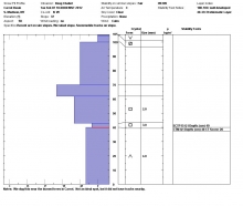
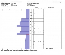
Winds this morning were blowing 20-30 mph from the W and NW with temperatures in the teens F. Today temperatures will warm into the mid 20s F and winds should calm a little blowing 10-20 mph from the W and NW. Skies will be a mix of sun and clouds and some snow should fall tonight. By tomorrow morning, 1-3 inches should fall mostly in the mountains near Bozeman. Since past weather is often a better predictor of future weather than long range models, check out a comparison of Bridger Range snowfall to other low snowfall years (graph).
Yesterday was a splitter day with lots of sun, temperatures in the teens and light winds. Ridgetop winds picked up slightly last night and are currently blowing 15-25 mph out of the west to southwest. Winds will continue today as temperatures rise into the mid 20s. Valley fog will give way to sunny skies this morning before more clouds roll in tonight and drop an angstrom or two of snow (one ten-millionth of a millimeter, aka flurries). By the way, has anyone seen La Nina? She’s missing and frankly I’m upset with her.