Good Morning. This is Alex Marienthal with the Gallatin National Forest Avalanche Forecast on Saturday, January 23rd at 7:00 a.m. Today’s forecast is sponsored by Mystery Ranch and Gallatin Valley Snowmobile Association. This forecast does not apply to operating ski areas.
Since yesterday morning the mountains received no new snow, except for a trace at Big Sky. This morning temperatures are single digits to teens F, and wind is out of the north and west at 5-15 mph. Today will have clearing skies with temperatures in the teens to low 20s F and northerly wind at 0-10 mph. The next chance for snow is Wednesday.

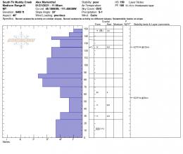
Buried persistent weak layers make human triggered avalanches possible today. A layer of weak, sugary snow near the ground is buried 2-3 feet deep on many slopes and has produced large avalanches this season. The most recent reported was triggered by a snowmobiler Tuesday in the southern Madison Range (photos and details). On Thursday Doug and I found this layer on Buck Ridge, in addition to a thin layer of surface hoar buried 8-10” deep (photo of layering). The sugary snow near the ground broke in our stability test which reminds us it remains unstable and is not going anywhere (video, snowpit profile). The surface hoar is not on all slopes, but the sugary depth hoar near the ground is on most.
Light wind with a couple inches of snow the last few days combined with continued calm, clear weather today gives weak layers a reprieve from additional load. Triggering an avalanche is becoming more difficult, but the possibility and consequences require careful terrain selection and diligent snowpack assessment. Be cautious of travel on and underneath slopes steeper than 30 degrees. Large avalanches are possible to trigger and the avalanche danger is rated MODERATE.
In the mountains near Cooke City a layer of surface hoar buried 12-18” deep produced avalanches, cracking and collapsing over the last week. On Tuesday, snowmobilers triggered an avalanche on this layer in Sheep Creek (details), and near Goose Lake skiers saw 2 human triggered slides that we suspect broke on this layer (details and photo). Additionally, a weak layer of sugary, faceted snow buried 2-3 feet deep exists on some slopes. Dave rode near Cooke City last Sunday and Monday and traveled as if these weak layers are on all slopes (video1, video2). Although these layers do not exist on all slopes, you can avoid avalanches by avoiding slopes steeper than 30 degrees. Otherwise, you have to diligently assess the snowpack which starts with a thorough review of recent avalanche activity (activity log) and media from the region (Cooke regional page), and should include digging to look for these layers before riding steep slopes. Today avalanches are possible and the avalanche danger is rated MODERATE.
If you get out, please send us your observations no matter how brief. You can submit them via our website, email (mtavalanche@gmail.com), phone (406-587-6984), or Instagram (#gnfacobs).
Upcoming Avalanche Education and Events
See our education calendar for an up-to-date list of all local classes. Here are a few select upcoming events and opportunities to check out:
Every Saturday in Cooke City, FREE snowpack update and rescue practice at the Round Lake Warming Hut between 10 a.m. and 3 p.m. Poster with More Info.
Thursday, January 26, 6-7 p.m. Free 1-hour Avalanche Awareness in partnership with Hi-Line Climbing Center and Stronghold Fabrication. Join on Zoom here.
SnowPilot has partnered with Community Snowobs to help understand snow depth in the alpine where measurements are difficult to make. http://communitysnowobs.org/snowpilot-easy-way-plot-share-snowpit-data/