Good Morning. This is Doug Chabot with the Gallatin National Forest Avalanche Forecast on Friday, January 22nd at 7:00 a.m. Today’s forecast is sponsored by Upper Yellowstone Snowmobile Club and Bridger Bowl. This forecast does not apply to operating ski areas.
At 5 a.m. the mountains have 1-2” of snow with Cooke City getting 3”. Winds are eerily light at 5-15 mph from the SW with mountain temperatures in the mid-teens F. Today will remain calm and skies will turn partly sunny as temperatures rise into the low 20s. A trace of snow may fall tonight, but no accumulation is expected until early next week.

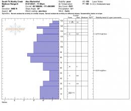
The snowpack from the Bridger Range to West Yellowstone is weak, not getting any stronger and gives me a headache. The problem is a thick layer of weak, sugary facets at the ground called depth hoar. This layer is 1-2 feet thick and is responsible for collapses, whumpfs and many avalanches (e.g. Tepee avalanche). A secondary problem is a thin layer of feathery surface hoar crystals about a foot down (photo of layering). While the depth hoar is on most slopes, the surface hoar is not. Yesterday, Alex and I rode around Buck Ridge, found it, and added it to our list of concerns. We also saw 7+ avalanches from 5-7 days ago (photo). In our stability test we were able to break the weak snow at the ground which caught our attention and should erase any fantasy thinking about this layer getting stronger (video, snowpit profile). A snowpack with depth hoar is not to be trusted.
Low snowfall and slopes stripped by wind has created a thin snowpack (photo). Thin and weak go hand-in-hand. Folks will continue to trigger an occasional avalanche if they get unlucky or careless. Continue to dig and look for surface hoar and test the weak snow at the ground, but no matter what I find I’m hesitant to get into avalanche terrain.
Given the poor snow structure, recent avalanche activity and two weak layers in the snowpack, the avalanche danger is rated MODERATE.
The mountains around Cooke City have 3” of new snow, enough to improve riding conditions without increasing avalanche danger. These mountains have two layers of concern: feathery surface hoar crystals buried 12-18” deep and a thin layer of weak grains 3 feet under the surface. These layers are not on every slope and there is no quick and easy way to find them without digging. On Tuesday, snowmobilers triggered this layer in Sheep Creek and luckily escaped getting caught, and near Goose Lake skiers saw 2 human triggered slides (details and photo). Dave and his partner were in these mountains Sunday and Monday and treated slopes as though these layers were on every one. His 2 videos explain what to look for (video1, video2). For today, the avalanche danger is rated MODERATE since a person could trigger a slide on one of these weak layers.
If you get out, please send us your observations no matter how brief. You can submit them via our website, email (mtavalanche@gmail.com), phone (406-587-6984), or Instagram (#gnfacobs).
Upcoming Avalanche Education and Events
See our education calendar for an up-to-date list of all local classes. Here are a few select upcoming events and opportunities to check out:
Every Saturday in Cooke City, FREE snowpack update and rescue practice at the Round Lake Warming Hut between 10 a.m. and 3 p.m. Poster with More Info.
Thursday, January 26, 6-7 p.m. Free 1-hour Avalanche Awareness in partnership with Hi-Line Climbing Center and Stronghold Fabrication. Join on Zoom here.
SnowPilot has partnered with Community Snowobs to help understand snow depth in the alpine where measurements are difficult to make. http://communitysnowobs.org/snowpilot-easy-way-plot-share-snowpit-data/