Good morning. This is Doug Chabot with the Gallatin National Forest Avalanche Forecast issued on Wednesday, January 2nd at 7:10 a.m. Today’s forecast is sponsored by Yellowstone Arctic Yamaha in partnership with the Friends of the Avalanche Center. This forecast does not apply to operating ski areas.
Under partly cloudy skies, mountain temperatures are near 10F. Strong west winds are blowing 20-30 mph and gusting to 45 mph in the northern ranges and 10-20 mph in the southern mountains. Skies will clear today and temperatures will rise into the upper 20s and drop into the teens tonight. Winds will be westerly and blow 20-30 mph in the north and 10-20 mph in the south. No new snow is expected through the week.

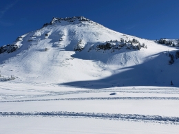
Yesterday, my partner and I took a tour into Lionhead to search for evidence of avalanche activity, and we found it (photo). The southern mountains have a very shallow and weak snowpack. The weekend’s storm dropped up to 18” of snow with strong wind that triggered many natural slides. We investigated one that broke 1-2 feet deep and 150 feet wide (video). It broke on a thick layer of sugary facets that is found on most slopes in the southern mountains (video). Winds were very strong on Monday and loaded many slopes that can be easily triggered. For today, the avalanche danger is rated CONSIDERABLE on wind-loaded slopes and MODERATE on all others.
In the northern mountains, winds drifted snow at the ridgetops and also at mid and lower elevations. These drifts will be easily triggered and could surprise us by pushing us into small terrain traps such as gullies or over cliffs. There was a lot of avalanche activity from the new snow (full list) on Sunday and Monday and signs of instability (cracking and collapsing) continued yesterday in areas with a shallow snowpack (less than 3 feet thick). Eric was on Mt. Ellis and wallowed in the sugary facets and got collapses, a sign of instability (video). Skiers in Dudley Creek and Beehive Basin also found an unstable snow structure on thinly covered slopes (details). The good news is that identifying areas of shallow, unsupportable facets is easy: you just sink in. Areas that are deeper will be stronger and more stable. For today, the avalanche danger is rated CONSIDERABLE on wind-loaded slopes and MODERATE on all others.

Around Cooke City, most of the weekend’s avalanche activity involved new or windblown snow. Yesterday, snowmobilers observed a number of small wind slab avalanches that occurred earlier in the week and highlight the continued possibility of triggering wind-loaded slopes (photo). A secondary, but not widespread problem involves facets 1.5-2 feet under the surface (video, photo), as well as shallow slopes consisting of unsupportable snow (video). In general, the mountains handled the storm snow well. Avalanches were small and most did not break into these deeper layers. The snowpack outside Cooke City is variable and trending toward stability. For today, be wary of wind-loaded terrain and do not get onto steep slopes if there is cracking and collapsing. The avalanche danger is rated MODERATE on all slopes.
Upcoming Avalanche Education and Events
Our education calendar is full of awareness lectures and field courses. Check it out: Events and Education Calendar.
BOZEMAN
TONIGHT, January 2, Avalanche Awareness, 6-7:30 p.m. at REI, Bozeman. Pre-register at https://www.rei.com/events.
January 8, Women’s Specific Avalanche Awareness, 6:30-8 p.m. Story Mill Park, Bozeman.
January 9, 1-hr Avalanche Awareness, 7-8 p.m. Spire Climbing Center, Bozeman.
January 16, 17 and 19 or 20, Intro to Avalanches w/ Field Day, Info and Register Here.
January 23, 24 and 26, Advanced Avalanche Workshop w/ Field Day, Info and Register Here.
February 2, King and Queen of the Ridge at Bridger Bowl (fundraiser). Info and registration is here, and then you can sign up to get pledges here.
WEST YELLOWSTONE
January 12 and 26, 1-hr Avalanche Awareness for Snowmobilers, 7-8 p.m. Holiday Inn West Yellowstone.
DILLON
January 22, 1-hr Avalanche Awareness, 6:30-7:30 p.m. U.M. Western Library.
BILLINGS
January 22, 1-hr Avalanche Awareness, 6-7 p.m. The Base Camp, Billings
COOKE CITY
Every Friday and Saturday, Rescue Training and Snowpack Update. Friday 6:30-7:30 p.m. at the Soda Butte Lodge. Saturday anytime between 10-2 @ Round Lake.
Read Doug’s recent article on Snowmobiler Education Efforts that will be published in the next issue of The Avalanche Review.