Good morning. This is Eric Knoff with the Gallatin National Forest Avalanche Forecast issued on Thursday, January 3rd at 7:10 a.m. Today’s forecast is sponsored by Yellowstone Ski Tours and Montana State Parks. This forecast does not apply to operating ski areas.
Since yesterday morning, most mountain locations picked up a trace to one inch of new snow. At 5 a.m. temperatures range from the single digits near West Yellowstone to the low 20’s F near Bozeman and Big Sky. Winds are blowing 15-35 mph out of the west-southwest. Today, temps warm into the mid to upper 20’s F under mostly clear skies. Winds remain moderate to strong out of the west-southwest. No new snow is expected over the next 24 hours.

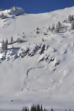
A well-developed layer of facets forms the foundation of the pack on most slopes in the southern Madison Range and mountains near West Yellowstone (video). This persistent weak layer was put under significant stress earlier in the week when it was loaded by 12-18” of new snow. On Tuesday, Doug rode in the Lionhead area and observed numerous natural avalanches that occurred during or immediately after the storm (video, photo). Since the storm ended on Monday, the snowpack has some time to adjust. Avalanches won’t be as easy to trigger today, but they still remain possible. All steep slopes should be considered suspect and approached with caution. It will be possible to remotely trigger slides from low angle or flat terrain. Keep in mind, if a slide does occur it will fail near the ground and likely be a large and dangerous.
Today, human triggered avalanches are possible and the avalanche danger is rated MODERATE.
There are two different scenarios going on in the mountains around Bozeman and Big Sky. In upper elevation terrain, the primary avalanche concern is wind loaded slopes. Areas loaded by west-northwest winds are the most likely to hold unstable conditions. Recently wind loaded slopes won’t be hair trigger, but still hold the potential to produce human triggered avalanches. Watch for rounded, firm pillows of wind drifted snow and approach these areas with caution. Fortunately, the snowpack lacks persistent weak layers at upper elevations, which will keep instabilities confined to new and wind-blown snow.
The second scenario is a shallow and weak snowpack on lower elevation slopes. Weak facets near the ground are now loaded by up to a foot of fresh snow. Widespread cracking and collapsing have been reported on Mt Ellis, Mt Wheeler, and lower terrain near Big Sky (video, photo). This is a clear indication unstable conditions exist where the snowpack is shallow and weak. Watch for signs of instability such as cracking/collapsing and avoid steep terrain where these signs are present.
Today, wind loading and weak layers make human triggered avalanches possible and the avalanche danger is rated MODERATE.
The storm over New Year’s did not produce much avalanche activity around Cooke City. A few small natural avalanches were observed on wind loaded slopes (photo), but in general the snowpack handled the load quite well. Although winds have been light the past few days, slopes loaded earlier in the week could still produce avalanches under the weight of a skier or rider. Watch for wind loaded slopes below ridgelines and cross loaded terrain features.
A secondary, but not widespread problem involves facets buried mid-pack and near the ground (video, photo, video). These layers have not been highly reactive, but are worth assessing before jumping into avalanche terrain.
The snowpack is trending towards stability, but avalanches remain possible on wind loaded slopes which have a MODERATE avalanche danger. Generally safe avalanche conditions exist on non-wind loaded slopes which have LOW avalanche danger.
If you get out and have any avalanche or snowpack observations to share, contact us via our website, email (mtavalanche@gmail.com), phone (406-587-6984), or Instagram (#gnfacobs).
Upcoming Avalanche Education and Events
Our education calendar is full of awareness lectures and field courses. Check it out: Events and Education Calendar.
BOZEMAN
January 8, Women’s Specific Avalanche Awareness, 6:30-8 p.m. Story Mill Park, Bozeman.
January 9, 1-hr Avalanche Awareness, 7-8 p.m. Spire Climbing Center, Bozeman.
January 16, 17 and 19 or 20, Intro to Avalanches w/ Field Day, Info and Register Here.
January 23, 24 and 26, Advanced Avalanche Workshop w/ Field Day, Info and Register Here.
February 2, King and Queen of the Ridge at Bridger Bowl (fundraiser). Info and registration is here, and then you can sign up to get pledges here.
WEST YELLOWSTONE
January 12 and 26, 1-hr Avalanche Awareness for Snowmobilers, 7-8 p.m. Holiday Inn West Yellowstone.
DILLON
January 22, 1-hr Avalanche Awareness, 6:30-7:30 p.m. U.M. Western Library.
BILLINGS
January 22, 1-hr Avalanche Awareness, 6-7 p.m. The Base Camp, Billings
COOKE CITY
Every Friday and Saturday, Rescue Training and Snowpack Update. Friday 6:30-7:30 p.m. at the Soda Butte Lodge. Saturday anytime between 10-2 @ Round Lake.
Read Doug’s recent article on Snowmobiler Education Efforts that will be published in the next issue of The Avalanche Review.