Advisory Archive

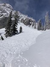
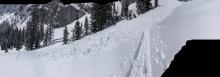
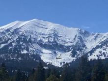
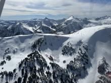
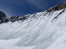
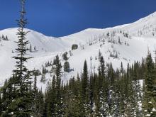
Since Tuesday evening the Bridger Range received 32-40” of snow, near Big Sky and Hyalite got 10-12”, and since Monday the mountains near West Yellowstone and Cooke City got 6-9”. Wind has been westerly at 5-20 mph with gusts of 15-30 mph. This morning temperatures are single digits to teens F. The next few days forecast is cold and generally snowy with temperatures reaching high 20s to low 30s F through Saturday, then mid-40s on Sunday. Wind will be 15-25 mph out of the west. The mountains near Bozeman and Big Sky are favored for snowfall with 3-5” possible today and 3-7” tomorrow through Saturday. Near Cooke City could receive 3-7” through Saturday and near West Yellowstone might see 2-4”.


This weekend, daytime temperatures climbed above freezing during the day with 5-20 mph winds from the southwest to the northwest. There was no new snow. Last night was the lightest freeze of the weekend, with temperatures in the upper 20s to low 30s F.
Monday will be the warmest day of the week, with temperatures in the 40s F under partly cloudy skies. Cloud cover will increase as the day progresses, and light snow begins Monday night. Snow and cooler temperatures will continue from Tuesday through Friday. The first pulse of snowfall will bring 5-6” to the Big Sky area, 4-5” to the mountains around Bozeman, and 2-4” near West Yellowstone and Cooke City by Wednesday morning.


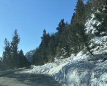
Yesterday snowfall dropped 13” in the Bridger Range, 10-12” in Cooke City and Hyalite, and 5-7” near Big Sky and West Yellowstone. This morning temperatures are single digits to teens F, and today temperatures will reach mid-20s to low 30s F. Yesterday wind was southwest at 15 mph with gusts of 25-45 mph, and this morning wind is northerly at 5-15 mph.
A couple inches of snow are possible today before skies clear for the weekend. Wind will remain calm to light out of the north through tomorrow, and on Sunday will shift westerly and increase to 15-25 mph. Temperatures will reach high 30s on Saturday and high 40s on Sunday. Overnight lows will be in the teens tonight and mid-20s to low 30s F the next couple nights.

This morning, temperatures are high 20s to mid-30s F, and wind is out of the southwest at 10-20 mph with gusts of 30-40 mph. Today will have increasing clouds and temperatures reaching low to mid-40s F. Wind will continue out of the southwest at 15-30 mph before colder air and snow arrive this evening. Tomorrow and Friday temperatures will be mid-20s to low 30s F, and tonight the mountains could get 1-3” of snow. Tomorrow heavy snow is expected to deliver 10-12” to most of the mountains in southwest Montana with more possible in the Bridger Range, Hyalite and Big Sky.


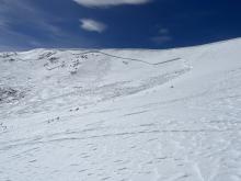
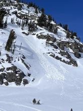
Mountain temperatures remained above freezing for the second night in a row, with lows in the 30s and 40s F. Winds ramped up to 10-30 mph from the south to the west and will increase through the day, averaging 20-45 mph. High temperatures will range from the upper 40s F to near 60 degrees F. Temperatures will likely drop below freezing tonight, and a potent spring snowstorm will move into the area Wednesday night.
Temperatures are generally in the mid-30s this morning, with only the highest elevations experiencing below-freezing temperatures last night. Winds are 10-15 mph from the west to southwest. Today, highs in the mountains will range from 50 to 60 degrees F with 10-20 mph winds from the south to the southwest.
This morning there is 1” of new snow near Cooke City and none elsewhere. Temperatures are mid-20s to low 30s F. Wind has been west-southwest at 15-20 mph with gusts of 30-40 mph. Today will be mostly sunny with temperatures reaching mid-40s F, and wind will be westerly at 10-20 mph. Very warm temperatures are expected the next couple days, then the next chance for snow is Tuesday night.


This morning, there is no new snow, temperatures are high teens to low 30s F, and wind is south-southwest at 15 mph with gusts of 30-55 mph. Today will be partly sunny with temperatures reaching mid-30s to low 40s F. Wind will be out of the west-southwest at 15-30 mph. No significant snow is expected for the next couple days.


There is no new snow. Winds are 10-15 mph out of the southwest and west with gusts of 25-30 mph. Temperatures are in the teens and low 20s F. Temperatures will rise into the 30s and 40s F this afternoon under mostly sunny skies. Moderate southwest winds will continue. Sunny skies and warm temperatures will continue through the weekend.
Last night 2” fell at Big Sky, and an inch in Taylor Fork and Cooke City. Wind is blowing west to southwest averaging 10-20 mph with gusts of 35 mph. Wind speed and direction will remain unchanged today. Under mostly clear skies mountain temperatures will rise from the single digits to the upper 20’s to mid 30’s F. No new snow is expected, but today is the first day of a potential 4 day solar storm of sunny skies, warm weather, and the emergence of alabaster white feet in flip-flops.