Advisory Archive
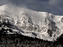
Early yesterday morning Cooke City squeezed out another three inches of snow while the Red Lodge Ski Area got hammered with over 20”! Currently mountain temperatures are in the high teens to low twenties under partly cloudy skies. Winds are west to southwest averaging 30 mph with gusts of 50 mph around Bozeman, and averaging 15-20 mph everywhere else. High pressure is moving in and forecasted to stay through the weekend. Today will be partly cloudy with temperatures reaching the low thirties and wind speeds decreasing.
In the last 24 hours the mountains have picked up an inch of new snow, except Cooke City which received another five inches. At 5 a.m. temperatures are in the high teens with ridgetop winds blowing from the west at 30-35 mph and gusting to 50-70 mph. Today is a day of transition as high pressure moves into Montana. Winds will decrease to 20-30 mph, temperatures will rise into the low thirties and skies will become partly sunny. The rest of the week’s weather looks to be sunny, stable and quiet.

Over the past 24 hours the mountains around Cooke City received 6 inches of new snow while the mountains around Big Sky picked up 4-5 inches. The Bridger Range and Mountains around West Yellowstone picked up 2-3 inches of new snow. At 4 a.m. temperatures are in the mid-teens to low twenties F and westerly winds are cranking 25-35 mph with stronger gusts reaching over 40 mph. Today, snow will taper off and temperatures will warm into the upper twenties to low thirties F. Strong winds will impact the area throughout the day blowing 25-35 mph out of west-northwest with stronger gusts reaching upwards of 50 mph. A ridge of high pressure will begin to build this evening producing calmer and drier conditions tomorrow.
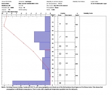
What a storm! Over the past 24 hours the mountains around Cooke City have received well over a foot of snow totaling 1.5 inches SWE (snow water equivalent). The mountains around West Yellowstone including the southern Madison Range received close to a foot of snow totaling 1 inch of SWE while the mountains around Bozeman and Big Ski picked up around three inches of snow totaling .3 inches of SWE.
The one element that has not been spared is WIND! Consistent winds of 20-30 mph out of the west-southwest have been blowing all night with gusts close to 50 mph being recorded in most locations. Today, winds will decrease slightly, but will pick back up this afternoon.
This morning temperatures are in the mid-teens to low twenties F under partly to mostly cloudy skies. Precipitation has shut off, but there is an increasing chance of mountain snow showers later in the day. Highs will warm into the upper twenties F and winds will continue to blow 20-40 out of the west-southwest. 1-2 inches of snow is possible in the northern mountains and 3-5 inches in the southern mountains by tomorrow morning.
Yesterday, the mountains around Cooke City picked up 6-8 inches of new snow. Most other areas picked up 1-3 inches with the exception of the Bridger Range which remained dry. This morning, temperatures are in the upper teens to mid-twenties F and winds are blowing 15-30 mph out of the WSW with localized gusts reaching into the 40s. Today, winds will increase out of the west as the next storm system approaches. Sustained wind speeds of 25-35 mph can be expected with gusts reaching into the 50s at higher elevations. Today will be the warmest day of the week with highs reaching into the mid to upper 30s F under mostly cloudy skies. Valley rain and mountain snow should start to impact southwest Montana by this afternoon. The southern mountains will receive the heaviest snowfall with 4-6 inches likely by tomorrow morning. The northern mountains should pick up 2-4 inches.

More snow is falling this morning. From yesterday at 6 a.m. to this morning at 6 a.m. 7 inches of snow fell in the Bridger Range, 10 inches near Big Sky and West Yellowstone, and closer to 12 inches near Cooke City. Temperatures were in the teens F and winds had increased some since yesterday blowing 10-20 mph gusting to 40 mph from the SW. Winds should shift to the W today and increase especially near Bozeman and Big Sky. High temperatures will be near 20 degrees F. This morning an additional 3-5 inches of snow should accumulate and snowfall should end early this afternoon. More snow should come early Saturday with even stronger winds.
Snow has been slowly trickling into the area and more should come over the next few days. It’s currently snowing. As of 6 a.m. the mountains near Bozeman have received 1-3 inches of snow while the rest of the area has received about 6 inches of new snow. This morning temperatures were hovering near 20 degrees F. Winds increased and were blowing 10-20 mph gusting to 30 mph from the SSW. Today temperatures should slowly drop into the teens F. Winds should continue blowing 10-30 mph but shift to the W. An additional 3-5 inches should come today and snowfall should end early this evening.

Yesterdays scattered snowfall dropped 2-3 inches in the northern areas and an inch in the south. Winds have calmed substantially and are blowing 15-20 mph out of the west to southwest at the ridgetops. Temperatures are in the high teens up north and near 10F in the south. Today will become mostly cloudy and by tomorrow morning I expect another 1-3 inches of snow with light winds and temperatures reaching into the mid-20s.
Yesterday was sunny and windy with speeds measuring 30-50 mph out of the west. They are much calmer this morning with ridgetop breezes at 10-25 mph out of the southwest. Temperatures are in the low 20s in the northern half of the advisory areas and near 10F around Cooke City and West Yellowstone. Today will be mostly cloudy and scattered showers will drop 1-2 inches of new snow overnight.
Since yesterday morning the mountains around Bozeman and Big Sky picked up a trace to one inch of new snow. The southern mountains remained dry. Currently, temperatures are below zero around Cooke City, but 5-10 degrees above zero elsewhere. Winds are a bit blustery blowing 15-25 mph out the west-northwest with stronger gusts being recorded in the mountains around Bozeman and Big Sky. Today will feel balmy compared to yesterday with highs climbing into the upper teens to mid-twenties F under mostly clear skies. There will be a wind chill as west-northwest winds continue to blow 15-25 mph. The ridge of high pressure that is currently parked over southwest Montana will remain in place for the next 24 hours, but will begin to break down tomorrow as another weak storm system approaches from the west.