Advisory Archive
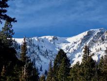
Yesterday, the groundhog saw his shadow, which means six more weeks of winter. Hopefully an active and snowy weather pattern continues during this time. Over the past 24 hours, the mountains around Cooke City picked up 3-5” of low density snow while the mountains around Big Sky and West Yellowstone picked up 1-2”. This morning, mountain temps are in the single digits to low teens F under partly to mostly cloudy skies. Winds are blowing 15-25 mph out of the W-SW with ridgetop gusts in Hyalite and Big Sky hitting close to 40 mph. Today, temps will warm into the teens to low 20s and winds will steadily increase out of the W-SW. A storm system will move into the area this evening producing light to moderate snowfall in the southern mountains. Cooke City, West Yellowstone and Big Sky will see 4-6” by tomorrow morning while the mountains around Bozeman will see 1-3”.


Over the past 24 hours no new snow has fallen. At 5 a.m. temperatures are in the single digits above or below zero F under mostly cloudy skies. Winds are blowing 5-15 mph out of the E-SE. Today, temps will warm into the single digits to low teens F and winds will shift to a more westerly direction. A quick moving storm enters the advisory area later this morning and the mountains should see 1-3” of snow by this afternoon. Conditions dry out tonight, but another round of snow is expected Friday night into Saturday.

Storm totals from 4 a.m. yesterday are 12” in the Bridger and northern Gallatin Ranges, 10” in the Big Sky area, 7” in Taylor Fork, 3-4” around West Yellowstone and 14-16” outside Cooke City. Winds have been blowing 10-20 mph out of the W-SW, except in the Bridger Range where they are east. Temperatures are in the single digits under partly cloudy skies with lingering snow showers this morning. Winds will remain light and temperatures will warm into the teens. A smaller storm approaches pre-dawn tomorrow that will bring 3-6” throughout the day.
It’s snowing! The mountains are showing 2-4” at 6 a.m. with Cooke City grabbing 7”. Winds are blowing W-SW (NW in Cooke) at 20 mph with gusts of 30-50 mph. Mountain temperatures are in the high teens. Today’s weather is simple: snow will fall, winds will blow and temperatures will drop. By tomorrow morning, storm totals in the mountains will measure 12-16” outside Cooke City and 8-12” everywhere else. Winds will be gusty from the W-SW and temperatures will drop into the single digits tonight. More snow is predicted for Thursday so start coughing, develop the sniffles and lay the groundwork for calling in sick.
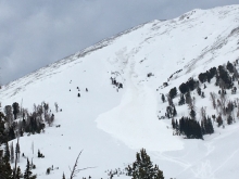
The mountains have not had any new snow for the last four days. Temperatures yesterday reached the low 30s F in most locations, and low 40s F at lower elevations in the northern ranges. Temperatures this morning are teens to mid-20s F and wind is out of the west to southwest at 15-30 mph with gusts of 40-60 mph near Bozeman and Big Sky. Today will be partly sunny with temperatures in the high 20s F to low 30s F and wind will be out of the west at 15-25 mph. Tomorrow, early morning snow will deliver a couple inches before sunrise with another 4-7” through the day. Snow totals of 1-2 feet are expected through Wednesday, and snow in the mountains is likely to continue through next weekend.


Temperatures this morning are 20s to low 30s F and wind overnight was out of the west to northwest at 20-30 mph with gusts in the 40s. The mountains have not had any new snow over the last three days. Today will be clear with high clouds and temperatures in the high 20s to 30s F. Wind will be out of the west to northwest at 15-25 mph today, and will increase tonight to 30-40 mph prior to unsettled weather and a chance for snow Monday night.
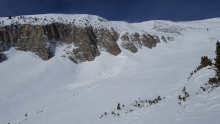
The mountains have not received any new snow since Wednesday night. Temperatures this morning are teens to low 20s F, and in the single digits near West Yellowstone. Wind has been out of the west to northwest at 25-40 mph with gusts of 40-50 mph. Strong wind will continue through Sunday, and remain out of the west today at 25-35 mph with gusts to 40 mph. Temperatures today will be 20s to low 30s F. The next chance for new snow is Monday night with more through the week.
No new snow has fallen over the past 24 hours. At 5 a.m. temperatures range from the single digits to low teens F under mostly clear skies. Winds out of the W-NW are blowing 5-15 mph in the southern ranges and 15-30 mph in the north. At 4 a.m. Big Sky reported a gust of 51 mph. Today, gusty winds will continue in the northern ranges but remain light to moderate in the south. Temps will warm into the upper teens to low 20s F and skies will remain mostly clear. No new snow is expected over the next 24 hours.
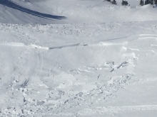
Overnight a sneaky snowstorm entered the Bridgers and dropped 6-8” of low density snow. This puts the 24 hour total at Bridger Bowl close to a foot. The rest of the advisory area picked a trace to 1”. At 5 a.m. it’s still snowing at Bridger Bowl and skies are partly to mostly cloudy elsewhere. Temperatures are in single digits above zero F with the exception of Cooke City where temps are a few degrees below zero F. Winds are blowing 5-15 mph out of the W-NW. Snow showers will linger in the northern mountains this morning, but the storm pushes out by this afternoon and skies will become partly to mostly cloudy. A ridge of high pressure builds over the area tonight and tomorrow producing clear and calm conditions.
There’s no new snow to report, just cold temperatures. At 5 a.m. temperatures are in the low single digits under partly cloudy skies. Winds are light out of the N-NW at 5-10 mph. Today, temperatures will reach the upper teens with ridgetop winds blowing lightly from the north. Clouds will increase later this afternoon and an inch of snow may fall tonight. Tomorrow we get fed another serving of high pressure bringing sunny skies and dry weather through the weekend.