Good morning. This is Dave Zinn with the Gallatin National Forest Avalanche Forecast on Tuesday, April 4th at 7:00 a.m. This information is sponsored by Gallatin County Sheriff Search and Rescue and Grizzly Outfitters. This forecast does not apply to operating ski areas.
This morning, temperatures are in the single digits to teens F with 5-15 mph wind from the northeast to northwest. Winds are blowing 30-40 mph from the east to the north in the Bridger Range. The mountains received a trace to 1” of snow overnight. Today, temperatures will be in the teens to 20s F with 10-20 mph winds from the north. A trace to 2” of snow will fall by tomorrow morning.

Strong winds gusting to 75 mph from the east to the north are blowing in the Bridger Range, drifting snow into unstable slabs where triggering an avalanche is likely. Winds are scouring slopes that are commonly wind-loaded and depositing the snow in unusual patterns. Watch for mounds of drifted snow, a stiffening of the snow surface or shooting cracks to help identify areas of concern. Recent natural avalanches breaking 1-3’ deep on wind-loaded slopes in the Bridger Range are good examples of the problem (Battle Ridge, Naya Nuki).
Avalanches breaking on weak layers deep in the snowpack are less likely, but a natural avalanche above Ainger Lake that broke 3-4 feet deep and 500 feet wide this weekend is a clear indicator that they remain possible (details and photos).
Take a step back and seek out more conservative terrain that is sheltered from the wind. The avalanche danger is CONSIDERABLE on wind-loaded slopes and MODERATE on all others.

Human-triggered avalanches breaking 1-2’ deep are possible within slabs of recently wind-drifted snow and 4-6’ deep where persistent weak layers are buried in the snowpack. The more likely of the two problems is triggering an avalanche within the wind-drifted snow, and the more dangerous is a deep slab avalanche that could propagate long distances across slopes.
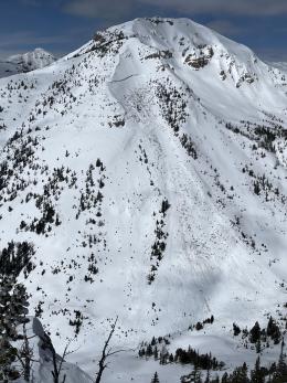
Concern about deep slab avalanches should drive decision-making. Reckon with the consequence of getting caught if you choose steep terrain, especially in higher elevation wind-loaded terrain. Riding in the Lionhead area yesterday, we saw evidence of a natural avalanche cycle that occurred Saturday night through Sunday and included a slide that broke 4-6’ deep and ran to the creek below (observations, video, photos). Similar deep slab avalanches near Cooke City and in the Southern Madison Range broke over 1000’ wide during this weekend’s storm (Woody Ridge avalanche, Hilgard avalanche + video). The best mitigation strategy is patience and conservative terrain selection. Choose lower-angle slopes sheltered from the wind and with fewer terrain features to exacerbate the consequences of getting caught.
Wind-slab avalanches breaking within recently drifted snow are more likely. Recent examples include a natural avalanche on Woody Ridge (photos and details), a skier triggered a slide on Mineral Mountain (photo and details), six natural avalanches above Beaver Creek (video), and several slides below the cornice on Lionhead Ridge (video). Avoid recently and commonly wind-loaded slopes, dig down three feet to test the upper snowpack and watch for signs of instability, such as shooting cracks or stiffening of the snow surface, that indicate problem areas.
The danger is MODERATE.
Please share avalanche, snowpack or weather observations via our website, email (mtavalanche@gmail.com), phone (406-587-6984), or Instagram (#gnfacobs).

Human-triggered avalanches breaking 1-2’ deep are possible within slabs of recently wind-drifted snow and 4-6’ deep where persistent weak layers are buried in the snowpack. The more likely of the two problems is triggering an avalanche within the wind-drifted snow, and the more dangerous is a deep slab avalanche. Choose lower-angle slopes sheltered from the wind and with fewer terrain features that would exacerbate the consequences of getting caught. Dig down three feet to test the snowpack and watch for signs that indicate problem areas, such as shooting cracks or stiffening of the snow surface.
Skiers in the Hellroaring Creek drainage reported a widespread avalanche cycle around Nemesis Mountain during this weekend’s storm. The larger avalanches leveled many trees (observation and photos).
Upcoming Avalanche Education and Events
Hyalite Canyon road is closed for motorized use until May 16.