Good morning. This is Ian Hoyer with the Gallatin National Forest Avalanche Forecast on Friday, March 25th at 7:00 a.m. This information is sponsored by Yellowstone Club Community Foundation and Uphill Pursuits. This forecast does not apply to operating ski areas.
Mountain temperatures dropped below freezing overnight and are in the 20s F early this morning. There is no new snow. Winds are 5-10 mph out of the west to northwest with gusts to 20 mph. Skies are partly cloudy this morning. There will be a mix of sun and clouds today. Westerly winds will be 5-15 mph with gusts to 30 mph. Temperatures will rise into the 40s F this afternoon and maybe even reach the 50s F at lower elevations. Temperatures this weekend are forecast to be even higher.

All Regions
With high temperatures forecasted to be 5 F warmer than yesterday, wet snow avalanches are the primary concern today. Sunny skies and warm temperatures don’t feel as ominous as a big storm, but they can create avalanche conditions that are just as dangerous.
A decent refreeze overnight has formed a stout crust on most slopes. Conditions will become more dangerous as the crust breaks down. The faster temperatures climb, the less windy it is and the less cloud cover there is - the more quickly dangerous conditions will develop. Wet loose avalanches are the most likely problem you’ll encounter today, but big, deadly, wet slabs are also possible. If you’re sinking more than ankle deep into wet snow it’s time to get off steep, sunny slopes (video). Plan to be off steep slopes early and keep steep low elevation slopes you’ll need to cross to get home at the end of the day in mind as you’re route planning. Cornices have also been breaking off with these warm temperatures, so think twice before spending much time beneath them.
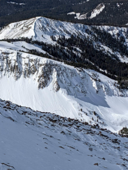
Yesterday, skiers triggered an avalanche that broke 3 ft deep and 300 ft wide in Republic Creek, south of Cooke City (details, photo). It broke across three adjacent gullies and caught three skiers, burying one with only an arm sticking out of the snow. Two of the skiers were injured but thanks to prompt rescue efforts by their partners, the outcome was not worse. Natural slab avalanches were also seen on Sawtooth Mountain near Cooke City (photo) and in the Lone Lake Cirque (in the backcountry outside Big Sky Ski Resort, photo). Any slope with wet snow at the surface should be suspect, but cold, dry, shady slopes aren’t a get out of jail free card - you could still trigger a dry slab avalanche there on the weak layers buried 1-3 ft deep.
Wet snow avalanches are particularly hard to predict. Give yourself big safety margins and don’t try to outsmart the snowpack as it goes through a rapid change.
Both wet and dry avalanches are possible today and the avalanche danger is rated MODERATE.
If you get out, please send us your observations no matter how brief. You can submit them via our website, email (mtavalanche@gmail.com), phone (406-587-6984), or Instagram (#gnfacobs).
This article in the Billings Gazette highlighting Dave’s January accident, shoulder injury and rescue is worth your time. Plan ahead and prepare for dealing with an injury in the backcountry and think about how you’d call for outside help.