Good Morning. This is Doug Chabot with the Gallatin National Forest Avalanche Forecast on Wednesday, December 15th at 7:00 a.m. This information is sponsored by Beartooth Powder Guides, Advanced Innovation and Werner Wealth Management (Advisors with DA Davidson). This forecast does not apply to operating ski areas.
In case you haven’t noticed, it snowed. In the last 24 hours the Lionhead area, Southern Madison Range and Southern Gallatin Range got 12” of snow, Bozeman and Big Sky area have 6-8” and Cooke City got 2”. West to northwest wind is averaging 10-20 mph with gusts of 35 mph. Mountain temperatures are in the low teens. Today will become sunny and temperatures will rise into the 20s with wind speeds remaining westerly and moderate. A couple more inches may fall in the southern mountains tonight, but overall the storm is over.
Avalanche Warning
Over 3 feet of snow fell outside Island Park, Idaho since Sunday and we are continuing the AVALANCHE WARNING for this area since very dangerous avalanche conditions exist. The avalanche danger is rated HIGH on all slopes. Avalanches can be triggered from low on the slope and from adjacent slopes far away. Do not get on or underneath steep slopes.

In the last 24-hours a foot of snow amounting to 1” of snow water equivalent (SWE) fell in the mountains south of Big Sky to West Yellowstone. Since Saturday this amounts to over 30” of snow. Yesterday, Ian and his partner rode into Taylor Fork and saw wind drifts shoot deep cracks far ahead on the trail. Dave was in Lionhead on Monday and triggered a “whumph” on his skis (video). These two obvious signs of instability will continue today. They are warnings to not get into avalanche terrain. A few natural avalanches will be seen in the backcountry which is a red flag to stay off slopes since triggering avalanches is likely, no matter if you are on skis or a snowmobile. The snowpack depth doubled in some spots and even deeper wind-drifts are on many aspects and elevations.
Today is a day to be careful around avalanche terrain. The fresh snow is inviting, but it needs time to stabilize and strengthen. For today the avalanche danger is rated CONSIDERABLE on all slopes.
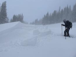
This morning folks around Bozeman and Big Sky are scrambling to find their snow shovels. It snowed as much in town as it did in the mountains, about 8” (.5-.7 SWE). West to northwest wind is gusty and blowing snow. The snowpack is 2-3 feet deep and weak layers of sugary, faceted snow are found in most of our snowpits (photo of weak snow in Hyalite, Bridgers video). With last night’s snow and wind-loading these layers could be triggered. Wind drifts at the ridgelines and in gullies should be avoided today. Wind drifts will crack and avalanche from human triggers so keep your powder stoke in check. As evidence, yesterday a skier triggered a shallow and small wind slab north of Bridger Bowl on the Ramp. For today the avalanche danger is rated CONSIDERABLE on all wind-loaded terrain since triggering wind-drifts will be easy. Slopes without a wind-load have a MODERATE danger.

The mountains around Cooke City got 2” since yesterday morning bringing their storm total since Saturday to 17-20” (1.7” SWE). Wind was blowing most of that time loading and drifting slopes. There is a weak layer buried in the snowpack that Ian and Alex found last week (Cooke City video 1, Cooke City video 2). It was windy the last 4 days (Lulu Pass Weather Station) and on slopes with wind-drifts this layer is our primary concern. It’s always a good practice to avoid wind-loaded slopes. Dig and assess the snowpack before committing to avalanche terrain and don’t let your guard down. For today the avalanche danger is rated MODERATE on wind-loaded slopes and LOW on all others.
If you get out, please send us your observations no matter how brief. You can submit them via our website, email (mtavalanche@gmail.com), phone (406-587-6984), or Instagram (#gnfacobs).
Upcoming Education Opportunities:
Get your avalanche brain ready for the season at one of the many classes listed on our education calendar, and list of upcoming events below. Don’t delay preparing and inspecting your avalanche gear. Get some tips from Dave Zinn in this Pre-Season gear check video.
Wednesday, December 15, 6-7 p.m. FREE Sidecountry Avalanche Awareness for Families (and Friends). In partnership with Bozeman Parks and Recreation at Beall Park. A 1-hr avalanche awareness talk with an emphasis on “Sidecountry Terrain and Snowpack.”
Every Saturday near Cooke City, 10a.m.-3p.m. FREE snowpack update and transceiver/rescue training. Stop by for 20 minutes or more. At the Round Lake Warming Hut.
Friends of GNFAC Powder Blast Fundraiser
The Friends of the Avalanche Center are hosting the Virtual Powder Blast fundraiser. With only $2,000 left to go, help us reach the $65,000 goal. Your donations support free and low-cost avalanche education, beacon checkers at trailheads, beacon parks, weather stations, and GNFAC programs!
Sadly, on Saturday a group of skiers was caught in an avalanche in the backcountry near Crystal Mtn., Washington and one person was killed. Link to Article. Our deepest condolences go out to those affected by this tragic event.