Good Morning. This is Doug Chabot with the Gallatin National Forest Avalanche Forecast on Friday, January 15th at 7:30 a.m. This forecast is sponsored by Highline Partners and Spark R&D. This forecast does not apply to operating ski areas.
At 5 a.m. under clear skies there is no new snow. Mountain temperatures are in the high teens F and wind is west to northwest at 20-25 mph with gusts of 50 mph in the Bridger Range. Clouds will increase and temperatures will reach the upper 20s F as winds shift NW at 20-30 mph. Snowfall tonight will drop 2-3” in the mountains with another storm predicted Sunday night and Monday.

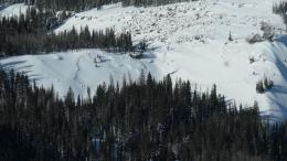
On Wednesday the mountains got blasted by strong wind and snowfall which resulted in many natural avalanches throughout southwest Montana (8 entries in our Avalanche Activity Log). No mountain range escaped the wind: stripping the snow to dirt on some slopes (photo) and making dense wind drifts on others. Surprisingly these drifts have bonded well and are not cracking or sliding. Dave was in Taylor Fork yesterday and documented 10 avalanches, most small-sized and breaking under the new snow (video, details and photos).
On Tuesday, a layer of feathery surface hoar crystals got buried and preserved. It might have been the weak layer under the new snow in the Taylor Fork avalanches. Regardless, we know it is in all ranges but not on all slopes. It is shallowly buried and easy to look for.
Other avalanches involve depth hoar, the large, weak, sugary grains at the ground (photo of crystals). We have recorded these in almost all of our snowpits and videos. I investigated slides on this layer in Lionhead (video), while others saw cracking, collapsing and/or avalanche activity in the S. Gallatin, Madison and Bridger Ranges on it. Dave and his partner backed off skiing avalanche terrain in Bacon Rind on Tuesday (video) after finding this persistent weak layer.
There are now 2 layers in the snowpack to investigate: surface hoar near the top and depth hoar at the bottom. Follow our advice and dig, test and be conservative like Dave was in Bacon Rind. There have been many recent avalanches and triggering more is very possible. For today the avalanche danger is rated MODERATE on all slopes.
On Wednesday, the mountains outside Cooke City got blustery wind, snowfall, and avalanche activity up Hayden Creek (photo) and off the highway (photos). Wind drifted snow was not reactive yesterday, which is good news. However, the snowfall buried a new weak layer of feathery surface hoar (photo) that has our full attention because it may avalanche with the next few snowstorms. Yesterday, skiers got it to break clean in their stability test. Additionally, sprinkled throughout Cooke City is a layer of weak snow buried 2-3 feet deep that is responsible for recent avalanches. We are not done looking for this layer or trusting it. Two weak layers sporadically distributed makes stability assessment complicated. Digging and searching for these weak layers is the most prudent thing to do. Skipping this step leaves you with only one viable option: avoiding avalanche terrain. For today, triggering avalanches is possible on one of these layers which points to a MODERATE avalanche danger.
If you get out, please send us your observations no matter how brief. You can submit them via our website, email (mtavalanche@gmail.com), phone (406-587-6984), or Instagram (#gnfacobs).
Upcoming Avalanche Education and Events
See our education calendar for an up-to-date list of all local classes. Here are a few select upcoming events and opportunities to check out:
Every Saturday in Cooke City, FREE snowpack update and rescue practice at the Round Lake Warming Hut between 10 a.m. and 3 p.m. Poster with More Info.
TONIGHT, January 15 and 16, Companion Rescue Clinic, 6-8 p.m. Friday Zoom online, Saturday field session 10am - 2pm. Register HERE.
Tuesday, January 19, 6-7 p.m. The Friends of the Avalanche Center will offer a FREE 1-hr Avalanche Awareness Talk in partnership with the University of Montana Western School of Outreach. The talk will be a live, ONLINE event. Join us HERE.
January 20 & 21 (plus field sessions the following weekends), Avalanche Fundamentals with Field Course. There are separate field sessions tailored for both skiers and splitboarders (Bridger Bowl) and snowmobilers (Buck Ridge). Register here.
Ski-Doo is offering free avalanche education classes online that you can take here: https://www.ski-doo.com/avalanche.html