Good morning. This is Eric Knoff with the Gallatin National Forest Avalanche Forecast issued on Saturday, March 30th at 6:30 a.m. Today's forecast is sponsored by Knoff Group Real Estate and Werner Wealth Management. This forecast does not apply to operating ski areas.
Since yesterday morning a trace to one inch of snow fell across the forecast area. At 5 a.m. temps range from the single digits to low teens F under clear skies. Winds are blowing 5-10 mph out of the east-northeast. Today, a ridge of high pressure will produce sunny skies and temps in the 30’s F. Winds will remain light out of the east-northeast. No snow is expected over the next 24 hours.

All Regions
Bridger Range Madison Range Gallatin Range Lionhead Area near West Yellowstone Mountains near Cooke City
The avalanche equation is pretty simple. Stability will start off good this morning but decrease during the day due to rising temperatures and direct sun. The northern mountains have an increased chance of wet loose avalanche activity since they received 4-6” of new snow over the past few days, but the southern mountains will also experience heat/sun induced hazard (video).
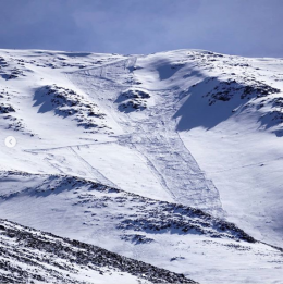
Obvious signs of instability will be easy to recognize. Pin wheels and small point releases are bull’s eye data that instability is on the rise. Wet loose avalanches will start on south and east aspects and progress onto to west facing slopes as the sun climbs higher in the sky (video). Slides will likely stay confined to new snow and not step down or gouge into deeper layers (photo). Loose snow slides won’t be exceptionally powerful, but they could push a skier or rider into hazardous terrain such as rocks, trees, or gullies.
A good way to manage wet snow avalanche problems is by starting backcountry travel early in the morning and finishing before surface snow becomes unstable or move to shadier slopes when signs of instability are present.
A secondary avalanche concern is wind slabs that have formed beneath upper elevation ridgelines (photo). This problem isn’t widespread, but something to keep an eye out for when exploring high alpine objectives, specifically those facing north through east.
Today, the avalanche danger will start out LOW but rise to MODERATE by this afternoon.
If you get out and have any avalanche or snowpack observations to share, contact us via our website, email (mtavalanche@gmail.com), phone (406-587-6984), or Instagram (#gnfacobs).
Spring is here and wet snow avalanches are becoming a daily concern. Anticipate decreasing stability while forming a travel plan. This article from Backcountry Magazine highlights some things look for that indicate when it is time to turn around.